TopoQuest Logo
Do you find TopoQuest useful?
Help keep TopoQuest running and adding new maps/features by donating!
Bitcoin:  19c7KJd3qBynnjoSw5npx9KScwjBe4ifkT
Litecoin:  LXs6TkuXGGXo1vDsWCkWVdjQX94eUKd6ui
Home View Maps Find Maps Find Places Resources & Links


Lagonda, Missouri Topographic Map

USGS Map Title: Lagonda, MO
USGS Map MRC: 39092F6
DRG (GeoTIFF) Download: o39092f6.tif


Neighboring USGS Topographic Map Quads:


  New Cambria West, MO  
39092G7
 

  New Cambria East, MO  
39092G6
 

  Bevier North, MO  
39092G5
 

  Wien, MO  
39092F7
 

  Lagonda, MO  
39092F6
 

  Bevier South, MO  
39092F5
 

  Bynumville, MO  
39092E7
 

  Prairie Hill, MO  
39092E6
 

  College Mound, MO  
39092E5


Map MRC Location:

N40°
W93°
N40°
W92°
H8 H7 H6 H5 H4 H3 H2 H1
G8 G7 G6 G5 G4 G3 G2 G1
F8 F7 F6 F5 F4 F3 F2 F1
E8 E7 E6 E5 E4 E3 E2 E1
D8 D7 D6 D5 D4 D3 D2 D1
C8 C7 C6 C5 C4 C3 C2 C1
B8 B7 B6 B5 B4 B3 B2 B1
A8 A7 A6 A5 A4 A3 A2 A1
N39°
W93°
N39°
W92°

Lagonda, MO USGS 1:24K Topographic Map Preview:
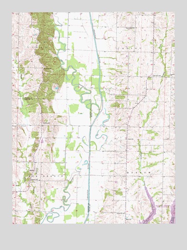
Lagonda, MO USGS Topographic Map
Click on map above to begin viewing in our Map Viewer.

This topographic map contains these locations and features:
Feature Name Type Latitude Longitude GNIS ID View Map
BarryvillePopulated PlaceN39.6678°W92.6621°733723View Map
Concord CemeteryCemeteryN39.7116°W92.6271°2702431View Map
Concord ChurchChurchN39.7117°W92.6282°716178View Map
Davis SchoolSchoolN39.6750°W92.6610°716738View Map
Dodson CemeteryCemeteryN39.7364°W92.7296°716943View Map
HammackPopulated PlaceN39.7173°W92.7255°759900View Map
Hammock SchoolSchoolN39.7167°W92.7260°719048View Map
Johnson CemeteryCemeteryN39.6500°W92.7371°720362View Map
Johnson SchoolSchoolN39.6514°W92.7357°720383View Map
Kaseyville SchoolSchoolN39.6320°W92.6641°720480View Map
LagondaPopulated PlaceN39.6570°W92.7330°720738View Map
Marshall School (historical)SchoolN39.6317°W92.6357°733724View Map
Minefree SchoolSchoolN39.6848°W92.7266°722420View Map
Morrow School (historical)SchoolN39.6714°W92.6327°733722View Map
Mulnix LakeReservoirN39.6739°W92.7270°762218View Map
Mulnix Lake DamDamN39.6734°W92.7285°762217View Map
Number 21 LakeReservoirN39.7052°W92.7158°760712View Map
Oak Grove SchoolSchoolN39.7123°W92.6427°723604View Map
Rice CemeteryCemeteryN39.6653°W92.7344°725247View Map
Rose Hill School (historical)SchoolN39.7445°W92.7452°733721View Map
Sleepy HollowValleyN39.6303°W92.7263°726543View Map
Swan LakeLakeN39.7384°W92.6564°733725View Map
Swan Lake SchoolSchoolN39.7406°W92.6557°727360View Map
Temple Stephens Company DamDamN39.7050°W92.7152°760711View Map
Tenant BranchStreamN39.6828°W92.7382°727529View Map
Township of CallaoCivilN39.7410°W92.6599°766959View Map
Township of MorrowCivilN39.6535°W92.6534°766973View Map

Note: Coordinates in the location and feature list above are referenced to NAD83 datum.


Copyright (C) 2008-2024 Ryan Niemi / Sunset Dynamics ... All Rights Reserved