TopoQuest Logo
Do you find TopoQuest useful?
Help keep TopoQuest running and adding new maps/features by donating!
Bitcoin:  19c7KJd3qBynnjoSw5npx9KScwjBe4ifkT
Litecoin:  LXs6TkuXGGXo1vDsWCkWVdjQX94eUKd6ui
Home View Maps Find Maps Find Places Resources & Links


Bynumville, Missouri Topographic Map

USGS Map Title: Bynumville, MO
USGS Map MRC: 39092E7
DRG (GeoTIFF) Download: o39092e7.tif


Neighboring USGS Topographic Map Quads:


  Marceline, MO  
39092F8
 

  Wien, MO  
39092F7
 

  Lagonda, MO  
39092F6
 

  Mike, MO  
39092E8
 

  Bynumville, MO  
39092E7
 

  Prairie Hill, MO  
39092E6
 

  Keytesville, MO  
39092D8
 

  Salisbury, MO  
39092D7
 

  Clifton Hill, MO  
39092D6


Map MRC Location:

N40°
W93°
N40°
W92°
H8 H7 H6 H5 H4 H3 H2 H1
G8 G7 G6 G5 G4 G3 G2 G1
F8 F7 F6 F5 F4 F3 F2 F1
E8 E7 E6 E5 E4 E3 E2 E1
D8 D7 D6 D5 D4 D3 D2 D1
C8 C7 C6 C5 C4 C3 C2 C1
B8 B7 B6 B5 B4 B3 B2 B1
A8 A7 A6 A5 A4 A3 A2 A1
N39°
W93°
N39°
W92°

Bynumville, MO USGS 1:24K Topographic Map Preview:
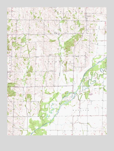
Bynumville, MO USGS Topographic Map
Click on map above to begin viewing in our Map Viewer.

This topographic map contains these locations and features:
Feature Name Type Latitude Longitude GNIS ID View Map
Bee BranchStreamN39.5092°W92.8310°713853View Map
Beulah ChurchChurchN39.5475°W92.8660°714119View Map
Brewer School (historical)SchoolN39.5928°W92.8477°734055View Map
BynumvillePopulated PlaceN39.6167°W92.7760°715162View Map
Bynumville Fire Department Station 1BuildingN39.6126°W92.7751°2620766View Map
Cooper School (historical)SchoolN39.5622°W92.8582°734057View Map
East Bee BranchStreamN39.5847°W92.8066°717252View Map
EchoPopulated PlaceN39.5981°W92.8485°740603View Map
Elm BranchStreamN39.5667°W92.7681°717503View Map
Fairview CemeteryCemeteryN39.5631°W92.8213°717767View Map
Fitzgerald CemeteryCemeteryN39.5995°W92.8030°717967View Map
Grove BranchStreamN39.5442°W92.7810°718898View Map
HamdenPopulated PlaceN39.5772°W92.8232°740900View Map
Kelly ChurchChurchN39.5764°W92.8388°720514View Map
McCurry School (historical)SchoolN39.5631°W92.8235°734056View Map
Mount Zion ChurchChurchN39.5995°W92.8138°722961View Map
Musselfork CemeteryCemeteryN39.5592°W92.8744°724178View Map
Parks CemeteryCemeteryN39.5328°W92.8460°724042View Map
Parks School (historical)SchoolN39.5339°W92.8416°734058View Map
Pee Dee SchoolSchoolN39.5620°W92.8746°724179View Map
Pleyer SchoolSchoolN39.5770°W92.7894°724657View Map
Slaughter AirportAirportN39.6146°W92.8632°2679358View Map
Township of CockrellCivilN39.5744°W92.8081°766461View Map
Township of WaylandCivilN39.5228°W92.7573°766470View Map
Walker School (historical)SchoolN39.5047°W92.8674°734059View Map
West Bee BranchStreamN39.5847°W92.8069°728528View Map

Note: Coordinates in the location and feature list above are referenced to NAD83 datum.


Copyright (C) 2008-2024 Ryan Niemi / Sunset Dynamics ... All Rights Reserved