TopoQuest Logo
Do you find TopoQuest useful?
Help keep TopoQuest running and adding new maps/features by donating!
Bitcoin:  19c7KJd3qBynnjoSw5npx9KScwjBe4ifkT
Litecoin:  LXs6TkuXGGXo1vDsWCkWVdjQX94eUKd6ui
Home View Maps Find Maps Find Places Resources & Links


Lampasas, Texas Topographic Map

USGS Map Title: Lampasas, TX
USGS Map MRC: 31098A2
DRG (GeoTIFF) Download: o31098a2.tif


Neighboring USGS Topographic Map Quads:


  Ogles, TX  
31098B3
 

  Flat Top Peak, TX  
31098B2
 

  Rumley, TX  
31098B1
 

  Nix, TX  
31098A3
 

  Lampasas, TX  
31098A2
 

  Kempner, TX  
31098A1
 

  Naruna, TX  
30098H3
 

  Lake Victor, TX  
30098H2
 

  Bachelor Peak, TX  
30098H1


Map MRC Location:

N32°
W99°
N32°
W98°
H8 H7 H6 H5 H4 H3 H2 H1
G8 G7 G6 G5 G4 G3 G2 G1
F8 F7 F6 F5 F4 F3 F2 F1
E8 E7 E6 E5 E4 E3 E2 E1
D8 D7 D6 D5 D4 D3 D2 D1
C8 C7 C6 C5 C4 C3 C2 C1
B8 B7 B6 B5 B4 B3 B2 B1
A8 A7 A6 A5 A4 A3 A2 A1
N31°
W99°
N31°
W98°

Lampasas, TX USGS 1:24K Topographic Map Preview:
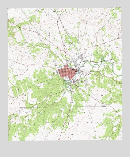
Lampasas, TX USGS Topographic Map
Click on map above to begin viewing in our Map Viewer.

This topographic map contains these locations and features:
Feature Name Type Latitude Longitude GNIS ID View Map
Bailey CemeteryCemeteryN31.0095°W98.1315°1351408View Map
Bean CreekStreamN31.0343°W98.2206°1350781View Map
Brooks ParkParkN31.0552°W98.1811°2028736View Map
Burleson CreekStreamN31.0696°W98.1700°1353330View Map
Capital AmbulanceBuildingN31.0640°W98.1802°2656134View Map
Cemetery CreekStreamN31.0691°W98.1728°1354183View Map
Challenger High SchoolSchoolN31.0655°W98.1806°2007955View Map
Church of ChristChurchN31.0705°W98.1870°2022621View Map
City of LampasasCivilN31.0652°W98.1833°2411619View Map
Community ChurchChurchN31.0657°W98.1792°2022623View Map
Cook CemeteryCemeteryN31.0568°W98.1742°1354898View Map
East Fork Sulphur CreekStreamN31.0343°W98.2200°1356638View Map
Espy BranchStreamN31.0430°W98.2381°1357073View Map
First Presbyterian ChurchChurchN31.0649°W98.1811°2022622View Map
Gibson BranchStreamN31.0713°W98.1670°1357996View Map
Gold SpringSpringN31.0471°W98.1814°1358118View Map
Gooch BranchStreamN31.0707°W98.1570°1358143View Map
Gooch SpringSpringN31.0693°W98.1571°1358144View Map
Gunderland ParkParkN31.0721°W98.1448°1358522View Map
Hancock ParkParkN31.0535°W98.1842°1358719View Map
Hancock SpringsSpringN31.0552°W98.1831°1998515View Map
Hanna Springs Intermediate SchoolSchoolN31.0738°W98.1817°2007956View Map
Indian BluffCliffN31.0432°W98.2325°1359916View Map
Jones LakeReservoirN31.0932°W98.1998°1864977View Map
Jones Lake DamDamN31.0918°W98.2003°1864976View Map
KCYL-AM (Lampasas)TowerN31.0755°W98.1842°1387858View Map
Keystone Square MuseumBuildingN31.0660°W98.1792°2014551View Map
LampasasPopulated PlaceN31.0638°W98.1817°1360911View Map
Lampasas AirportAirportN31.1034°W98.1941°1387046View Map
Lampasas Baptist ChurchChurchN31.0652°W98.1839°2022619View Map
Lampasas City HallBuildingN31.0652°W98.1795°2753274View Map
Lampasas County Constable's OfficeBuildingN31.0646°W98.1781°2750616View Map
Lampasas County Sheriff's OfficeBuildingN31.0645°W98.1782°2750322View Map
Lampasas DivisionCivilN31.0990°W98.1671°1938907View Map
Lampasas Fire DepartmentBuildingN31.0646°W98.1805°2551995View Map
Lampasas High SchoolSchoolN31.0599°W98.1828°2007957View Map
Lampasas Middle SchoolSchoolN31.0688°W98.1831°2007958View Map
Lampasas Police DepartmentBuildingN31.0647°W98.1799°2750455View Map
Lampasas Post OfficePost OfficeN31.0640°W98.1634°2732167View Map
McNett CreekStreamN31.0355°W98.2131°1362535View Map
Oak Hill CemeteryCemeteryN31.0718°W98.1975°1364285View Map
Pecan BranchStreamN31.0724°W98.1353°1364953View Map
Phillips and Trosper BuildingsBuildingN31.0657°W98.1786°2031740View Map
Pillar BluffCliffN31.0246°W98.2453°1365235View Map
Pillar Bluff CreekStreamN31.0293°W98.2245°1365236View Map
Radio JunctionPopulated PlaceN31.0768°W98.1686°1365946View Map
RevisionLocaleN31.1213°W98.1964°1366389View Map
Rollins Brook Community HospitalHospitalN31.0723°W98.1861°2718212View Map
Scott HollowValleyN31.0034°W98.1391°1367885View Map
Second Baptist ChurchChurchN31.0793°W98.1689°2022620View Map
Soil Conservation Service Site 3 ReservoirReservoirN31.0419°W98.2494°1856173View Map
Soil Conservation Service Site 4 DamDamN31.0252°W98.2453°1856196View Map
Soil Conservation Service Site 4 ReservoirReservoirN31.0240°W98.2451°1856197View Map
Soil Conservation Service Site 5 DamDamN31.0902°W98.2186°1856164View Map
Soil Conservation Service Site 5 ReservoirReservoirN31.0893°W98.2171°1856165View Map
Soil Conservation Service Site 6 DamDamN31.0352°W98.2286°1856170View Map
Soil Conservation Service Site 6 ReservoirReservoirN31.0352°W98.2286°1856171View Map
Soil Conservation Service Site 7 DamDamN31.0518°W98.1920°1856168View Map
Soil Conservation Service Site 7 ReservoirReservoirN31.0518°W98.1920°1856169View Map
Soil Conservation Service Site 8 DamDamN31.0318°W98.2120°1856198View Map
Soil Conservation Service Site 8 ReservoirReservoirN31.0318°W98.2120°1856199View Map
Soil Conservation Service Site 9 DamDamN31.0702°W98.1936°1856166View Map
Soil Conservation Service Site 9 ReservoirReservoirN31.0714°W98.1944°1856167View Map
Sparks CrossingPopulated PlaceN31.0710°W98.1353°1380578View Map
Swimming Pool SpringSpringN31.0585°W98.1920°1998516View Map
Whitis Elementary SchoolSchoolN31.0577°W98.2009°2007960View Map

Note: Coordinates in the location and feature list above are referenced to NAD83 datum.


Copyright (C) 2008-2024 Ryan Niemi / Sunset Dynamics ... All Rights Reserved