TopoQuest Logo
Do you find TopoQuest useful?
Help keep TopoQuest running and adding new maps/features by donating!
Bitcoin:  19c7KJd3qBynnjoSw5npx9KScwjBe4ifkT
Litecoin:  LXs6TkuXGGXo1vDsWCkWVdjQX94eUKd6ui
Home View Maps Find Maps Find Places Resources & Links


Rumley, Texas Topographic Map

USGS Map Title: Rumley, TX
USGS Map MRC: 31098B1
DRG (GeoTIFF) Download: o31098b1.tif


Neighboring USGS Topographic Map Quads:


  Adamsville, TX  
31098C2
 

  Izoro, TX  
31098C1
 

  Pidcoke, TX  
31097C8
 

  Flat Top Peak, TX  
31098B2
 

  Rumley, TX  
31098B1
 

  Twin Mountains, TX  
31097B8
 

  Lampasas, TX  
31098A2
 

  Kempner, TX  
31098A1
 

  Copperas Cove, TX  
31097A8


Map MRC Location:

N32°
W99°
N32°
W98°
H8 H7 H6 H5 H4 H3 H2 H1
G8 G7 G6 G5 G4 G3 G2 G1
F8 F7 F6 F5 F4 F3 F2 F1
E8 E7 E6 E5 E4 E3 E2 E1
D8 D7 D6 D5 D4 D3 D2 D1
C8 C7 C6 C5 C4 C3 C2 C1
B8 B7 B6 B5 B4 B3 B2 B1
A8 A7 A6 A5 A4 A3 A2 A1
N31°
W99°
N31°
W98°

Rumley, TX USGS 1:24K Topographic Map Preview:
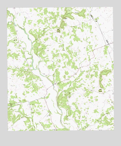
Rumley, TX USGS Topographic Map
Click on map above to begin viewing in our Map Viewer.

This topographic map contains these locations and features:
Feature Name Type Latitude Longitude GNIS ID View Map
Bear BranchStreamN31.2141°W98.0956°1372430View Map
Belton GapGapN31.2385°W98.0556°1351860View Map
Burleson BranchStreamN31.1879°W98.0942°1353327View Map
Clay Rock ChurchChurchN31.1404°W98.0750°1354590View Map
Crawford MountainSummitN31.1654°W98.0172°1355329View Map
Fall CreekStreamN31.1560°W98.0667°1357205View Map
Franklin MountainSummitN31.2468°W98.0511°1357686View Map
Garner CemeteryCemeteryN31.1829°W98.0830°1357893View Map
Groves CemeteryCemeteryN31.1524°W98.1206°1358474View Map
Grundyville ChurchChurchN31.1263°W98.0689°1358477View Map
Midway ChurchChurchN31.2357°W98.0186°1362802View Map
Picnic SpringSpringN31.1532°W98.0034°1365166View Map
Rock Church CemeteryCemeteryN31.1591°W98.0545°1366636View Map
Round MountainSummitN31.2266°W98.0636°1366943View Map
RumleyPopulated PlaceN31.1729°W98.0681°1380471View Map
School CreekStreamN31.2368°W98.1173°1376038View Map
School Creek ChurchChurchN31.2174°W98.1173°1367841View Map
Smith CemeteryCemeteryN31.2263°W98.1142°1368465View Map
Worrell AirportAirportN31.1807°W98.0751°1387001View Map

Note: Coordinates in the location and feature list above are referenced to NAD83 datum.


Copyright (C) 2008-2024 Ryan Niemi / Sunset Dynamics ... All Rights Reserved