TopoQuest Logo
Do you find TopoQuest useful?
Help keep TopoQuest running and adding new maps/features by donating!
Bitcoin:  19c7KJd3qBynnjoSw5npx9KScwjBe4ifkT
Litecoin:  LXs6TkuXGGXo1vDsWCkWVdjQX94eUKd6ui
Home View Maps Find Maps Find Places Resources & Links


Lanier, Texas Topographic Map

USGS Map Title: Lanier, TX
USGS Map MRC: 32094H3
DRG (GeoTIFF) Download: o32094h3.tif


Neighboring USGS Topographic Map Quads:


  Carterville, TX  
33094A4
 

  Linden, TX  
33094A3
 

  Atlanta South, TX  
33094A2
 

  Cunningham Creek, TX  
32094H4
 

  Lanier, TX  
32094H3
 

  Kildare, TX  
32094H2
 

  Kellyville, TX  
32094G4
 

  Jefferson, TX  
32094G3
 

  Smithland, TX  
32094G2


Map MRC Location:

N33°
W95°
N33°
W94°
H8 H7 H6 H5 H4 H3 H2 H1
G8 G7 G6 G5 G4 G3 G2 G1
F8 F7 F6 F5 F4 F3 F2 F1
E8 E7 E6 E5 E4 E3 E2 E1
D8 D7 D6 D5 D4 D3 D2 D1
C8 C7 C6 C5 C4 C3 C2 C1
B8 B7 B6 B5 B4 B3 B2 B1
A8 A7 A6 A5 A4 A3 A2 A1
N32°
W95°
N32°
W94°

Lanier, TX USGS 1:24K Topographic Map Preview:
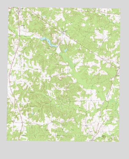
Lanier, TX USGS Topographic Map
Click on map above to begin viewing in our Map Viewer.

This topographic map contains these locations and features:
Feature Name Type Latitude Longitude GNIS ID View Map
Beach CreekStreamN32.9724°W94.3355°1330182View Map
Center Hill CemeteryCemeteryN32.9957°W94.2621°1332529View Map
Center Hill ChurchChurchN32.9801°W94.3132°1332531View Map
Center Hill Volunteer Fire DepartmentBuildingN32.9968°W94.2825°2655533View Map
Ebenezer ChurchChurchN32.8893°W94.2855°1335065View Map
EvansPopulated PlaceN32.9412°W94.2527°1378275View Map
Fairview High SchoolSchoolN32.9832°W94.3594°1335648View Map
Friendship ChurchChurchN32.9360°W94.3727°1336241View Map
Friendship Oil FieldOilfieldN32.8996°W94.3110°1336247View Map
Hall Lake Number 1ReservoirN32.9777°W94.2977°1855006View Map
Hall Lake Number 1 DamDamN32.9801°W94.2952°1855005View Map
Hall Lake Number 2ReservoirN32.9603°W94.3106°1855004View Map
Hall Lake Number 2 DamDamN32.9585°W94.3102°1855003View Map
Iron Ore LakeReservoirN32.9653°W94.3258°1338499View Map
Iron Ore Lake DamDamN32.9618°W94.3202°1855007View Map
Kouffman BranchStreamN32.9115°W94.3232°1339229View Map
LanierPopulated PlaceN32.9354°W94.3738°1378558View Map
Linden DivisionCivilN32.9912°W94.3489°1938924View Map
Linden East Oil FieldOilfieldN32.9757°W94.2849°1339965View Map
Linden-Kildare High SchoolSchoolN32.9785°W94.3121°1339966View Map
LodiPopulated PlaceN32.8762°W94.2796°1378592View Map
Lodi Post OfficePost OfficeN32.8767°W94.2794°2731423View Map
Mount Pilgrim ChurchChurchN32.8837°W94.2830°1342090View Map
Mount Zion ChurchChurchN32.8849°W94.3296°1342154View Map
PruettPopulated PlaceN32.8918°W94.3580°1388198View Map
Salem BranchStreamN32.9746°W94.3466°1346156View Map
Salem CemeteryCemeteryN32.9568°W94.3657°1346164View Map
Salem ChurchChurchN32.9554°W94.3624°1346171View Map
SheffieldPopulated PlaceN32.9368°W94.2538°1379067View Map
Shiloh ChurchChurchN32.8929°W94.3677°1347058View Map
Sunrise ChurchChurchN32.9935°W94.3491°1348080View Map
Wilburn CreekStreamN32.9112°W94.2641°1350051View Map
Zion Hill CemeteryCemeteryN32.9762°W94.3132°1350755View Map
Zion Hill ChurchChurchN32.9354°W94.3266°1350763View Map

Note: Coordinates in the location and feature list above are referenced to NAD83 datum.


Copyright (C) 2008-2024 Ryan Niemi / Sunset Dynamics ... All Rights Reserved