TopoQuest Logo
Do you find TopoQuest useful?
Help keep TopoQuest running and adding new maps/features by donating!
Bitcoin:  19c7KJd3qBynnjoSw5npx9KScwjBe4ifkT
Litecoin:  LXs6TkuXGGXo1vDsWCkWVdjQX94eUKd6ui
Home View Maps Find Maps Find Places Resources & Links


Lavaca, Arkansas Topographic Map

USGS Map Title: Lavaca, AR
USGS Map MRC: 35094C2
DRG (GeoTIFF) Download: o35094c2.tif


Neighboring USGS Topographic Map Quads:


  Van Buren, AR  
35094D3
 

  Alma, AR  
35094D2
 

  Mulberry, AR  
35094D1
 

  Barling, AR  
35094C3
 

  Lavaca, AR  
35094C2
 

  Charleston, AR  
35094C1
 

  Greenwood, AR  
35094B3
 

  Burnville, AR  
35094B2
 

  Barber, AR  
35094B1


Map MRC Location:

N36°
W95°
N36°
W94°
H8 H7 H6 H5 H4 H3 H2 H1
G8 G7 G6 G5 G4 G3 G2 G1
F8 F7 F6 F5 F4 F3 F2 F1
E8 E7 E6 E5 E4 E3 E2 E1
D8 D7 D6 D5 D4 D3 D2 D1
C8 C7 C6 C5 C4 C3 C2 C1
B8 B7 B6 B5 B4 B3 B2 B1
A8 A7 A6 A5 A4 A3 A2 A1
N35°
W95°
N35°
W94°

Lavaca, AR USGS 1:24K Topographic Map Preview:
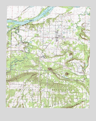
Lavaca, AR USGS Topographic Map
Click on map above to begin viewing in our Map Viewer.

This topographic map contains these locations and features:
Feature Name Type Latitude Longitude GNIS ID View Map
Arrowhead Assault StripAirportN35.2781°W94.2248°2650796View Map
Auburn (historical)Populated PlaceN35.2545°W94.1299°67190View Map
Big Creek Fire Department Station 1BuildingN35.3514°W94.1724°2116148View Map
Biswell HillSummitN35.2779°W94.2247°46649View Map
BloomerPopulated PlaceN35.2940°W94.1388°57394View Map
Bloomer Baptist ChurchChurchN35.2934°W94.1385°67195View Map
Bloomer Gas FieldOilfieldN35.3126°W94.1610°67196View Map
Bloomer RidgeRidgeN35.3093°W94.1458°46723View Map
Bloomer SchoolSchoolN35.2987°W94.1488°46724View Map
Butlers KnobSummitN35.2981°W94.1849°57482View Map
Butlers RidgeRidgeN35.2837°W94.1491°47240View Map
Carnis Auburn Road CemeteryCemeteryN35.2554°W94.1783°56759View Map
Center Valley CemeteryCemeteryN35.2876°W94.1344°56765View Map
Central City Fire StationBuildingN35.3263°W94.2399°2116253View Map
Central City Police DepartmentBuildingN35.3257°W94.2396°2118921View Map
Christmas KnobSummitN35.2923°W94.1597°57550View Map
City of LavacaCivilN35.3349°W94.1797°2404893View Map
Cox CreekStreamN35.3543°W94.1455°48128View Map
Crouch LakeReservoirN35.3129°W94.1530°80689View Map
Crouch Pond Number Two DamDamN35.3134°W94.1519°80688View Map
Diamond GrovePopulated PlaceN35.3120°W94.1988°57653View Map
Doctors CreekStreamN35.3659°W94.1297°48541View Map
Ewing Gas FieldOilfieldN35.3568°W94.1466°67250View Map
First Baptist Church of LavacaChurchN35.3365°W94.1738°67214View Map
Flat Rock CreekStreamN35.3168°W94.2169°49114View Map
Flying W Air Park IncAirportN35.3253°W94.1873°2650730View Map
Fort Chaffee Maneuver Training CenterMilitaryN35.2739°W94.1990°2512190View Map
Frustee Bend CutoffChannelN35.3718°W94.1827°49279View Map
Hill CemeteryCemeteryN35.3126°W94.2391°56767View Map
Inoian CemeteryCemeteryN35.3054°W94.2271°56766View Map
Jones CemeteryCemeteryN35.2620°W94.1441°56758View Map
LavacaPopulated PlaceN35.3362°W94.1733°77456View Map
Lavaca Elementary SchoolSchoolN35.3306°W94.1709°67236View Map
Lavaca Fire and Rescue AmbulanceBuildingN35.3357°W94.1752°2119121View Map
Lavaca Fire Department and RescueBuildingN35.3357°W94.1752°2116701View Map
Lavaca Gas FieldOilfieldN35.3487°W94.1949°67238View Map
Lavaca High SchoolSchoolN35.3319°W94.1750°67237View Map
Lavaca Middle SchoolSchoolN35.3331°W94.1737°2039148View Map
Lavaca Police DepartmentBuildingN35.3354°W94.1752°2118922View Map
Little Vache Grasse CreekStreamN35.3520°W94.2283°51334View Map
Marietta CemeteryCemeteryN35.2870°W94.1338°51669View Map
Mayberry CemeteryCemeteryN35.3179°W94.2219°51757View Map
Measles Memorial CemeteryCemeteryN35.3356°W94.1685°56768View Map
Morris CemeteryCemeteryN35.2951°W94.1294°52217View Map
Mosark ChurchChurchN35.3609°W94.1674°52229View Map
New HaroldtonPopulated PlaceN35.3709°W94.2422°58255View Map
Number Name LakeReservoirN35.3583°W94.1258°81119View Map
Number Name Lake DamDamN35.3601°W94.1252°81118View Map
Oak Valley CemeteryCemeteryN35.2912°W94.2002°56762View Map
Red Oak CemeteryCemeteryN35.3509°W94.1641°53955View Map
Speegle CemeteryCemeteryN35.2868°W94.1344°56764View Map
Town of Central CityCivilN35.3300°W94.2347°2406247View Map
Township of Big CreekCivilN35.3443°W94.1804°69102View Map
Township of Nat Osborn (historical)CivilN35.2668°W94.1877°67247View Map
Unorganized Territory of Fort ChaffeeCivilN35.2590°W94.1941°69108View Map
Vache Grasse CreekStreamN35.3476°W94.2377°55867View Map
Vache Grasse Public Use AreaParkN35.3429°W94.2308°78639View Map
Ward CemeteryCemeteryN35.2793°W94.1260°56763View Map
William Teague CemeteryCemeteryN35.2762°W94.1783°56760View Map
William Teague CemeteryCemeteryN35.2762°W94.2046°56761View Map

Note: Coordinates in the location and feature list above are referenced to NAD83 datum.


Copyright (C) 2008-2024 Ryan Niemi / Sunset Dynamics ... All Rights Reserved