TopoQuest Logo
Do you find TopoQuest useful?
Help keep TopoQuest running and adding new maps/features by donating!
Bitcoin:  19c7KJd3qBynnjoSw5npx9KScwjBe4ifkT
Litecoin:  LXs6TkuXGGXo1vDsWCkWVdjQX94eUKd6ui
Home View Maps Find Maps Find Places Resources & Links


Lovington, New Mexico Topographic Map

USGS Map Title: Lovington, NM
USGS Map MRC: 32103H3
DRG (GeoTIFF) Download: o32103h3.tif


Neighboring USGS Topographic Map Quads:


  Hillburn City SW, NM  
33103A4
 

  Hillburn City, NM  
33103A3
 

  Prairieview, NM  
33103A2
 

  Lovington NW, NM  
32103H4
 

  Lovington, NM  
32103H3
 

  Humble City NW, NM  
32103H2
 

  Lovington SW, NM  
32103G4
 

  Lovington SE, NM  
32103G3
 

  Humble City, NM  
32103G2


Map MRC Location:

N33°
W104°
N33°
W103°
H8 H7 H6 H5 H4 H3 H2 H1
G8 G7 G6 G5 G4 G3 G2 G1
F8 F7 F6 F5 F4 F3 F2 F1
E8 E7 E6 E5 E4 E3 E2 E1
D8 D7 D6 D5 D4 D3 D2 D1
C8 C7 C6 C5 C4 C3 C2 C1
B8 B7 B6 B5 B4 B3 B2 B1
A8 A7 A6 A5 A4 A3 A2 A1
N32°
W104°
N32°
W103°

Lovington, NM USGS 1:24K Topographic Map Preview:
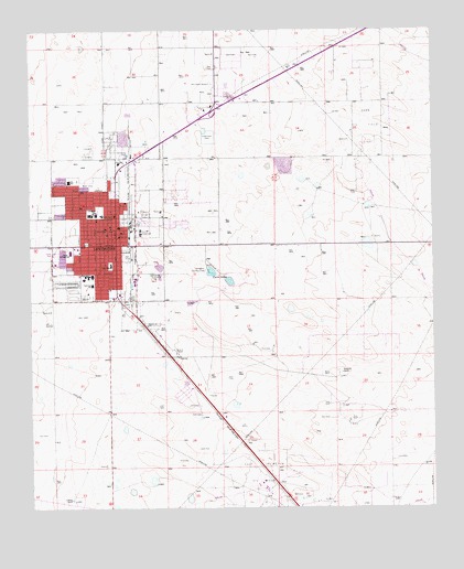
Lovington, NM USGS Topographic Map
Click on map above to begin viewing in our Map Viewer.

This topographic map contains these locations and features:
Feature Name Type Latitude Longitude GNIS ID View Map
Alexander Elementary SchoolSchoolN32.9440°W103.3486°933877View Map
Church of ChristChurchN32.9440°W103.3486°920281View Map
Church of GodChurchN32.9440°W103.3486°920251View Map
Church of the NazareneChurchN32.9440°W103.3486°920282View Map
City of LovingtonCivilN32.9516°W103.3498°2410888View Map
Collier Open PitMineN32.9721°W103.3366°914574View Map
East Lovington Oil FieldOilfieldN32.8837°W103.3055°928927View Map
First Assembly of God ChurchChurchN32.9440°W103.3486°921165View Map
First Baptist ChurchChurchN32.9440°W103.3486°921234View Map
First Christian ChurchChurchN32.9440°W103.3486°920253View Map
Gospel Lighthouse ChurchChurchN32.9440°W103.3486°920284View Map
Graham RanchLocaleN32.8773°W103.3627°889524View Map
Hillcrest Baptist ChurchChurchN32.9440°W103.3486°920983View Map
Jackson Avenue Baptist ChurchChurchN32.9440°W103.3486°921250View Map
KLEA-AM (Lovington)TowerN32.9418°W103.3205°938606View Map
KLEA-FM (Lovington)TowerN32.9418°W103.3205°938682View Map
Lea County Courthouse Historic SiteBuildingN32.9440°W103.3486°934354View Map
Lea County MuseumBuildingN32.9440°W103.3486°929499View Map
Lea County Sheriff's Office LovingtonBuildingN32.9338°W103.3411°2722540View Map
Lea Elementary SchoolSchoolN32.9440°W103.3486°933837View Map
Lea SchoolSchoolN32.9610°W103.3633°891006View Map
Llano Elementary SchoolSchoolN32.9440°W103.3486°933900View Map
Llano SchoolSchoolN32.9387°W103.3502°891221View Map
Love Street Baptist ChurchChurchN32.9440°W103.3486°920985View Map
LovingtonPopulated PlaceN32.9440°W103.3486°899742View Map
Lovington CemeteryCemeteryN32.9684°W103.3569°891409View Map
Lovington Country ClubLocaleN32.9376°W103.3211°928982View Map
Lovington Fire DepartmentBuildingN32.9469°W103.3471°2657694View Map
Lovington High SchoolSchoolN32.9440°W103.3486°901374View Map
Lovington Historical MarkerParkN32.9440°W103.3486°932290View Map
Lovington Junior High SchoolSchoolN32.9440°W103.3486°934206View Map
Lovington Police DepartmentBuildingN32.9465°W103.3471°2722558View Map
Lovington Post OfficePost OfficeN32.9444°W103.3471°938250View Map
Lovington Weather StationLocaleN32.9440°W103.3458°931876View Map
Montieth RanchLocaleN32.9107°W103.2794°892178View Map
Nor- Lea General HospitalHospitalN32.9654°W103.3478°901336View Map
Our Savior Lutheran ChurchChurchN32.9440°W103.3486°920252View Map
Parkview SchoolSchoolN32.9337°W103.3561°893096View Map
Primera Iglesia BautistaChurchN32.9440°W103.3486°921233View Map
Resthaven CemeteryCemeteryN32.9861°W103.3186°893871View Map
Taylor Junior High SchoolSchoolN32.9415°W103.3627°895533View Map
Taylor Middle SchoolSchoolN32.9440°W103.3486°901375View Map
The Church of Latter Day SaintsChurchN32.9440°W103.3486°920254View Map
Town and Country Shopping CenterLocaleN32.9579°W103.3491°901099View Map
Trinity Baptist ChurchChurchN32.9440°W103.3486°920984View Map
Twin LakesReservoirN32.9369°W103.3194°895948View Map
United Pentecostal ChurchChurchN32.9440°W103.3486°920283View Map
Victory Baptist ChurchChurchN32.9440°W103.3486°921235View Map
Yarbro Elementary SchoolSchoolN32.9440°W103.3486°933836View Map

Note: Coordinates in the location and feature list above are referenced to NAD83 datum.


Copyright (C) 2008-2024 Ryan Niemi / Sunset Dynamics ... All Rights Reserved