TopoQuest Logo
Do you find TopoQuest useful?
Help keep TopoQuest running and adding new maps/features by donating!
Bitcoin:  19c7KJd3qBynnjoSw5npx9KScwjBe4ifkT
Litecoin:  LXs6TkuXGGXo1vDsWCkWVdjQX94eUKd6ui
Home View Maps Find Maps Find Places Resources & Links


McHenry, Maryland Topographic Map

USGS Map Title: McHenry, MD
USGS Map MRC: 39079E3
DRG (GeoTIFF) Download: o39079e3.tif


Neighboring USGS Topographic Map Quads:


  Friendsville, MD  
39079F4
 

  Accident, MD  
39079F3
 

  Grantsville, MD  
39079F2
 

  Sang Run, MD  
39079E4
 

  McHenry, MD  
39079E3
 

  Bittinger, MD  
39079E2
 

  Oakland, MD  
39079D4
 

  Deer Park, MD  
39079D3
 

  Kitzmiller, MD  
39079D2


Map MRC Location:

N40°
W80°
N40°
W79°
H8 H7 H6 H5 H4 H3 H2 H1
G8 G7 G6 G5 G4 G3 G2 G1
F8 F7 F6 F5 F4 F3 F2 F1
E8 E7 E6 E5 E4 E3 E2 E1
D8 D7 D6 D5 D4 D3 D2 D1
C8 C7 C6 C5 C4 C3 C2 C1
B8 B7 B6 B5 B4 B3 B2 B1
A8 A7 A6 A5 A4 A3 A2 A1
N39°
W80°
N39°
W79°

McHenry, MD USGS 1:24K Topographic Map Preview:
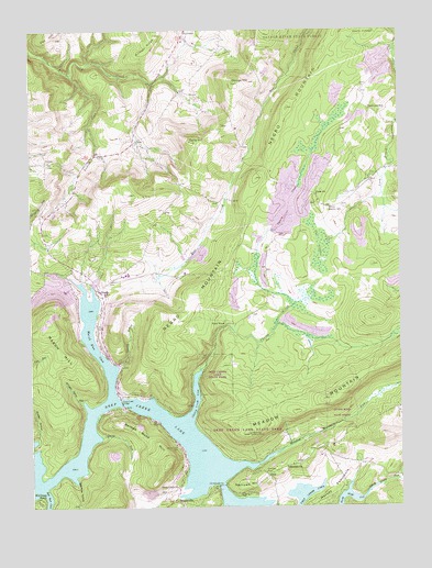
McHenry, MD USGS Topographic Map
Click on map above to begin viewing in our Map Viewer.

This topographic map contains these locations and features:
Feature Name Type Latitude Longitude GNIS ID View Map
Arrowhead RunStreamN39.5029°W79.3260°2786696View Map
Beachy SchoolSchoolN39.5781°W79.2734°583075View Map
Bee Tree HollowValleyN39.5079°W79.3610°583127View Map
Brushy HollowValleyN39.5181°W79.3732°583448View Map
Callis HillSummitN39.5959°W79.3203°583546View Map
Casselman SchoolSchoolN39.6040°W79.2598°583613View Map
Cherry CreekStreamN39.5356°W79.3178°583714View Map
Cherry Creek CoveBayN39.5284°W79.3189°583716View Map
Deep Creek BridgeBridgeN39.5279°W79.3448°584056View Map
Deep Creek CemeteryCemeteryN39.5159°W79.3253°584057View Map
Deep Creek ChurchChurchN39.5051°W79.3256°584058View Map
Deep Creek Volunteer Fire Company Station 30BuildingN39.5559°W79.3518°2580582View Map
Deep Creek Volunteer Fire DepartmentBuildingN39.5559°W79.3514°1953588View Map
District 6, Sang RunCivilN39.5537°W79.3730°1929660View Map
Garrett CollegeSchoolN39.5609°W79.3430°1711059View Map
Garrett CountyCivilN39.5289°W79.2730°1711058View Map
Garrett County AirportAirportN39.5817°W79.3378°595329View Map
George HillSummitN39.6112°W79.3059°584568View Map
Glade ChurchChurchN39.5818°W79.2781°584602View Map
Glendale BridgeBridgeN39.5056°W79.3109°584621View Map
Glendale CemeteryCemeteryN39.5087°W79.2950°584622View Map
Glendale ChurchChurchN39.5104°W79.2889°584623View Map
Gravelly RunStreamN39.5373°W79.3453°584699View Map
Harvey PeninsulaCapeN39.5043°W79.2734°584892View Map
Hickory RidgeRidgeN39.6239°W79.3322°584954View Map
HoyesPopulated PlaceN39.5904°W79.3695°588674View Map
Hoyes CemeteryCemeteryN39.5906°W79.3681°1711066View Map
Hoyes United Methodist ChurchChurchN39.5906°W79.3684°1711069View Map
Marsh HillSummitN39.5487°W79.3695°590747View Map
Marsh Run CoveBayN39.5437°W79.3545°585705View Map
Maryland State Police Barrack W McHenryBuildingN39.5742°W79.3720°2733384View Map
McComas BeachPopulated PlaceN39.5018°W79.3731°590770View Map
McHenryPopulated PlaceN39.5584°W79.3528°585763View Map
McHenry Post OfficePost OfficeN39.5558°W79.3521°1711082View Map
Meadow Mountain RunStreamN39.5151°W79.2900°585779View Map
Narrows HillSummitN39.5054°W79.3009°590863View Map
North Glade RunStreamN39.5040°W79.2611°586234View Map
Northern Garrett County Rescue Squad Station 2BuildingN39.5742°W79.3726°2639994View Map
Pleasant Valley RunStreamN39.5818°W79.2556°586599View Map
Red Run CoveBayN39.5026°W79.3698°586791View Map
Rock HouseBuildingN39.5481°W79.3092°586877View Map
Rocklick CreekStreamN39.6134°W79.3609°586899View Map
Roman Nose HillSummitN39.5112°W79.3292°591178View Map
Shingle Camp HollowValleyN39.5280°W79.3579°587338View Map
Smith RunStreamN39.5184°W79.3512°587403View Map
Thayer State Game RefugeParkN39.5359°W79.3120°587732View Map
ThayervillePopulated PlaceN39.5018°W79.3267°591400View Map
Thayerville Lookout TowerTowerN39.5193°W79.3014°592465View Map
The GladesSwampN39.5677°W79.2776°587746View Map

Note: Coordinates in the location and feature list above are referenced to NAD83 datum.


Copyright (C) 2008-2024 Ryan Niemi / Sunset Dynamics ... All Rights Reserved