TopoQuest Logo
Do you find TopoQuest useful?
Help keep TopoQuest running and adding new maps/features by donating!
Bitcoin:  19c7KJd3qBynnjoSw5npx9KScwjBe4ifkT
Litecoin:  LXs6TkuXGGXo1vDsWCkWVdjQX94eUKd6ui
Home View Maps Find Maps Find Places Resources & Links


Friendsville, Maryland Topographic Map

USGS Map Title: Friendsville, MD
USGS Map MRC: 39079F4
DRG (GeoTIFF) Download: o39079f4.tif


Neighboring USGS Topographic Map Quads:


  Fort Necessity, PA  
39079G5
 

  Ohiopyle, PA  
39079G4
 

  Confluence, PA  
39079G3
 

  Brandonville, WV  
39079F5
 

  Friendsville, MD  
39079F4
 

  Accident, MD  
39079F3
 

  Cuzzart, WV  
39079E5
 

  Sang Run, MD  
39079E4
 

  McHenry, MD  
39079E3


Map MRC Location:

N40°
W80°
N40°
W79°
H8 H7 H6 H5 H4 H3 H2 H1
G8 G7 G6 G5 G4 G3 G2 G1
F8 F7 F6 F5 F4 F3 F2 F1
E8 E7 E6 E5 E4 E3 E2 E1
D8 D7 D6 D5 D4 D3 D2 D1
C8 C7 C6 C5 C4 C3 C2 C1
B8 B7 B6 B5 B4 B3 B2 B1
A8 A7 A6 A5 A4 A3 A2 A1
N39°
W80°
N39°
W79°

Friendsville, MD USGS 1:24K Topographic Map Preview:
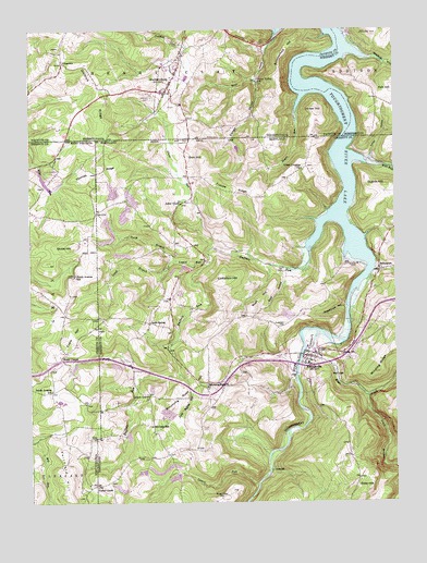
Friendsville, MD USGS Topographic Map
Click on map above to begin viewing in our Map Viewer.

This topographic map contains these locations and features:
Feature Name Type Latitude Longitude GNIS ID View Map
Appalachian LakeReservoirN39.7101°W79.4947°1558433View Map
Asher GladePopulated PlaceN39.7040°W79.4473°588611View Map
Asher Glade CemeteryCemeteryN39.7048°W79.4442°1711027View Map
Asher Glade Church of the BrethrenChurchN39.7042°W79.4484°1711028View Map
Asher Glade School (historical)SchoolN39.7045°W79.4478°1711029View Map
Bear CreekStreamN39.6704°W79.4011°583086View Map
Blooming RosePopulated PlaceN39.6567°W79.4392°1711036View Map
Blooming Rose CemeteryCemeteryN39.6562°W79.4398°1711037View Map
Blooming Rose ChurchChurchN39.6554°W79.4392°583293View Map
Blooming Rose HillSummitN39.6501°W79.4531°595632View Map
Borough of MarkleysburgCivilN39.7363°W79.4517°1215231View Map
Braddocks RunStreamN39.7426°W79.3825°1170126View Map
Buffalo RunStreamN39.6915°W79.4045°1536656View Map
Buffalo RunStreamN39.6906°W79.4039°583468View Map
Caney ValleyValleyN39.7364°W79.4217°583585View Map
Caney Valley SchoolSchoolN39.7365°W79.4211°1192236View Map
Collier HollowValleyN39.7161°W79.3835°583845View Map
Collier RunStreamN39.7145°W79.3845°1711042View Map
District 2, FriendsvilleCivilN39.6706°W79.4143°1929530View Map
Division RidgeRidgeN39.7351°W79.4759°1192363View Map
Emberson CemeteryCemeteryN39.6717°W79.4148°584294View Map
Emberson HillSummitN39.6837°W79.4328°590158View Map
Evans HillSummitN39.6715°W79.4837°1554417View Map
FiketownPopulated PlaceN39.7412°W79.4884°1174745View Map
Frazee RidgeRidgeN39.7083°W79.4355°584494View Map
FriendsvillePopulated PlaceN39.6637°W79.4053°584517View Map
Friendsville Elementary SchoolSchoolN39.6658°W79.4052°1711057View Map
Friendsville Post OfficePost OfficeN39.6643°W79.4051°2780892View Map
Friendsville Volunteer Fire Department Station 110BuildingN39.6645°W79.4030°1953594View Map
Geices (historical)Populated PlaceN39.7073°W79.3886°1711060View Map
Glade RunStreamN39.6925°W79.4377°584606View Map
Grantsville Volunteer Fire DepartmentBuildingN39.6967°W79.4078°1953627View Map
Gravel HillPopulated PlaceN39.6640°W79.3931°590356View Map
Great Crossing ChurchChurchN39.7131°W79.4061°584723View Map
Great Crossings CemeteryCemeteryN39.7128°W79.4064°1711064View Map
Guard Post Office (historical)Post OfficeN39.7142°W79.3892°1711065View Map
Guards HillSummitN39.7087°W79.3773°590394View Map
Gum HillSummitN39.7165°W79.4395°590396View Map
Juergensen Airpark and Maritime FacilityAirportN39.7319°W79.3750°2443003View Map
Keeler GladePopulated PlaceN39.6298°W79.4778°1549769View Map
Keeler GladeLocaleN39.6295°W79.4778°585284View Map
Kemp Farm Pond DamDamN39.7184°W79.4298°594546View Map
KendallPopulated PlaceN39.6334°W79.4175°590587View Map
Laurel RunStreamN39.6876°W79.4392°585369View Map
Laurel RunStreamN39.6301°W79.4223°585372View Map
Laurel RunStreamN39.6301°W79.4220°1541492View Map
Little Buffalo RunStreamN39.6590°W79.4492°585440View Map
Locust GrovePopulated PlaceN39.6534°W79.4595°585537View Map
MarkleysburgPopulated PlaceN39.7331°W79.4528°1180428View Map
Markleysburg Henry Clay Volunteer Fire Department Main Station 27BuildingN39.7415°W79.4484°2645761View Map
Markleysburg Post OfficePost OfficeN39.7369°W79.4504°2772819View Map
McCabe SchoolSchoolN39.6451°W79.4587°585752View Map
Mill RunStreamN39.7142°W79.3839°585879View Map
North Avenue School (historical)SchoolN39.6851°W79.4848°1544196View Map
North Branch Laurel RunStreamN39.6884°W79.4495°586217View Map
Northern Garrett County Rescue Squad Station 3BuildingN39.6631°W79.4062°2639995View Map
Peppermint HollowValleyN39.6766°W79.3922°586468View Map
Pinkham RunStreamN39.7451°W79.4450°1183949View Map
Polk HillSummitN39.7340°W79.3753°1184207View Map
Reason RunStreamN39.7279°W79.4078°1184740View Map
Reason RunStreamN39.7281°W79.4081°586780View Map
River View HillSummitN39.6262°W79.4334°591139View Map
Rush Baptist ChurchChurchN39.6745°W79.4259°1711097View Map
Rush HillSummitN39.6762°W79.4239°591201View Map
Rush HollowValleyN39.6848°W79.4119°586966View Map
Sand SpringPopulated PlaceN39.6726°W79.4595°591224View Map
Sand Spring CemeteryCemeteryN39.6712°W79.4595°1711102View Map
Sand Spring School (historical)SchoolN39.6729°W79.4592°1711103View Map
Selbys Port United Methodist ChurchChurchN39.6867°W79.3809°1711106View Map
SelbysportPopulated PlaceN39.6865°W79.3803°587265View Map
Sickle HillSummitN39.6929°W79.4848°1555622View Map
South Avenue School (historical)SchoolN39.6545°W79.4928°1547062View Map
South Branch Bear CreekStreamN39.6531°W79.3845°587449View Map
South Branch Laurel RunStreamN39.6881°W79.4492°587452View Map
South Branch Laurel RunStreamN39.6881°W79.4498°1547066View Map
Speelman Mills (historical)LocaleN39.7142°W79.3848°1711109View Map
Steel CemeteryCemeteryN39.6651°W79.4003°1711112View Map
Stony RunStreamN39.6579°W79.4625°1547500View Map
Stony RunStreamN39.6576°W79.4625°587589View Map
Stuck HollowValleyN39.7449°W79.4187°1188894View Map
Summerfield HillSummitN39.7448°W79.4109°1189025View Map
Thomas CemeteryCemeteryN39.7322°W79.4580°1189473View Map
Thomas RidgeRidgeN39.7142°W79.4707°587773View Map
Town of FriendsvilleCivilN39.6630°W79.4045°2390193View Map
Umber HillSummitN39.7279°W79.4000°1190076View Map
United States Prison HazletonBuildingN39.6729°W79.4971°2634728View Map
Watsondale (historical)Populated PlaceN39.7259°W79.3900°1201498View Map
Webb Chapel CemeteryCemeteryN39.6648°W79.4916°2586231View Map
Webb Chapel United Methodist ChurchChurchN39.6640°W79.4898°1548866View Map

Note: Coordinates in the location and feature list above are referenced to NAD83 datum.


Copyright (C) 2008-2024 Ryan Niemi / Sunset Dynamics ... All Rights Reserved