TopoQuest Logo
Do you find TopoQuest useful?
Help keep TopoQuest running and adding new maps/features by donating!
Bitcoin:  19c7KJd3qBynnjoSw5npx9KScwjBe4ifkT
Litecoin:  LXs6TkuXGGXo1vDsWCkWVdjQX94eUKd6ui
Home View Maps Find Maps Find Places Resources & Links


McLaurin, Mississippi Topographic Map

USGS Map Title: McLaurin, MS
USGS Map MRC: 31089B2
DRG (GeoTIFF) Download: o31089b2.tif


Neighboring USGS Topographic Map Quads:


  Hattiesburg, MS  
31089C3
 

  Carterville, MS  
31089C2
 

  Ovett SE, MS  
31089C1
 

  Dixie, MS  
31089B3
 

  McLaurin, MS  
31089B2
 

  New Augusta, MS  
31089B1
 

  Rock Hill, MS  
31089A3
 

  Brooklyn, MS  
31089A2
 

  Janice, MS  
31089A1


Map MRC Location:

N32°
W90°
N32°
W89°
H8 H7 H6 H5 H4 H3 H2 H1
G8 G7 G6 G5 G4 G3 G2 G1
F8 F7 F6 F5 F4 F3 F2 F1
E8 E7 E6 E5 E4 E3 E2 E1
D8 D7 D6 D5 D4 D3 D2 D1
C8 C7 C6 C5 C4 C3 C2 C1
B8 B7 B6 B5 B4 B3 B2 B1
A8 A7 A6 A5 A4 A3 A2 A1
N31°
W90°
N31°
W89°

McLaurin, MS USGS 1:24K Topographic Map Preview:
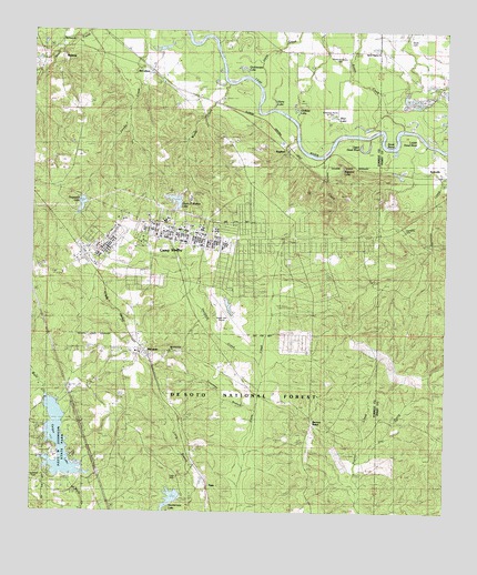
McLaurin, MS USGS Topographic Map
Click on map above to begin viewing in our Map Viewer.

This topographic map contains these locations and features:
Feature Name Type Latitude Longitude GNIS ID View Map
Barron PointPopulated PlaceN31.1474°W89.1653°692465View Map
BellevillePopulated PlaceN31.2124°W89.1264°692536View Map
Bethesda Home for GirlsBuildingN31.2285°W89.1587°706330View Map
Blue LakeLakeN31.2279°W89.1592°692646View Map
Braiden CreekStreamN31.2388°W89.2478°692687View Map
Buckeye TrailTrailN31.1302°W89.2195°705659View Map
Camp ShelbyBuildingN31.1983°W89.2111°2596808View Map
Camp Shelby Joint Forces Training Center Fire DepartmentBuildingN31.1912°W89.2329°2668029View Map
Camp Shelby Lake DamDamN31.1818°W89.2484°695362View Map
Courtney BranchStreamN31.1513°W89.1820°692993View Map
Dogwood LakeReservoirN31.2051°W89.2352°704764View Map
Dogwood Lake DamDamN31.2068°W89.2401°695364View Map
Dry ProngStreamN31.1380°W89.1506°693127View Map
Enon CemeteryCemeteryN31.2482°W89.2387°693176View Map
EppsPopulated PlaceN31.1310°W89.1959°693182View Map
Epps CemeteryCemeteryN31.1341°W89.2056°704765View Map
Garraway CemeteryCemeteryN31.1991°W89.1378°704606View Map
Garraway CreekStreamN31.2196°W89.1356°692839View Map
Geiger LakeReservoirN31.1431°W89.2418°694759View Map
Ginfield LakeLakeN31.2300°W89.1711°693299View Map
Glenn D Walker LakeReservoirN31.2059°W89.2070°704771View Map
Greenwood Water Treatment PlantLocaleN31.2382°W89.2152°2596155View Map
Hagler Army HeliportAirportN31.1791°W89.1944°2676408View Map
Harry LakeLakeN31.2315°W89.1772°693425View Map
Hartfield CreekStreamN31.1630°W89.1801°693426View Map
Helton CreekStreamN31.2182°W89.1609°704773View Map
Jakes CreekStreamN31.2293°W89.1770°693597View Map
Joe Morgan Lake DamDamN31.1285°W89.2417°695356View Map
Lake Shelby DamDamN31.1752°W89.2401°695361View Map
Lone Pine Fire TowerTowerN31.1716°W89.1526°711268View Map
Lower Dead RiverStreamN31.2196°W89.1342°693838View Map
Maneuver Training Area Camp ShelbyMilitaryN31.1878°W89.1991°2512528View Map
McCallumPopulated PlaceN31.2377°W89.2126°693904View Map
McKenzie-Myers CemeteryCemeteryN31.2424°W89.1576°704777View Map
McLaurinPopulated PlaceN31.1680°W89.2173°693929View Map
McLaurin CemeteryCemeteryN31.1666°W89.2061°709079View Map
McLaurin Landing Field (historical)AirportN31.1610°W89.2184°705622View Map
McLaurin Recreation CenterBuildingN31.1643°W89.2181°2597104View Map
McLaurin United Methodist ChurchChurchN31.1666°W89.2176°704778View Map
McLaurin Volunteer Fire Department Station 1BuildingN31.1663°W89.2183°2332768View Map
Morning Star ChurchChurchN31.1668°W89.2081°704779View Map
Morris BranchStreamN31.1530°W89.2420°694041View Map
Newman CemeteryCemeteryN31.1349°W89.2489°694198View Map
Old Enon ChurchChurchN31.2480°W89.2414°704780View Map
Paul B Johnson State ParkParkN31.1418°W89.2403°704781View Map
Quickswipe LakeLakeN31.2405°W89.1869°694498View Map
RaglandPopulated PlaceN31.2191°W89.1737°704783View Map
Ragland HillsRangeN31.2030°W89.1751°706356View Map
Ragland LakeLakeN31.2147°W89.1566°694501View Map
RalstonPopulated PlaceN31.2388°W89.2417°694504View Map
Reese CreekStreamN31.2249°W89.1456°694549View Map
Scott BendBendN31.2227°W89.1414°694729View Map
Shelby Auxiliary Field One AirportAirportN31.2049°W89.1800°2717369View Map
Sportsman Club Lake DamDamN31.1288°W89.2051°695360View Map
Sportsman LakeReservoirN31.1285°W89.2076°704786View Map
Supervisor District 4CivilN31.1978°W89.2143°711846View Map
Sweet Pilgrim ChurchChurchN31.2446°W89.1456°694915View Map
Upper Dead RiverStreamN31.2227°W89.1478°695062View Map
Wade CemeteryCemeteryN31.2480°W89.1370°705617View Map
WallisPopulated PlaceN31.1555°W89.2384°695088View Map
Walters BranchStreamN31.2207°W89.1312°704788View Map
Weldy CreekStreamN31.2368°W89.1903°695114View Map

Note: Coordinates in the location and feature list above are referenced to NAD83 datum.


Copyright (C) 2008-2024 Ryan Niemi / Sunset Dynamics ... All Rights Reserved