TopoQuest Logo
Do you find TopoQuest useful?
Help keep TopoQuest running and adding new maps/features by donating!
Bitcoin:  19c7KJd3qBynnjoSw5npx9KScwjBe4ifkT
Litecoin:  LXs6TkuXGGXo1vDsWCkWVdjQX94eUKd6ui
Home View Maps Find Maps Find Places Resources & Links


Millikin, Louisiana Topographic Map

USGS Map Title: Millikin, LA
USGS Map MRC: 32091H2
DRG (GeoTIFF) Download: o32091h2.tif


Neighboring USGS Topographic Map Quads:


  Eudora South, AR  
33091A3
 

  Readland, AR  
33091A2
 

  Glen Allan, MS  
33091A1
 

  Kilbourne, LA  
32091H3
 

  Millikin, LA  
32091H2
 

  Mayersville, MS  
32091H1
 

  Baxter Bayou, LA  
32091G3
 

  Lake Providence, LA  
32091G2
 

  Whiting Bayou, MS  
32091G1


Map MRC Location:

N33°
W92°
N33°
W91°
H8 H7 H6 H5 H4 H3 H2 H1
G8 G7 G6 G5 G4 G3 G2 G1
F8 F7 F6 F5 F4 F3 F2 F1
E8 E7 E6 E5 E4 E3 E2 E1
D8 D7 D6 D5 D4 D3 D2 D1
C8 C7 C6 C5 C4 C3 C2 C1
B8 B7 B6 B5 B4 B3 B2 B1
A8 A7 A6 A5 A4 A3 A2 A1
N32°
W92°
N32°
W91°

Millikin, LA USGS 1:24K Topographic Map Preview:
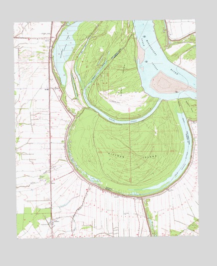
Millikin, LA USGS Topographic Map
Click on map above to begin viewing in our Map Viewer.

This topographic map contains these locations and features:
Feature Name Type Latitude Longitude GNIS ID View Map
Ashton School (historical)SchoolN32.9915°W91.2282°548840View Map
Brunett (historical)Populated PlaceN32.8971°W91.1690°548847View Map
Bunchs BendBendN32.9029°W91.1696°687582View Map
Bunchs CutoffGutN32.9412°W91.1759°667786View Map
Cottonwood AirportAirportN32.9886°W91.2026°1632826View Map
Doe LakeLakeN32.9786°W91.2034°554251View Map
GassowayPopulated PlaceN32.9898°W91.2248°541098View Map
Gassoway LakeLakeN32.9860°W91.2097°554516View Map
Jack Falls CanalCanalN32.8826°W91.1284°554849View Map
Jerusalem CemeteryCemeteryN32.8887°W91.1765°536026View Map
Jerusalem ChurchChurchN32.8990°W91.1801°536038View Map
King Solomon CemeteryCemeteryN32.8835°W91.2273°536204View Map
La Bend RevetmentLeveeN32.9557°W91.2112°549569View Map
Lebanon (historical)Populated PlaceN32.9321°W91.2262°548866View Map
Little Gassoway LakeLakeN32.9615°W91.2087°555073View Map
Louisina BendBendN32.9768°W91.2071°548869View Map
MillikinPopulated PlaceN32.9618°W91.2259°537146View Map
Mount Pleasant ChurchChurchN32.9621°W91.2221°537396View Map
Old RiverLakeN32.9073°W91.1933°555547View Map
Old RiverGutN32.9154°W91.1359°675229View Map
Old Saint Paul CemeteryCemeteryN32.9018°W91.1457°537855View Map
Opossum PointCapeN32.9543°W91.1368°537890View Map
PanolaPopulated PlaceN32.9076°W91.2259°543567View Map
Panola CemeteryCemeteryN32.9104°W91.2332°537962View Map
Pilcher PointPopulated PlaceN32.9501°W91.2001°556542View Map
Pittman IslandAreaN32.9210°W91.1707°675949View Map
Pittman IslandIslandN32.9210°W91.1698°538225View Map
Pittman Island LandingLocaleN32.9404°W91.1712°711152View Map
Poverty PointCapeN32.9457°W91.1782°711153View Map
Robertdale (historical)Populated PlaceN32.9023°W91.1448°1631270View Map
Rose Hill ChurchChurchN32.9157°W91.2251°538712View Map
Sarah CutoffChannelN32.9796°W91.1576°677409View Map
Sarah IslandAreaN32.9657°W91.1759°677410View Map
ShelburnPopulated PlaceN32.8843°W91.2257°543661View Map
Supervisor District 4CivilN32.9555°W91.1604°711893View Map
Ward FiveCivilN32.8812°W91.2329°545010View Map

Note: Coordinates in the location and feature list above are referenced to NAD83 datum.


Copyright (C) 2008-2024 Ryan Niemi / Sunset Dynamics ... All Rights Reserved