TopoQuest Logo
Do you find TopoQuest useful?
Help keep TopoQuest running and adding new maps/features by donating!
Bitcoin:  19c7KJd3qBynnjoSw5npx9KScwjBe4ifkT
Litecoin:  LXs6TkuXGGXo1vDsWCkWVdjQX94eUKd6ui
Home View Maps Find Maps Find Places Resources & Links


Monticello, Illinois Topographic Map

USGS Map Title: Monticello, IL
USGS Map MRC: 40088A5
DRG (GeoTIFF) Download: o40088a5.tif


Neighboring USGS Topographic Map Quads:


  Farmer City South, IL  
40088B6
 

  Mansfield, IL  
40088B5
 

  Mahomet, IL  
40088B4
 

  Weldon East, IL  
40088A6
 

  Monticello, IL  
40088A5
 

  Seymour, IL  
40088A4
 

  Cerro Gordo, IL  
39088H6
 

  Bement, IL  
39088H5
 

  Ivesdale, IL  
39088H4


Map MRC Location:

N41°
W89°
N41°
W88°
H8 H7 H6 H5 H4 H3 H2 H1
G8 G7 G6 G5 G4 G3 G2 G1
F8 F7 F6 F5 F4 F3 F2 F1
E8 E7 E6 E5 E4 E3 E2 E1
D8 D7 D6 D5 D4 D3 D2 D1
C8 C7 C6 C5 C4 C3 C2 C1
B8 B7 B6 B5 B4 B3 B2 B1
A8 A7 A6 A5 A4 A3 A2 A1
N40°
W89°
N40°
W88°

Monticello, IL USGS 1:24K Topographic Map Preview:
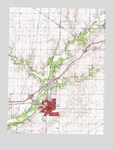
Monticello, IL USGS Topographic Map
Click on map above to begin viewing in our Map Viewer.

This topographic map contains these locations and features:
Feature Name Type Latitude Longitude GNIS ID View Map
Allerton Public LibraryBuildingN40.0261°W88.5715°1822158View Map
Buck Pond (historical)LakeN40.0695°W88.5709°1720059View Map
Bucks Pond CemeteryCemeteryN40.0695°W88.5728°1822167View Map
Calvary Baptist ChurchChurchN40.0298°W88.5803°1822168View Map
Camp CreekStreamN40.0431°W88.5762°405450View Map
Camp Creek CemeteryCemeteryN40.0686°W88.5165°405457View Map
Camp Creek School (historical)SchoolN40.0686°W88.5112°1720043View Map
Caveny FarmLocaleN40.0831°W88.5669°2556443View Map
Church of ChristChurchN40.0309°W88.5781°1822173View Map
Church of the NazareneChurchN40.0311°W88.5731°1822174View Map
City of MonticelloCivilN40.0338°W88.5730°2395384View Map
CombsPopulated PlaceN40.1195°W88.6103°422571View Map
Dighton School (historical)SchoolN40.0478°W88.5531°1720041View Map
First Baptist Church of MonticelloChurchN40.0256°W88.5684°1822177View Map
First Christian ChurchChurchN40.0392°W88.5692°1720052View Map
First Presbyterian ChurchChurchN40.0245°W88.5731°1822180View Map
First United Methodist ChurchChurchN40.0245°W88.5712°1822181View Map
Forest Preserve ParkParkN40.0395°W88.5720°1822182View Map
Goose CreekStreamN40.0517°W88.5798°409165View Map
Goose Creek Energy CenterBuildingN40.1061°W88.5989°2419853View Map
Haneline CemeteryCemeteryN40.0134°W88.5955°409737View Map
Haneline School (historical)SchoolN40.0078°W88.6062°1720049View Map
Hughes CemeteryCemeteryN40.0844°W88.5344°410662View Map
Independent School (historical)SchoolN40.0075°W88.5298°1720039View Map
Ingram CemeteryCemeteryN40.1070°W88.5006°410900View Map
Interchange 61CrossingN40.0361°W88.5965°1822184View Map
Interchange 63CrossingN40.0539°W88.5640°1822185View Map
Interchange 66CrossingN40.0820°W88.5273°1822186View Map
Kirby Hospital Ambulance ServiceBuildingN40.0604°W88.5589°2673799View Map
Kirby Medical CenterHospitalN40.0603°W88.5588°411540View Map
Lincoln Elementary SchoolSchoolN40.0303°W88.5678°412156View Map
LodgePopulated PlaceN40.1061°W88.5601°412501View Map
Lodge ParkParkN40.0664°W88.5648°412502View Map
Madden CemeteryCemeteryN40.0996°W88.5385°412818View Map
Madden CreekStreamN40.0945°W88.5401°426592View Map
Marquiss CemeteryCemeteryN40.0705°W88.5985°413032View Map
Mid Piatt County Fire Protection DistrictBuildingN40.0849°W88.5173°2682490View Map
Mid Piatt Fire Protection District MonticelloBuildingN40.0100°W88.5768°2682144View Map
MonticelloPopulated PlaceN40.0278°W88.5734°413750View Map
Monticello and Sangamon Valley Railway MuseumBuildingN40.0600°W88.5534°425207View Map
Monticello Assembly of God ChurchChurchN40.0278°W88.5684°1822195View Map
Monticello CemeteryCemeteryN40.0450°W88.5681°1720050View Map
Monticello CemeteryCemeteryN40.0422°W88.5714°413751View Map
Monticello Christian AcademySchoolN40.0256°W88.5684°1822196View Map
Monticello City HallBuildingN40.0264°W88.5715°1720055View Map
Monticello Fire and RescueBuildingN40.0269°W88.5694°2681796View Map
Monticello Fire and Rescue Training FacilityBuildingN40.0199°W88.5866°2681710View Map
Monticello Golf ClubLocaleN40.0239°W88.5834°425208View Map
Monticello High SchoolSchoolN40.0192°W88.5723°1720058View Map
Monticello Police DepartmentBuildingN40.0269°W88.5695°2758981View Map
Monticello Post OfficePost OfficeN40.0264°W88.5721°1720056View Map
Monticello Water WorksLocaleN40.0261°W88.5692°1822197View Map
Morain CemeteryCemeteryN40.0765°W88.6225°413803View Map
Piatt CountyCivilN40.0104°W88.5911°424275View Map
Piatt County AirportAirportN40.0094°W88.5583°427566View Map
Piatt County CourthouseBuildingN40.0250°W88.5726°1720057View Map
Piatt County JailBuildingN40.0261°W88.5728°1822199View Map
Piatt County Sheriff's OfficeBuildingN40.0251°W88.5724°2759052View Map
Piatt School (historical)SchoolN40.0703°W88.5984°1720046View Map
Pontious FarmLocaleN40.0769°W88.5061°2564386View Map
Ridge School (historical)SchoolN40.0250°W88.5295°1720040View Map
Saint Philomenas ChurchChurchN40.0375°W88.5742°1720054View Map
Slabtown School (historical)SchoolN40.0689°W88.5545°1720044View Map
Stringtown CemeteryCemeteryN40.0392°W88.6218°415724View Map
Stringtown School (historical)SchoolN40.0395°W88.6056°1720047View Map
Township of MonticelloCivilN40.0106°W88.5377°429390View Map
Township of SangamonCivilN40.1126°W88.5188°429711View Map
Washington Elementary SchoolCanalN40.0189°W88.5731°1822204View Map
White HeathPopulated PlaceN40.0861°W88.5128°421042View Map
White Heath Census Designated PlaceCensusN40.0868°W88.5116°2628564View Map
White Heath Elementary SchoolSchoolN40.0859°W88.5134°1822205View Map
White Heath Post OfficePost OfficeN40.0858°W88.5082°1822206View Map
Wolfe OrchardLocaleN40.0361°W88.5275°2556442View Map
Woolington CemeteryCemeteryN40.0464°W88.5803°421499View Map
WVLJ-FM (Monticello)TowerN40.0478°W88.5728°428245View Map

Note: Coordinates in the location and feature list above are referenced to NAD83 datum.


Copyright (C) 2008-2024 Ryan Niemi / Sunset Dynamics ... All Rights Reserved