TopoQuest Logo
Do you find TopoQuest useful?
Help keep TopoQuest running and adding new maps/features by donating!
Bitcoin:  19c7KJd3qBynnjoSw5npx9KScwjBe4ifkT
Litecoin:  LXs6TkuXGGXo1vDsWCkWVdjQX94eUKd6ui
Home View Maps Find Maps Find Places Resources & Links


Farmer City South, Illinois Topographic Map

USGS Map Title: Farmer City South, IL
USGS Map MRC: 40088B6
DRG (GeoTIFF) Download: o40088b6.tif


Neighboring USGS Topographic Map Quads:


  Le Roy, IL  
40088C7
 

  Farmer City North, IL  
40088C6
 

  Bellflower, IL  
40088C5
 

  De Witt, IL  
40088B7
 

  Farmer City South, IL  
40088B6
 

  Mansfield, IL  
40088B5
 

  Weldon West, IL  
40088A7
 

  Weldon East, IL  
40088A6
 

  Monticello, IL  
40088A5


Map MRC Location:

N41°
W89°
N41°
W88°
H8 H7 H6 H5 H4 H3 H2 H1
G8 G7 G6 G5 G4 G3 G2 G1
F8 F7 F6 F5 F4 F3 F2 F1
E8 E7 E6 E5 E4 E3 E2 E1
D8 D7 D6 D5 D4 D3 D2 D1
C8 C7 C6 C5 C4 C3 C2 C1
B8 B7 B6 B5 B4 B3 B2 B1
A8 A7 A6 A5 A4 A3 A2 A1
N40°
W89°
N40°
W88°

Farmer City South, IL USGS 1:24K Topographic Map Preview:
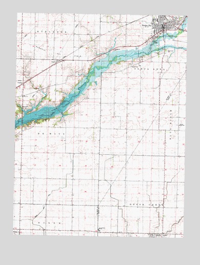
Farmer City South, IL USGS Topographic Map
Click on map above to begin viewing in our Map Viewer.

This topographic map contains these locations and features:
Feature Name Type Latitude Longitude GNIS ID View Map
Barnes CemeteryCemeteryN40.1900°W88.7287°403908View Map
Black School (historical)SchoolN40.1853°W88.6731°1719998View Map
Blue Ridge High SchoolSchoolN40.2478°W88.6470°1747767View Map
Bosserman School (historical)SchoolN40.1598°W88.7448°1719990View Map
Campground CemeteryCemeteryN40.2300°W88.6787°405530View Map
Champion School (historical)SchoolN40.1284°W88.7067°1719991View Map
City of Farmer CityCivilN40.2480°W88.6426°2394744View Map
De Land CemeteryCemeteryN40.1262°W88.6476°1822175View Map
Deland-Weldon High SchoolSchoolN40.1289°W88.6876°407102View Map
Excelsior School (historical)SchoolN40.1573°W88.7065°1719992View Map
Farmer CityPopulated PlaceN40.2434°W88.6426°408277View Map
Farmer City Ambulance ServiceBuildingN40.2437°W88.6422°2682028View Map
Farmer City CemeteryCemeteryN40.2399°W88.6448°1951260View Map
Farmer City Fire DepartmentBuildingN40.2414°W88.6410°2681975View Map
Farmer City Police DepartmentBuildingN40.2439°W88.6421°2759068View Map
Farmer City Post OfficePost OfficeN40.2432°W88.6416°1985580View Map
Farmer City Public PoolParkN40.2489°W88.6465°1985581View Map
First Baptist ChurchChurchN40.2456°W88.6406°1985577View Map
First Christian ChurchChurchN40.2439°W88.6406°1985578View Map
FullertonPopulated PlaceN40.2103°W88.7445°422721View Map
Fullerton ChurchChurchN40.2028°W88.7451°408802View Map
Greenleaf CemeteryCemeteryN40.2214°W88.6656°409435View Map
Greenleaf School (historical)SchoolN40.2184°W88.6726°1719997View Map
Maple Grove CemeteryCemeteryN40.2298°W88.6401°412922View Map
McCord CemeteryCemeteryN40.1964°W88.7439°413221View Map
Mount Vernon School (historical)SchoolN40.1559°W88.6301°1720001View Map
ParnellPopulated PlaceN40.2231°W88.7206°423056View Map
Parnell Oil FieldOilfieldN40.2267°W88.7170°425313View Map
Parnell School (historical)SchoolN40.2314°W88.7078°1719995View Map
Ruth M Schneider Elementary SchoolSchoolN40.2467°W88.6470°1808825View Map
Sacred Heart ChurchChurchN40.2489°W88.6445°1985579View Map
Saint Josephs Catholic CemeteryCemeteryN40.2285°W88.6451°417432View Map
South Prairie School (historical)SchoolN40.1856°W88.6306°1720000View Map
Swigart School (historical)SchoolN40.1873°W88.7131°1719993View Map
Township of De WittCivilN40.1833°W88.7450°428894View Map
Township of Santa AnnaCivilN40.2357°W88.6504°429713View Map
Trenkle SloughStreamN40.2281°W88.6528°426596View Map
Turner School (historical)SchoolN40.2381°W88.7470°1719994View Map
Watson School (historical)SchoolN40.2145°W88.6253°1719999View Map
Weedman ParkParkN40.2492°W88.6467°1985582View Map
Weedman School (historical)SchoolN40.2400°W88.6703°1719996View Map
Western School (historical)SchoolN40.1275°W88.6728°1720003View Map
Wisegarver School (historical)SchoolN40.1570°W88.6687°1720002View Map

Note: Coordinates in the location and feature list above are referenced to NAD83 datum.


Copyright (C) 2008-2024 Ryan Niemi / Sunset Dynamics ... All Rights Reserved