TopoQuest Logo
Do you find TopoQuest useful?
Help keep TopoQuest running and adding new maps/features by donating!
Bitcoin:  19c7KJd3qBynnjoSw5npx9KScwjBe4ifkT
Litecoin:  LXs6TkuXGGXo1vDsWCkWVdjQX94eUKd6ui
Home View Maps Find Maps Find Places Resources & Links


Mount Wilson, Colorado Topographic Map

USGS Map Title: Mount Wilson, CO
USGS Map MRC: 37107G8
DRG (GeoTIFF) Download: o37107g8.tif


Neighboring USGS Topographic Map Quads:


  Little Cone, CO  
37108H1
 

  Gray Head, CO  
37107H8
 

  Telluride, CO  
37107H7
 

  Dolores Peak, CO  
37108G1
 

  Mount Wilson, CO  
37107G8
 

  Ophir, CO  
37107G7
 

  Rico, CO  
37108F1
 

  Hermosa Peak, CO  
37107F8
 

  Engineer Mountain, CO  
37107F7


Map MRC Location:

N38°
W108°
N38°
W107°
H8 H7 H6 H5 H4 H3 H2 H1
G8 G7 G6 G5 G4 G3 G2 G1
F8 F7 F6 F5 F4 F3 F2 F1
E8 E7 E6 E5 E4 E3 E2 E1
D8 D7 D6 D5 D4 D3 D2 D1
C8 C7 C6 C5 C4 C3 C2 C1
B8 B7 B6 B5 B4 B3 B2 B1
A8 A7 A6 A5 A4 A3 A2 A1
N37°
W108°
N37°
W107°

Mount Wilson, CO USGS 1:24K Topographic Map Preview:
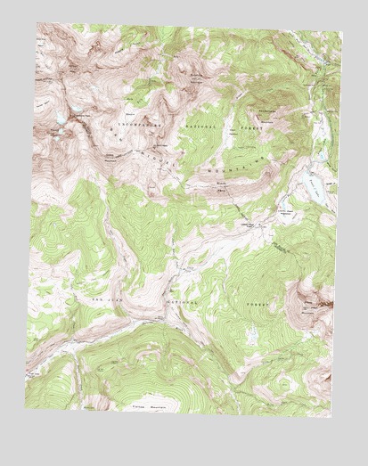
Mount Wilson, CO USGS Topographic Map
Click on map above to begin viewing in our Map Viewer.

This topographic map contains these locations and features:
Feature Name Type Latitude Longitude GNIS ID View Map
AmesPopulated PlaceN37.8647°W107.8823°187459View Map
Atlas MineMineN37.8422°W107.8920°1734798View Map
Barlow CreekStreamN37.7706°W107.9812°187489View Map
Barlow LakeReservoirN37.7510°W107.9765°187490View Map
Bilk BasinBasinN37.8492°W107.9606°187458View Map
Black FaceSummitN37.8236°W107.9217°187480View Map
Butterfly MineMineN37.8561°W107.8820°187469View Map
Butterfly MineMineN37.8561°W107.8823°1734799View Map
Calamine MineMineN37.8603°W107.8787°1734819View Map
Cayton CampgroundLocaleN37.7711°W107.9776°196915View Map
Coal CreekStreamN37.7603°W107.9995°176587View Map
Coke OvenLocaleN37.7617°W107.9984°187488View Map
Coke Oven CreekStreamN37.7711°W107.9820°187478View Map
Cross MountainSummitN37.8322°W107.9687°187476View Map
Cross Mountain TrailTrailN37.8097°W107.9901°196907View Map
East Fork TrailTrailN37.7828°W107.9356°196914View Map
Garibaldi MineMineN37.8494°W107.8795°1734800View Map
Gladstone PeakSummitN37.8453°W107.9840°187460View Map
Gold CreekStreamN37.8705°W107.8909°176415View Map
Howard ForkStreamN37.8658°W107.8840°187466View Map
Lake ForkStreamN37.8661°W107.8840°187467View Map
Lizard HeadSummitN37.8358°W107.9506°187465View Map
Lizard Head CreekStreamN37.7964°W107.9378°187481View Map
Lizard Head CreekStreamN37.8258°W107.8901°187484View Map
Lizard Head MeadowsFlatN37.8167°W107.8965°187485View Map
Lizard Head PassGapN37.8111°W107.9062°187486View Map
Lizard Head TrailTrailN37.8242°W107.9195°187479View Map
Lizard Head TrailheadLocaleN37.8128°W107.9081°196919View Map
Magpie GulchValleyN37.8707°W107.9491°187456View Map
Matterhorn CampgroundLocaleN37.8453°W107.8817°196917View Map
Matterhorn DriftsMineN37.8489°W107.8790°187470View Map
Matterhorn Work CenterLocaleN37.8428°W107.8826°196918View Map
Minnie GulchValleyN37.8333°W107.8805°187475View Map
Mount WilsonSummitN37.8392°W107.9915°187461View Map
Moyer and Tucson MineMineN37.8556°W107.8831°1734801View Map
North Twin CreekStreamN37.7592°W107.9159°187492View Map
Old Butterfly MineMineN37.8575°W107.8859°187468View Map
Ophir Loop SchoolSchoolN37.8644°W107.8751°187496View Map
Owen LakeLakeN37.8096°W107.9900°196916View Map
Priest LakesLakeN37.8350°W107.8820°187474View Map
Rock of Ages MineMineN37.8555°W107.9928°187457View Map
Rodger GulchValleyN37.8251°W107.8816°187487View Map
San Bernardo MineMineN37.8475°W107.8906°187471View Map
San Bernardo MountainSummitN37.8472°W107.9087°187472View Map
Sheep MountainSummitN37.7853°W107.8862°187491View Map
Sheep TrailTrailN37.8364°W107.9095°187473View Map
Silver Eagle MineMineN37.8544°W107.9306°1734802View Map
Silver Hat MineMineN37.8405°W107.9484°1734803View Map
Silver Pick MineMineN37.8594°W107.9998°187453View Map
Slate CreekStreamN37.7786°W107.9562°187477View Map
Snow Spur CreekStreamN37.7794°W107.9448°187482View Map
South Twin CreekStreamN37.7578°W107.9159°187493View Map
Special Session MineMineN37.8575°W107.9901°1734804View Map
Sunshine MountainSummitN37.8583°W107.9342°187462View Map
Synopsis MineMineN37.8592°W107.9909°187454View Map
Trout LakeReservoirN37.8244°W107.8849°187483View Map
Trout Lake DamDamN37.8286°W107.8878°198520View Map
Wilson CreekStreamN37.8558°W107.8887°187463View Map
Wilson MeadowsFlatN37.8419°W107.9209°187464View Map
Wilson PeakSummitN37.8603°W107.9848°187455View Map

Note: Coordinates in the location and feature list above are referenced to NAD83 datum.


Copyright (C) 2008-2024 Ryan Niemi / Sunset Dynamics ... All Rights Reserved