TopoQuest Logo
Do you find TopoQuest useful?
Help keep TopoQuest running and adding new maps/features by donating!
Bitcoin:  19c7KJd3qBynnjoSw5npx9KScwjBe4ifkT
Litecoin:  LXs6TkuXGGXo1vDsWCkWVdjQX94eUKd6ui
Home View Maps Find Maps Find Places Resources & Links


Needmore, Tennessee Topographic Map

USGS Map Title: Needmore, TN
USGS Map MRC: 36087D5
DRG (GeoTIFF) Download: o36087d5.tif


Neighboring USGS Topographic Map Quads:


  Indian Mound, TN  
36087E6
 

  Woodlawn, TN  
36087E5
 

  New Providence, TN  
36087E4
 

  Cumberland City, TN  
36087D6
 

  Needmore, TN  
36087D5
 

  Palmyra, TN  
36087D4
 

  Erin, TN  
36087C6
 

  Ellis Mills, TN  
36087C5
 

  Slayden, TN  
36087C4


Map MRC Location:

N37°
W88°
N37°
W87°
H8 H7 H6 H5 H4 H3 H2 H1
G8 G7 G6 G5 G4 G3 G2 G1
F8 F7 F6 F5 F4 F3 F2 F1
E8 E7 E6 E5 E4 E3 E2 E1
D8 D7 D6 D5 D4 D3 D2 D1
C8 C7 C6 C5 C4 C3 C2 C1
B8 B7 B6 B5 B4 B3 B2 B1
A8 A7 A6 A5 A4 A3 A2 A1
N36°
W88°
N36°
W87°

Needmore, TN USGS 1:24K Topographic Map Preview:
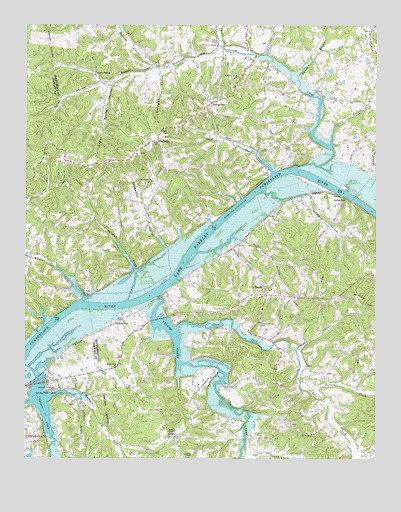
Needmore, TN USGS Topographic Map
Click on map above to begin viewing in our Map Viewer.

This topographic map contains these locations and features:
Feature Name Type Latitude Longitude GNIS ID View Map
Bartee BranchStreamN36.4842°W87.5275°1304975View Map
Bascomb Eldrige CreekStreamN36.4867°W87.5767°1304986View Map
Bear CreekStreamN36.4309°W87.5678°1311452View Map
Bellamy (historical)Populated PlaceN36.4878°W87.5781°1311453View Map
Blooming Grove ChurchChurchN36.4853°W87.5486°1305293View Map
Blooming Grove CreekStreamN36.4589°W87.5278°1305294View Map
Bowling Green HollowValleyN36.4155°W87.6185°1308793View Map
Burney CreekStreamN36.3942°W87.5231°1279076View Map
Cave SpringPopulated PlaceN36.4862°W87.5995°1314803View Map
Central School (historical)SchoolN36.3959°W87.5895°1319599View Map
Collier LandingLocaleN36.4573°W87.5378°1314870View Map
Commissioner District 7CivilN36.4957°W87.5241°2464633View Map
Cooper CreekStreamN36.4931°W87.5539°1281206View Map
CorbandalePopulated PlaceN36.4487°W87.5131°1314891View Map
Covington HollowValleyN36.4857°W87.5768°1281439View Map
District 19 (historical)CivilN36.4334°W87.5333°1325943View Map
District 9 (historical)CivilN36.4834°W87.5500°1325933View Map
Dog HollowValleyN36.4381°W87.5479°1282594View Map
Dry BranchStreamN36.4928°W87.5217°1282867View Map
Dunbars Landing (historical)LocaleN36.4128°W87.6189°1642936View Map
East Fork Yellow CreekStreamN36.4128°W87.5708°1283374View Map
Evergreen ChurchChurchN36.4553°W87.5797°1283931View Map
Evergreen School (historical)SchoolN36.4545°W87.5803°1319625View Map
Fessey HollowValleyN36.4513°W87.5251°1284227View Map
Flint RidgeRidgeN36.4253°W87.5195°1284488View Map
Guices CreekStreamN36.3992°W87.6195°1286375View Map
Guices Creek Recreation AreaParkN36.3945°W87.6167°1308860View Map
Gunson RidgeRidgeN36.3814°W87.6047°1647087View Map
Isaiah HollowValleyN36.4833°W87.5982°1289068View Map
Jackass HollowValleyN36.4371°W87.5502°1289164View Map
Jarman HollowValleyN36.4065°W87.5282°1289304View Map
Legs LandingLocaleN36.4528°W87.5120°1645011View Map
Lewis ChapelChurchN36.3767°W87.5678°1291077View Map
LinersPopulated PlaceN36.3823°W87.5711°1315406View Map
Liners Chapel School (historical)SchoolN36.3812°W87.5739°1319661View Map
Lock C (historical)DamN36.4228°W87.5770°1645002View Map
Major Lewis Landing (historical)LocaleN36.4223°W87.6042°1642947View Map
Marshall CreekStreamN36.4295°W87.5858°1292763View Map
McKendree ChurchChurchN36.3751°W87.6067°1293353View Map
Moccasin BranchStreamN36.3931°W87.6167°1294137View Map
Mount Ararat ChurchChurchN36.3823°W87.5225°1294550View Map
Mount Ararat School (historical)SchoolN36.3820°W87.5222°1319672View Map
NeedmorePopulated PlaceN36.4662°W87.5786°1295306View Map
New York (historical)Populated PlaceN36.4612°W87.5306°1645018View Map
Newman HollowValleyN36.4487°W87.6240°1308924View Map
Outlaw BranchStreamN36.4659°W87.5161°1296531View Map
Outlaw LandingLocaleN36.4501°W87.5481°1645020View Map
Owl HollowValleyN36.3767°W87.5431°1296608View Map
Palmyra Volunteer Fire Service Station 15BuildingN36.4205°W87.5189°2653790View Map
Poplar Spring Furnace (historical)LocaleN36.4714°W87.5978°1319695View Map
Poplar Spring HollowValleyN36.4826°W87.5950°1298229View Map
Reynolds Landing (historical)LocaleN36.4256°W87.5761°1645021View Map
Sailors RestLocaleN36.4159°W87.5900°1300410View Map
Sailors Rest ChurchChurchN36.4023°W87.5917°1300411View Map
Sailors Rest Church (historical)ChurchN36.3881°W87.5753°1319703View Map
Sailors Rest Landing (historical)LocaleN36.4181°W87.5917°1645023View Map
Schuff HollowValleyN36.3928°W87.6015°1308966View Map
Steele Furnace (historical)LocaleN36.3978°W87.5481°1319717View Map
StringtownPopulated PlaceN36.4778°W87.5592°1271603View Map
Sugar CreekStreamN36.4581°W87.5367°1271663View Map
TarsusPopulated PlaceN36.4237°W87.5392°1272137View Map
Tarsus ChurchChurchN36.4231°W87.5383°1319720View Map
Taylors Grove Church (historical)ChurchN36.4398°W87.6042°1319722View Map
Thomaston HollowValleyN36.4358°W87.5750°1272499View Map
Union School (historical)SchoolN36.4142°W87.5411°1319727View Map
Wildcat CreekStreamN36.4209°W87.6045°1274535View Map
Wilees ChapelChurchN36.4945°W87.5564°1304589View Map
Williams ChapelChurchN36.3831°W87.5736°1274690View Map
Wilson Chapel (historical)ChurchN36.3987°W87.5364°1319734View Map
Woodlawn-Dotsonville Division (historical)CensusN36.4928°W87.5081°1648886View Map
Yellow CreekStreamN36.4223°W87.5772°1275277View Map
Yellow Creek Forge (historical)LocaleN36.3981°W87.5486°1319738View Map
Yellow Creek Tow HeadBarN36.4326°W87.5672°1645033View Map
York LandingLocaleN36.4592°W87.5289°1314550View Map

Note: Coordinates in the location and feature list above are referenced to NAD83 datum.


Copyright (C) 2008-2024 Ryan Niemi / Sunset Dynamics ... All Rights Reserved