TopoQuest Logo
Do you find TopoQuest useful?
Help keep TopoQuest running and adding new maps/features by donating!
Bitcoin:  19c7KJd3qBynnjoSw5npx9KScwjBe4ifkT
Litecoin:  LXs6TkuXGGXo1vDsWCkWVdjQX94eUKd6ui
Home View Maps Find Maps Find Places Resources & Links


New Providence, Tennessee Topographic Map

USGS Map Title: New Providence, TN
USGS Map MRC: 36087E4
DRG (GeoTIFF) Download: o36087e4.tif


Neighboring USGS Topographic Map Quads:


  Herndon, KY  
36087F5
 

  Oak Grove, KY  
36087F4
 

  Trenton, KY  
36087F3
 

  Woodlawn, TN  
36087E5
 

  New Providence, TN  
36087E4
 

  Clarksville, TN  
36087E3
 

  Needmore, TN  
36087D5
 

  Palmyra, TN  
36087D4
 

  Excell, TN  
36087D3


Map MRC Location:

N37°
W88°
N37°
W87°
H8 H7 H6 H5 H4 H3 H2 H1
G8 G7 G6 G5 G4 G3 G2 G1
F8 F7 F6 F5 F4 F3 F2 F1
E8 E7 E6 E5 E4 E3 E2 E1
D8 D7 D6 D5 D4 D3 D2 D1
C8 C7 C6 C5 C4 C3 C2 C1
B8 B7 B6 B5 B4 B3 B2 B1
A8 A7 A6 A5 A4 A3 A2 A1
N36°
W88°
N36°
W87°

New Providence, TN USGS 1:24K Topographic Map Preview:
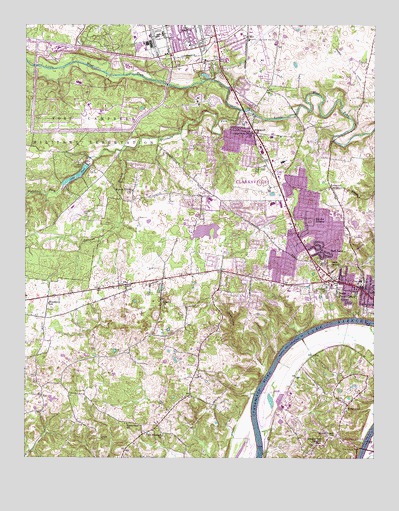
New Providence, TN USGS Topographic Map
Click on map above to begin viewing in our Map Viewer.

This topographic map contains these locations and features:
Feature Name Type Latitude Longitude GNIS ID View Map
Bel Air ParkParkN36.5709°W87.3900°1319584View Map
Bel-Air EstatesPopulated PlaceN36.5695°W87.4000°1276888View Map
Belle ForestPopulated PlaceN36.5737°W87.4414°1311457View Map
BellegladePopulated PlaceN36.6239°W87.4283°1311458View Map
BoxcroftPopulated PlaceN36.5737°W87.4250°1311465View Map
Boyd AcresPopulated PlaceN36.5514°W87.4281°1311466View Map
BrentwoodPopulated PlaceN36.5945°W87.3972°1311467View Map
BriarwoodPopulated PlaceN36.5156°W87.3845°1278320View Map
Briarwood ChurchChurchN36.5137°W87.3850°1319588View Map
Briarwood School (historical)SchoolN36.5137°W87.3861°1319589View Map
Byrns Darden Elementary SchoolSchoolN36.5512°W87.3800°1319593View Map
Camp TagaytayLocaleN36.5853°W87.4811°1279411View Map
Cave SpringSpringN36.5557°W87.3887°1279959View Map
CedargoldPopulated PlaceN36.5892°W87.3920°1311473View Map
Clarksville Base Physical Fitness CenterBuildingN36.6231°W87.4745°1319601View Map
Clarksville Fire Rescue Station 5BuildingN36.5515°W87.4004°2654130View Map
Clarksville Fire Rescue Station 6BuildingN36.5755°W87.4062°2654052View Map
Clarksville Police Department District 1BuildingN36.5882°W87.4129°2765785View Map
Cole Park Golf CourseLocaleN36.6139°W87.4403°1319612View Map
Commissioner District 11CivilN36.5657°W87.4255°2464342View Map
Commissioner District 12CivilN36.5895°W87.3866°2464360View Map
Commissioner District 16CivilN36.5527°W87.4030°2464396View Map
Commissioner District 9CivilN36.6169°W87.4082°2464737View Map
CountrybrookPopulated PlaceN36.5567°W87.4331°1311481View Map
Cumberland Heights Elementary SchoolSchoolN36.5045°W87.3956°1648294View Map
Cummingham BridgeBridgeN36.5028°W87.3786°1281846View Map
Cunningham BridgeBridgeN36.5028°W87.3786°1319616View Map
Dale TerracePopulated PlaceN36.5667°W87.3833°1311486View Map
Darnell EstatesPopulated PlaceN36.5562°W87.4011°1311487View Map
District 3 (historical)CivilN36.6000°W87.4417°1325927View Map
District 7 (historical)CivilN36.5500°W87.3833°1325931View Map
District 8 (historical)CivilN36.5167°W87.4667°1325932View Map
Donaldson CreekStreamN36.5231°W87.4147°1306378View Map
Fletchers ForkStreamN36.6003°W87.4233°1284476View Map
Fort Campbell Department of Defense Fire Department Station 1BuildingN36.6176°W87.4481°2637354View Map
Fort Campbell Department of Defense Fire Department Station 2BuildingN36.5715°W87.4840°2637355View Map
Fort Campbell Division (historical)CensusN36.6170°W87.4964°1648882View Map
FountainbleauPopulated PlaceN36.5534°W87.4045°1311495View Map
Gate Number OneLocaleN36.6156°W87.4308°1285231View Map
Gate Number TwoLocaleN36.6220°W87.4322°1285234View Map
Geiser BarBarN36.5017°W87.3792°1645007View Map
Hermitage EstatesPopulated PlaceN36.5856°W87.4197°1311504View Map
Johnson HeightsPopulated PlaceN36.5581°W87.3839°1311513View Map
KenwoodPopulated PlaceN36.5781°W87.3906°1290095View Map
Kenwood Baptist ChurchChurchN36.5753°W87.3892°1319655View Map
Kleenman Community CenterBuildingN36.5725°W87.4128°1319658View Map
Lake TaalReservoirN36.5815°W87.4821°1272020View Map
Lake Taal DamDamN36.5847°W87.4779°1307211View Map
Liberty ChurchChurchN36.5456°W87.4514°1291146View Map
Lintwood HeightsPopulated PlaceN36.5467°W87.4156°1311519View Map
Linwood LandingLocaleN36.5312°W87.4089°1645013View Map
Little West Fork ChurchChurchN36.5937°W87.4189°1291708View Map
Louise HeightsPopulated PlaceN36.5620°W87.4175°1311521View Map
MeadowbrookPopulated PlaceN36.5825°W87.4020°1311525View Map
Millswood EstatesPopulated PlaceN36.5903°W87.4111°1311527View Map
Montgomery County Vocational Technical SchoolSchoolN36.5723°W87.4345°1319677View Map
Montgomery EstatesPopulated PlaceN36.5670°W87.3753°1311529View Map
Morrison EstatesPopulated PlaceN36.5550°W87.4117°1311530View Map
Mount Pisgah ChurchChurchN36.5064°W87.3892°1294745View Map
Mount Pleasant ChurchChurchN36.5064°W87.4508°1294777View Map
New ProvidencePopulated PlaceN36.5487°W87.3792°1295623View Map
New Providence Middle SchoolSchoolN36.5734°W87.4117°1319681View Map
New Providence Post OfficePost OfficeN36.5681°W87.4053°1651270View Map
New Providence Recreation AreaParkN36.5412°W87.3828°1645017View Map
North HavenPopulated PlaceN36.5714°W87.4214°1311531View Map
North ParkPopulated PlaceN36.5895°W87.4061°1311532View Map
Northwest High SchoolSchoolN36.5745°W87.4339°1319683View Map
Northwood TerracePopulated PlaceN36.5737°W87.3900°1311534View Map
Oakland HeightsPopulated PlaceN36.5442°W87.4172°1311535View Map
Ogburn ChapelChurchN36.5100°W87.4645°1319686View Map
Outlaw FieldAirportN36.6232°W87.4186°1301439View Map
Park LanePopulated PlaceN36.5603°W87.3942°1296786View Map
Parr FieldAirportN36.5547°W87.4485°1301436View Map
Peachers MillPopulated PlaceN36.5709°W87.3845°1311539View Map
Raccoon BranchStreamN36.5887°W87.4658°1298789View Map
Ranch HillPopulated PlaceN36.5895°W87.3953°1311542View Map
RinggoldPopulated PlaceN36.5939°W87.4181°1299468View Map
Ringgold AcresPopulated PlaceN36.5917°W87.4270°1311544View Map
Ringgold Creek MillLocaleN36.5992°W87.4189°1326879View Map
Ringgold Elementary SchoolSchoolN36.5925°W87.4120°1319698View Map
Ringgold Mill Post OfficePost OfficeN36.5947°W87.4161°2766099View Map
Rosehill EstatesPopulated PlaceN36.5556°W87.4231°1311570View Map
Sabre Army Airfield (Fort Campbell)AirportN36.5722°W87.4828°2770301View Map
Sherwood ForestPopulated PlaceN36.6073°W87.4236°1311556View Map
SouthavenPopulated PlaceN36.5650°W87.4050°1311557View Map
Story Book AcresPopulated PlaceN36.6189°W87.4245°1311561View Map
Sunnyview ChurchChurchN36.5100°W87.4636°1271869View Map
Tradewinds North Shopping CenterLocaleN36.5714°W87.4067°1319724View Map
Trice LandingLocaleN36.5406°W87.3806°1645030View Map
Walnut Grove ChurchChurchN36.5773°W87.4620°1304358View Map
West Fork HillsPopulated PlaceN36.5892°W87.4203°1311568View Map
White HallBuildingN36.5987°W87.4183°1319731View Map
Wilmouth School (historical)SchoolN36.5303°W87.4920°1319733View Map
Woodlawn EstatesPopulated PlaceN36.5645°W87.4250°1311576View Map
Woodlawn SchoolSchoolN36.5448°W87.4914°1275059View Map

Note: Coordinates in the location and feature list above are referenced to NAD83 datum.


Copyright (C) 2008-2024 Ryan Niemi / Sunset Dynamics ... All Rights Reserved