TopoQuest Logo
Do you find TopoQuest useful?
Help keep TopoQuest running and adding new maps/features by donating!
Bitcoin:  19c7KJd3qBynnjoSw5npx9KScwjBe4ifkT
Litecoin:  LXs6TkuXGGXo1vDsWCkWVdjQX94eUKd6ui
Home View Maps Find Maps Find Places Resources & Links


Newark, Missouri Topographic Map

USGS Map Title: Newark, MO
USGS Map MRC: 39091H8
DRG (GeoTIFF) Download: o39091h8.tif


Neighboring USGS Topographic Map Quads:


  Edina SE, MO  
40092A1
 

  La Belle, MO  
40091A8
 

  Lewistown, MO  
40091A7
 

  Bethel, MO  
39092H1
 

  Newark, MO  
39091H8
 

  Nelsonville, MO  
39091H7
 

  Shelbyville, MO  
39092G1
 

  Burksville, MO  
39091G8
 

  Emden, MO  
39091G7


Map MRC Location:

N40°
W92°
N40°
W91°
H8 H7 H6 H5 H4 H3 H2 H1
G8 G7 G6 G5 G4 G3 G2 G1
F8 F7 F6 F5 F4 F3 F2 F1
E8 E7 E6 E5 E4 E3 E2 E1
D8 D7 D6 D5 D4 D3 D2 D1
C8 C7 C6 C5 C4 C3 C2 C1
B8 B7 B6 B5 B4 B3 B2 B1
A8 A7 A6 A5 A4 A3 A2 A1
N39°
W92°
N39°
W91°

Newark, MO USGS 1:24K Topographic Map Preview:
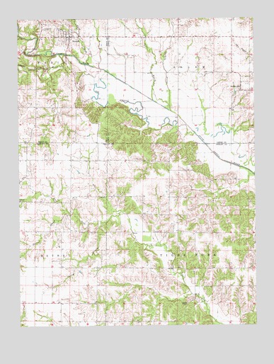
Newark, MO USGS Topographic Map
Click on map above to begin viewing in our Map Viewer.

This topographic map contains these locations and features:
Feature Name Type Latitude Longitude GNIS ID View Map
Bethel ChapelChurchN39.8839°W91.9118°714038View Map
Board BranchStreamN39.9087°W91.9391°733519View Map
Downing CemeteryCemeteryN39.9999°W91.9611°2777507View Map
ElginPopulated PlaceN39.9356°W91.9968°733514View Map
Elgin School (historical)SchoolN39.8867°W91.9318°733518View Map
Garrison Church (historical)ChurchN39.9262°W91.9930°733515View Map
Haman School (historical)SchoolN39.8848°W91.9838°733516View Map
Jones BranchStreamN39.9363°W91.8759°733520View Map
La Belle Fire Protection District SteffenvilleBuildingN39.9696°W91.8802°2621005View Map
Little Fabius RiverStreamN39.9856°W91.9782°721229View Map
Myers BranchStreamN39.9814°W91.9627°723096View Map
Nelson CemeteryCemeteryN39.9795°W91.9902°723165View Map
Nelson School (historical)SchoolN39.9639°W91.9857°733134View Map
NewarkPopulated PlaceN39.9931°W91.9730°723327View Map
Newark CemeteryCemeteryN39.9961°W91.9857°723328View Map
Newark Post OfficePost OfficeN39.9925°W91.9725°2782872View Map
Newark Rural Fire ProtectionBuildingN39.9925°W91.9725°2621547View Map
Old Channel South Fabius RiverStreamN39.9534°W91.9066°723735View Map
Old Newark Baptist Church CemeteryCemeteryN39.9955°W91.9763°2777517View Map
Seebers BranchStreamN39.9623°W91.9193°735844View Map
Shilo ChurchChurchN39.9262°W91.9996°726356View Map
Shiloh School (historical)SchoolN39.9256°W91.9977°733521View Map
Spees BranchStreamN39.9667°W91.9285°735862View Map
Spring BranchStreamN39.9170°W91.9568°726888View Map
Steffen LakeReservoirN39.9490°W91.9939°761843View Map
Steffen Lake DamDamN39.9500°W91.9885°761842View Map
SteffenvillePopulated PlaceN39.9706°W91.8821°735868View Map
Thomas BranchStreamN39.9214°W91.9741°727575View Map
Township of Tiger ForkCivilN39.8853°W91.9032°767415View Map
Village of NewarkCivilN39.9946°W91.9734°2399489View Map
Whitelock School (historical)SchoolN39.9281°W91.9210°733517View Map

Note: Coordinates in the location and feature list above are referenced to NAD83 datum.


Copyright (C) 2008-2024 Ryan Niemi / Sunset Dynamics ... All Rights Reserved