TopoQuest Logo
Do you find TopoQuest useful?
Help keep TopoQuest running and adding new maps/features by donating!
Bitcoin:  19c7KJd3qBynnjoSw5npx9KScwjBe4ifkT
Litecoin:  LXs6TkuXGGXo1vDsWCkWVdjQX94eUKd6ui
Home View Maps Find Maps Find Places Resources & Links


Nolanville, Texas Topographic Map

USGS Map Title: Nolanville, TX
USGS Map MRC: 31097A5
DRG (GeoTIFF) Download: o31097a5.tif


Neighboring USGS Topographic Map Quads:


  Post Oak Mountain, TX  
31097B6
 

  Bland, TX  
31097B5
 

  Moffat, TX  
31097B4
 

  Killeen, TX  
31097A6
 

  Nolanville, TX  
31097A5
 

  Belton, TX  
31097A4
 

  Youngsport, TX  
30097H6
 

  Salado, TX  
30097H5
 

  Holland, TX  
30097H4


Map MRC Location:

N32°
W98°
N32°
W97°
H8 H7 H6 H5 H4 H3 H2 H1
G8 G7 G6 G5 G4 G3 G2 G1
F8 F7 F6 F5 F4 F3 F2 F1
E8 E7 E6 E5 E4 E3 E2 E1
D8 D7 D6 D5 D4 D3 D2 D1
C8 C7 C6 C5 C4 C3 C2 C1
B8 B7 B6 B5 B4 B3 B2 B1
A8 A7 A6 A5 A4 A3 A2 A1
N31°
W98°
N31°
W97°

Nolanville, TX USGS 1:24K Topographic Map Preview:
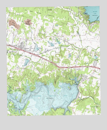
Nolanville, TX USGS Topographic Map
Click on map above to begin viewing in our Map Viewer.

This topographic map contains these locations and features:
Feature Name Type Latitude Longitude GNIS ID View Map
Bluff ParkParkN31.0016°W97.5450°2028753View Map
Burris CemeteryCemeteryN31.0266°W97.6172°1353381View Map
Camp Arrowhead Boy Scout CampLocaleN31.1235°W97.5606°1385302View Map
Camp TahuayaLocaleN31.0096°W97.5064°1353679View Map
CEN-TEX Humane SocietyBuildingN31.0877°W97.5556°1385303View Map
Chalk Ridge FallsFallsN31.0177°W97.5248°1385304View Map
Chalk Ridge Falls ParkParkN31.0210°W97.5250°1385305View Map
Chalk Ridge Falls Park TrailTrailN31.0171°W97.5281°2032868View Map
Christian FarmsLocaleN31.0474°W97.5814°1385306View Map
Church of ChristChurchN31.0780°W97.6058°1385307View Map
Church of Christ CampgroundLocaleN31.0766°W97.6147°1385308View Map
City of NolanvilleCivilN31.0754°W97.6111°2411261View Map
Comanche GapGapN31.0432°W97.6189°1384168View Map
Dana PeakSummitN31.0310°W97.6056°1355620View Map
Dana Peak ParkParkN31.0291°W97.6133°1385309View Map
Dana Peak Park TrailTrailN31.0310°W97.6072°2032828View Map
Dog Ridge (historical)Populated PlaceN31.0541°W97.5067°1356124View Map
End of Time Church of GodChurchN31.0621°W97.5053°1385310View Map
First Baptist ChurchChurchN31.0782°W97.6045°1385311View Map
First Baptist ChurchChurchN31.1021°W97.5164°1385312View Map
Harvest Center ChurchChurchN31.0763°W97.6078°1385313View Map
Highway of Holiness ChurchChurchN31.0813°W97.5995°1385314View Map
J W Sims Community CenterBuildingN31.0788°W97.5995°1385315View Map
Keys Valley ChurchChurchN31.0546°W97.5161°1385316View Map
KLFX-FM (Harker Heights)TowerN31.0899°W97.5989°1385872View Map
KYZZ-FM (Belton)TowerN31.0630°W97.5320°1385776View Map
Lake Boyd CallanLakeN31.0102°W97.5070°1352779View Map
McDowell CemeteryCemeteryN31.0849°W97.5445°1385317View Map
Nolan Valley ChurchChurchN31.0849°W97.5450°1363957View Map
NolanvillePopulated PlaceN31.0788°W97.6056°1363958View Map
Nolanville City HallBuildingN31.0778°W97.6055°2753195View Map
Nolanville Elementary SchoolSchoolN31.0741°W97.6211°1385318View Map
Nolanville Fire Department and Emergency Medical ServiceBuildingN31.0774°W97.6054°2552354View Map
Nolanville Police DepartmentBuildingN31.0777°W97.6056°2739202View Map
Nolanville Post OfficePost OfficeN31.0782°W97.6058°2732242View Map
Nolanville Student Achievement CenterSchoolN31.0791°W97.6097°1385319View Map
North Nolan CreekStreamN31.0766°W97.5245°1364103View Map
Overlook ParkParkN31.0321°W97.5300°1385320View Map
Proctor CemeteryCemeteryN31.0060°W97.5192°1385321View Map
Riversbend ParkParkN31.0035°W97.6067°1385322View Map
Shaw BranchStreamN31.0691°W97.5775°1368068View Map
Shaw Creek DamDamN31.1068°W97.5986°1863724View Map
Shaw Creek ReservoirReservoirN31.1067°W97.6005°1863725View Map
Soil Conservation Service Site 10 DamDamN31.0618°W97.5953°1858866View Map
Soil Conservation Service Site 10 ReservoirReservoirN31.0627°W97.5973°1858867View Map
Soil Conservation Service Site 11 DamDamN31.0735°W97.5803°1858864View Map
Soil Conservation Service Site 11 ReservoirReservoirN31.0746°W97.5807°1858865View Map
Soil Conservation Service Site 12 DamDamN31.0768°W97.5636°1858862View Map
Soil Conservation Service Site 12 ReservoirReservoirN31.0768°W97.5636°1858863View Map
Soil Conservation Service Site 13 DamDamN31.0818°W97.5553°1858860View Map
Soil Conservation Service Site 13 ReservoirReservoirN31.0838°W97.5550°1858861View Map
Soil Conservation Service Site 14 DamDamN31.0585°W97.5370°1858858View Map
Soil Conservation Service Site 14 ReservoirReservoirN31.0585°W97.5370°1858859View Map
Soil Conservation Service Site 15 DamDamN31.0685°W97.5053°1858856View Map
Soil Conservation Service Site 15 ReservoirReservoirN31.0663°W97.5057°1858857View Map
South Nolan CreekStreamN31.0768°W97.5245°1368727View Map
Stillhouse Baptist ChurchChurchN31.0460°W97.5125°1385323View Map
Stillhouse HollowValleyN31.0411°W97.5347°1369206View Map
Stillhouse Hollow DamDamN31.0335°W97.5336°1854270View Map
Stillhouse Hollow LakeReservoirN31.0189°W97.5868°1384052View Map
Stillhouse ParkParkN31.0388°W97.5414°1385324View Map
Stillhouse Volunteer Fire DepartmentBuildingN31.0421°W97.5183°2552268View Map
The NarrowsRidgeN31.0391°W97.5603°1369800View Map
Union GrovePopulated PlaceN31.0005°W97.6020°1380695View Map
Union Grove ParkParkN31.0085°W97.6214°1385325View Map
United Methodist ChurchChurchN31.0799°W97.6075°1385326View Map
WestcliffPopulated PlaceN31.1152°W97.5164°1384176View Map
Westcliff ParkParkN31.1218°W97.5195°1385327View Map
Yarrell Well Number TwoWellN31.0421°W97.5375°1372014View Map

Note: Coordinates in the location and feature list above are referenced to NAD83 datum.


Copyright (C) 2008-2024 Ryan Niemi / Sunset Dynamics ... All Rights Reserved