TopoQuest Logo
Do you find TopoQuest useful?
Help keep TopoQuest running and adding new maps/features by donating!
Bitcoin:  19c7KJd3qBynnjoSw5npx9KScwjBe4ifkT
Litecoin:  LXs6TkuXGGXo1vDsWCkWVdjQX94eUKd6ui
Home View Maps Find Maps Find Places Resources & Links


Salado, Texas Topographic Map

USGS Map Title: Salado, TX
USGS Map MRC: 30097H5
DRG (GeoTIFF) Download: o30097h5.tif


Neighboring USGS Topographic Map Quads:


  Killeen, TX  
31097A6
 

  Nolanville, TX  
31097A5
 

  Belton, TX  
31097A4
 

  Youngsport, TX  
30097H6
 

  Salado, TX  
30097H5
 

  Holland, TX  
30097H4
 

  Cobbs Cavern, TX  
30097G6
 

  Jarrell, TX  
30097G5
 

  Bartlett, TX  
30097G4


Map MRC Location:

N31°
W98°
N31°
W97°
H8 H7 H6 H5 H4 H3 H2 H1
G8 G7 G6 G5 G4 G3 G2 G1
F8 F7 F6 F5 F4 F3 F2 F1
E8 E7 E6 E5 E4 E3 E2 E1
D8 D7 D6 D5 D4 D3 D2 D1
C8 C7 C6 C5 C4 C3 C2 C1
B8 B7 B6 B5 B4 B3 B2 B1
A8 A7 A6 A5 A4 A3 A2 A1
N30°
W98°
N30°
W97°

Salado, TX USGS 1:24K Topographic Map Preview:
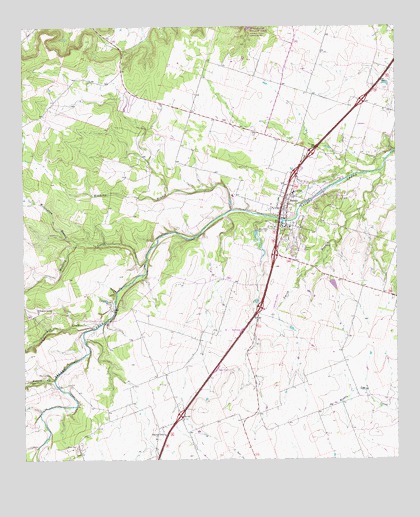
Salado, TX USGS Topographic Map
Click on map above to begin viewing in our Map Viewer.

This topographic map contains these locations and features:
Feature Name Type Latitude Longitude GNIS ID View Map
Anderson House and StoreBuildingN30.9463°W97.5370°2031569View Map
Armstrong-Adams HouseBuildingN30.9469°W97.5375°2031576View Map
Barbee-Berry Mercantile BuildingBuildingN30.9432°W97.5370°2031515View Map
Barton HouseBuildingN30.9477°W97.5356°2031525View Map
Bell County Constable's Office Precinct 2BuildingN30.9543°W97.5354°2739327View Map
Buttermilk CreekStreamN30.9144°W97.5992°1353430View Map
Captain Robert Halley HouseBuildingN30.9530°W97.5347°2031396View Map
Central Texas Area MuseumBuildingN30.9302°W97.5570°2014315View Map
Church of ChristChurchN30.9496°W97.5375°2041018View Map
Colonel Elijah Sterling Clack Robertson PlantationLocaleN30.9438°W97.5431°2032168View Map
Davis HouseBuildingN30.9449°W97.5367°2031333View Map
E S C Robertson Ranch LakeReservoirN30.9407°W97.5472°1862680View Map
E S C Robertson Ranch Lake DamDamN30.9419°W97.5470°1862679View Map
Emergency Medical StationHospitalN30.9513°W97.5370°2041015View Map
First Baptist ChurchChurchN30.9449°W97.5378°2041026View Map
Fowler HouseBuildingN30.9574°W97.5331°2031191View Map
George Washington Baines HouseBuildingN30.9421°W97.5328°2031134View Map
Grace Baptist ChurchChurchN30.9746°W97.5636°2040966View Map
Hendrickson-Caskey HouseBuildingN30.9452°W97.5314°2031104View Map
Levi Tenney HouseBuildingN30.9471°W97.5358°2030823View Map
Major A J Rose HouseBuildingN30.9405°W97.5295°2030775View Map
Mustang CreekStreamN30.9324°W97.5839°1363540View Map
Norton-Orgain HouseBuildingN30.9469°W97.5367°2031818View Map
Page ParkParkN30.9466°W97.5342°2029660View Map
Prairie DellPopulated PlaceN30.8841°W97.5803°1365725View Map
Prairie Dell Baptist ChurchChurchN30.8813°W97.5814°2041035View Map
Presbyterian Church of SaladoChurchN30.9555°W97.5333°2040992View Map
Rumsey CreekStreamN30.8980°W97.6153°1367001View Map
Saint Josephs Episcopal ChurchChurchN30.9557°W97.5339°2040990View Map
Saint Stephens Catholic ChurchChurchN30.9316°W97.5361°2041029View Map
SaladoPopulated PlaceN30.9471°W97.5386°1367336View Map
Salado AirportAirportN30.9190°W97.5421°1387448View Map
Salado CemeteryCemeteryN30.9363°W97.5317°1367337View Map
Salado City HallBuildingN30.9505°W97.5372°2041016View Map
Salado Civic CenterBuildingN30.9518°W97.5350°2041014View Map
Salado High SchoolSchoolN30.9493°W97.5442°2041025View Map
Salado Intermediate SchoolSchoolN30.9491°W97.5425°2041024View Map
Salado Post OfficePost OfficeN30.9543°W97.5350°2041013View Map
Salado Public LibraryBuildingN30.9571°W97.5328°2040970View Map
Salado SpringsSpringN30.9585°W97.5420°1998601View Map
Salado United Methodist ChurchChurchN30.9474°W97.5381°2032202View Map
Salado Volunteer Fire DepartmentBuildingN30.9488°W97.5377°2041019View Map
Salado Water TowerTowerN30.9577°W97.5322°2040968View Map
Salado Water TowerTowerN30.9410°W97.5300°2041028View Map
Smith BranchStreamN30.9585°W97.5050°1376153View Map
Solado Police DepartmentBuildingN30.9505°W97.5372°2041017View Map
South Bell DivisionCivilN30.9187°W97.5365°1939208View Map
Stagecoach InnBuildingN30.9421°W97.5378°2032577View Map
Tablerocks Goodnight AmphitheaterBuildingN30.9405°W97.5322°2041027View Map
Thomas Arnold Elementary SchoolSchoolN30.9488°W97.5422°2041022View Map
Twelve Oaks HouseBuildingN30.9460°W97.5322°2032532View Map
Tyler HouseBuildingN30.9455°W97.5375°2032533View Map
United Methodist Church of SaladoChurchN30.9471°W97.5381°2041020View Map
Vickrey HouseBuildingN30.9513°W97.5367°2032505View Map
Village of SaladoCivilN30.9484°W97.5266°2413586View Map
Watkins BranchStreamN30.9471°W97.5553°1370929View Map
White-Aiken HouseBuildingN30.9602°W97.5331°2032458View Map
Willingham BranchStreamN30.9377°W97.6072°1371600View Map
Willingham Springs Church (historical)ChurchN30.9180°W97.6206°1371601View Map
Wilmingham Springs Baptist ChurchChurchN30.9177°W97.6206°2041030View Map

Note: Coordinates in the location and feature list above are referenced to NAD83 datum.


Copyright (C) 2008-2024 Ryan Niemi / Sunset Dynamics ... All Rights Reserved