TopoQuest Logo
Do you find TopoQuest useful?
Help keep TopoQuest running and adding new maps/features by donating!
Bitcoin:  19c7KJd3qBynnjoSw5npx9KScwjBe4ifkT
Litecoin:  LXs6TkuXGGXo1vDsWCkWVdjQX94eUKd6ui
Home View Maps Find Maps Find Places Resources & Links


Oak Hill, Ohio Topographic Map

USGS Map Title: Oak Hill, OH
USGS Map MRC: 38082H5
DRG (GeoTIFF) Download: o38082h5.tif


Neighboring USGS Topographic Map Quads:


  Jackson, OH  
39082A6
 

  Wellston, OH  
39082A5
 

  Mulga, OH  
39082A4
 

  Petersburg, OH  
38082H6
 

  Oak Hill, OH  
38082H5
 

  Rio Grande, OH  
38082H4
 

  South Webster, OH  
38082G6
 

  Gallia, OH  
38082G5
 

  Patriot, OH  
38082G4


Map MRC Location:

N39°
W83°
N39°
W82°
H8 H7 H6 H5 H4 H3 H2 H1
G8 G7 G6 G5 G4 G3 G2 G1
F8 F7 F6 F5 F4 F3 F2 F1
E8 E7 E6 E5 E4 E3 E2 E1
D8 D7 D6 D5 D4 D3 D2 D1
C8 C7 C6 C5 C4 C3 C2 C1
B8 B7 B6 B5 B4 B3 B2 B1
A8 A7 A6 A5 A4 A3 A2 A1
N38°
W83°
N38°
W82°

Oak Hill, OH USGS 1:24K Topographic Map Preview:
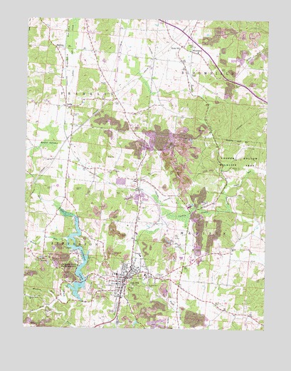
Oak Hill, OH USGS Topographic Map
Click on map above to begin viewing in our Map Viewer.

This topographic map contains these locations and features:
Feature Name Type Latitude Longitude GNIS ID View Map
Arthur CemeteryCemeteryN38.9295°W82.5752°1075279View Map
Baker SwampSwampN38.9493°W82.6136°1075297View Map
BannerPopulated PlaceN38.9401°W82.5949°1065522View Map
Banner Post Office (historical)Post OfficeN38.9404°W82.5943°2013707View Map
Bloomfield Elementary SchoolSchoolN38.9867°W82.5363°1049578View Map
Bloomfield Volunteer Fire DepartmentBuildingN38.9854°W82.5339°2549946View Map
Brady CemeteryCemeteryN38.9445°W82.5785°1075434View Map
Buckley CemeteryCemeteryN38.9736°W82.5840°1075476View Map
Cackley SwampSwampN38.9235°W82.5380°1075499View Map
Calahan CemeteryCemeteryN38.9379°W82.5797°1075504View Map
CambaPopulated PlaceN38.9648°W82.6052°1075510View Map
Camba Post Office (historical)Post OfficeN38.9654°W82.6054°2013713View Map
Central Elementary SchoolSchoolN38.8973°W82.5691°1049581View Map
ClayPopulated PlaceN38.9354°W82.5668°1075581View Map
Clay CemeteryCemeteryN38.9353°W82.5646°1964021View Map
Clay Post Office (historical)Post OfficeN38.9348°W82.5666°2013715View Map
Congregational CemeteryCemeteryN38.8931°W82.5602°1069160View Map
Cooper HollowValleyN38.9365°W82.5160°1075627View Map
Cub RunStreamN38.8829°W82.6099°1075658View Map
Faith United Methodist ChurchChurchN38.8954°W82.5763°1071604View Map
Franklin CemeteryCemeteryN38.9612°W82.6004°1075874View Map
Franklin Elementary SchoolSchoolN38.9640°W82.6029°1049583View Map
Fraser CemeteryCemeteryN38.9778°W82.5371°1075877View Map
Grassy ForkStreamN38.9395°W82.5202°1063443View Map
Hewitt RunStreamN38.9115°W82.6035°1076042View Map
Hickory Grove ChurchChurchN38.8870°W82.6221°1076043View Map
HitchcockPopulated PlaceN38.8834°W82.5757°1065693View Map
HorebPopulated PlaceN38.9034°W82.6121°1067414View Map
Horeb CemeteryCemeteryN38.9009°W82.6127°1964023View Map
Horeb ChurchChurchN38.9017°W82.6129°1076079View Map
Jackson LakeReservoirN38.8903°W82.5974°1076130View Map
Jackson Lake DamDamN38.8922°W82.6021°1078739View Map
Jackson Lake State ReserveParkN38.8990°W82.6013°1076131View Map
James A Rhodes AirportAirportN38.9856°W82.5760°1082751View Map
Jenkins CemeteryCemeteryN38.9318°W82.6142°1076138View Map
Johnson CemeteryCemeteryN38.9312°W82.5985°1076152View Map
KeystonePopulated PlaceN38.9881°W82.6091°1076178View Map
Liberty Baptist ChurchChurchN38.9023°W82.5624°1807471View Map
Limestone (historical)Populated PlaceN38.9548°W82.5290°1067415View Map
Mackley CemeteryCemeteryN38.8892°W82.5890°1076322View Map
Mackley RunStreamN38.8865°W82.6071°1076323View Map
Madison - Jefferson Volunteer Fire DepartmentBuildingN38.8973°W82.5704°2549947View Map
Madison CemeteryCemeteryN38.9404°W82.5145°1076326View Map
Marcum CemeteryCemeteryN38.9740°W82.5165°1076338View Map
McKitterick (historical)Populated PlaceN38.9092°W82.5413°1067417View Map
McKitterick CemeteryCemeteryN38.9076°W82.5429°1076367View Map
McNeal CemeteryCemeteryN38.9126°W82.5743°1076370View Map
Moriah CemeteryCemeteryN38.9081°W82.5165°1964025View Map
Moriah ChurchChurchN38.9079°W82.5171°1076433View Map
Oak HillPopulated PlaceN38.8940°W82.5735°1080995View Map
Oak Hill CemeteryCemeteryN38.8967°W82.5546°1076540View Map
Oak Hill High SchoolSchoolN38.8970°W82.5768°1049590View Map
Oak Hill Hospital HeliportAirportN38.8959°W82.5771°1082916View Map
Oak Hill Post Office (historical)Post OfficeN38.8945°W82.5735°2013761View Map
Oak Hill Presbyterian ChurchChurchN38.8965°W82.5699°1071621View Map
Oak Hill Upground Reservoir DamDamN38.9334°W82.5782°1079279View Map
Oak Hill Welsh Congregational ChurchChurchN38.8956°W82.5691°1069161View Map
Oak View Elementary SchoolSchoolN38.9045°W82.5646°1076546View Map
Price CemeteryCemeteryN38.9012°W82.5743°1076688View Map
PyroPopulated PlaceN38.9242°W82.5324°1076700View Map
Pyro Presbyterian ChurchChurchN38.9251°W82.5321°1071622View Map
RempelPopulated PlaceN38.9362°W82.5210°1065524View Map
Rocky HillPopulated PlaceN38.9890°W82.5449°1076760View Map
Rockyhill Post Office (historical)Post OfficeN38.9890°W82.5443°2013758View Map
Saint Paul United Methodist ChurchChurchN38.8976°W82.5682°1071625View Map
Sheppard CemeteryCemeteryN38.8815°W82.6110°1076882View Map
South SchoolSchoolN38.8898°W82.5771°1076937View Map
Southeast Ohio Emergency Medical Services Station 10 Oak HillBuildingN38.8965°W82.5700°2550877View Map
Sugar RunStreamN38.9334°W82.5204°1076993View Map
Township of FranklinCivilN38.9802°W82.6162°1086365View Map
Township of MadisonCivilN38.9002°W82.5089°1086371View Map
Trinity Wesleyan ChurchChurchN38.9001°W82.5718°1071629View Map
Village of Oak HillCivilN38.8962°W82.5691°2399537View Map
Webb CemeteryCemeteryN38.9667°W82.5777°1077150View Map
WinchesterPopulated PlaceN38.9870°W82.5390°1077206View Map
Winchester CemeteryCemeteryN38.9898°W82.5393°1068803View Map
Winchester Methodist ChurchChurchN38.9895°W82.5393°1068804View Map
Zoar CemeteryCemeteryN38.9484°W82.5496°1964032View Map
Zoar ChurchChurchN38.9490°W82.5485°1077260View Map

Note: Coordinates in the location and feature list above are referenced to NAD83 datum.


Copyright (C) 2008-2024 Ryan Niemi / Sunset Dynamics ... All Rights Reserved