TopoQuest Logo
Do you find TopoQuest useful?
Help keep TopoQuest running and adding new maps/features by donating!
Bitcoin:  19c7KJd3qBynnjoSw5npx9KScwjBe4ifkT
Litecoin:  LXs6TkuXGGXo1vDsWCkWVdjQX94eUKd6ui
Home View Maps Find Maps Find Places Resources & Links


Osgood, Ohio Topographic Map

USGS Map Title: Osgood, OH
USGS Map MRC: 40084C4
DRG (GeoTIFF) Download: o40084c4.tif


Neighboring USGS Topographic Map Quads:


  Montezuma, OH  
40084D5
 

  New Bremen, OH  
40084D4
 

  New Knoxville, OH  
40084D3
 

  North Star, OH  
40084C5
 

  Osgood, OH  
40084C4
 

  Fort Loramie, OH  
40084C3
 

  Dawn, OH  
40084B5
 

  Versailles, OH  
40084B4
 

  Piqua West, OH  
40084B3


Map MRC Location:

N41°
W85°
N41°
W84°
H8 H7 H6 H5 H4 H3 H2 H1
G8 G7 G6 G5 G4 G3 G2 G1
F8 F7 F6 F5 F4 F3 F2 F1
E8 E7 E6 E5 E4 E3 E2 E1
D8 D7 D6 D5 D4 D3 D2 D1
C8 C7 C6 C5 C4 C3 C2 C1
B8 B7 B6 B5 B4 B3 B2 B1
A8 A7 A6 A5 A4 A3 A2 A1
N40°
W85°
N40°
W84°

Osgood, OH USGS 1:24K Topographic Map Preview:
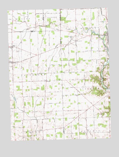
Osgood, OH USGS Topographic Map
Click on map above to begin viewing in our Map Viewer.

This topographic map contains these locations and features:
Feature Name Type Latitude Longitude GNIS ID View Map
Barhorst LakeReservoirN40.2988°W84.3784°1077863View Map
Barhorst Lake DamDamN40.2984°W84.3783°1077862View Map
Bruey School (historical)SchoolN40.2570°W84.4147°1053852View Map
English CemeteryCemeteryN40.2502°W84.4593°1040210View Map
Fort Loramie ParkParkN40.3503°W84.3777°1731063View Map
Frantz School (historical)SchoolN40.2556°W84.4844°1055511View Map
Grassy ForkStreamN40.2814°W84.4894°1041068View Map
Kramer FarmsLocaleN40.2594°W84.4636°2710815View Map
Lawrence RunStreamN40.2973°W84.3791°1063122View Map
Mendenhall CemeteryCemeteryN40.3209°W84.4977°1806173View Map
Mile CreekStreamN40.3445°W84.3808°1043304View Map
Nason School (historical)SchoolN40.2842°W84.4827°1055533View Map
OsgoodPopulated PlaceN40.3398°W84.4952°1044204View Map
Osgood Community Volunteer Fire DepartmentBuildingN40.3394°W84.4970°2550477View Map
Osgood Life SquadBuildingN40.3394°W84.4970°2550909View Map
Osgood Post OfficePost OfficeN40.3403°W84.4958°1967975View Map
Poppleman School (historical)SchoolN40.3398°W84.4533°1055538View Map
Ridge School (historical)SchoolN40.2848°W84.4547°1055541View Map
Saint Martins CemeteryCemeteryN40.3356°W84.4902°1045631View Map
Saint Nicholas Catholic ChurchChurchN40.3406°W84.4927°1069107View Map
Salt LickStreamN40.3045°W84.3852°1063124View Map
Schafer Dairy FarmsLocaleN40.2542°W84.3878°2710867View Map
School Number 6 (historical)SchoolN40.2556°W84.4483°1055544View Map
Spring CreekStreamN40.3503°W84.4108°1046549View Map
Steinman (historical)Populated PlaceN40.3675°W84.4936°1068235View Map
Straker School (historical)SchoolN40.3070°W84.4952°1055554View Map
Strakers (historical)Populated PlaceN40.3062°W84.4955°1067528View Map
Township of PattersonCivilN40.3096°W84.4785°1086021View Map
Tuente FarmsLocaleN40.2836°W84.4456°2710810View Map
Turner School (historical)SchoolN40.2845°W84.4155°1053944View Map
Village of OsgoodCivilN40.3394°W84.4956°2399590View Map
Village of YorkshireCivilN40.3253°W84.4950°2399753View Map
Walkup CemeteryCemeteryN40.3445°W84.4155°1047510View Map
Walkup Country ClubLocaleN40.3437°W84.4152°1080220View Map
Walkup School (historical)SchoolN40.3437°W84.4152°1053947View Map
WillowdellPopulated PlaceN40.3064°W84.4538°1061789View Map
Willowdell CemeteryCemeteryN40.3067°W84.4394°1047966View Map
Willowdell Post Office (historical)Post OfficeN40.3070°W84.4541°1968209View Map
Willowdell School (historical)SchoolN40.3134°W84.4536°1055568View Map
Yoder CemeteryCemeteryN40.2595°W84.4605°1048197View Map
YorkshirePopulated PlaceN40.3253°W84.4955°1058155View Map
Yorkshire Post Office (historical)Post OfficeN40.3250°W84.4958°1968214View Map

Note: Coordinates in the location and feature list above are referenced to NAD83 datum.


Copyright (C) 2008-2024 Ryan Niemi / Sunset Dynamics ... All Rights Reserved