TopoQuest Logo
Do you find TopoQuest useful?
Help keep TopoQuest running and adding new maps/features by donating!
Bitcoin:  19c7KJd3qBynnjoSw5npx9KScwjBe4ifkT
Litecoin:  LXs6TkuXGGXo1vDsWCkWVdjQX94eUKd6ui
Home View Maps Find Maps Find Places Resources & Links


Paddock Lake, Wisconsin Topographic Map

USGS Map Title: Paddock Lake, WI
USGS Map MRC: 42088E1
DRG (GeoTIFF) Download: o42088e1.tif


Neighboring USGS Topographic Map Quads:


  Rochester, WI  
42088F2
 

  Union Grove, WI  
42088F1
 

  Sturtevant, WI  
42087F8
 

  Silver Lake, WI  
42088E2
 

  Paddock Lake, WI  
42088E1
 

  Pleasant Prairie, WI  
42087E8
 

  Fox Lake, IL  
42088D2
 

  Antioch, IL  
42088D1
 

  Wadsworth, IL  
42087D8


Map MRC Location:

N43°
W89°
N43°
W88°
H8 H7 H6 H5 H4 H3 H2 H1
G8 G7 G6 G5 G4 G3 G2 G1
F8 F7 F6 F5 F4 F3 F2 F1
E8 E7 E6 E5 E4 E3 E2 E1
D8 D7 D6 D5 D4 D3 D2 D1
C8 C7 C6 C5 C4 C3 C2 C1
B8 B7 B6 B5 B4 B3 B2 B1
A8 A7 A6 A5 A4 A3 A2 A1
N42°
W89°
N42°
W88°

Paddock Lake, WI USGS 1:24K Topographic Map Preview:
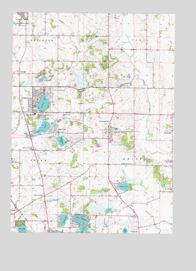
Paddock Lake, WI USGS Topographic Map
Click on map above to begin viewing in our Map Viewer.

This topographic map contains these locations and features:
Feature Name Type Latitude Longitude GNIS ID View Map
Barber PondLakeN42.5241°W88.0536°1561157View Map
Benet LakeLakeN42.5031°W88.0697°404169View Map
Binzel AirportAirportN42.5788°W88.0141°1582138View Map
Brighton CreekStreamN42.5897°W88.0276°1562208View Map
BristolPopulated PlaceN42.5589°W88.0492°1562217View Map
Bristol - Paris CemeteryCemeteryN42.5831°W88.0016°1998787View Map
Bristol AirportAirportN42.5370°W88.0037°2444198View Map
Bristol Fire DepartmentBuildingN42.5569°W88.0484°2697978View Map
Bristol Post OfficePost OfficeN42.5581°W88.0489°2712479View Map
Bristol SchoolSchoolN42.5567°W88.0525°1570403View Map
Bristol Wastewater Treatment PlantLocaleN42.5608°W88.0433°2358192View Map
Carefree EstatesPopulated PlaceN42.5194°W88.1158°2508193View Map
Central High SchoolSchoolN42.5673°W88.1070°1562897View Map
Christ Lutheran ChurchChurchN42.5675°W88.1119°2712561View Map
Dutch Gap AirstripAirportN42.5238°W88.0166°1581900View Map
Dutch Gap CanalCanalN42.5111°W88.0181°1564209View Map
Edquist FarmsLocaleN42.6136°W88.0281°2712469View Map
Elfering Dairy FarmLocaleN42.5078°W88.0089°2712474View Map
George LakeLakeN42.5266°W88.0382°1565464View Map
Holy Family ConventChurchN42.5111°W88.0784°1566602View Map
Hooker LakeLakeN42.5592°W88.1010°1566667View Map
Hosmer CemeteryCemeteryN42.5100°W88.0288°1566754View Map
KlondikePopulated PlaceN42.5900°W88.1195°1567552View Map
Lake Shangri La and Benet Lake 1ReservoirN42.5067°W88.0650°1791947View Map
Lake Shangri La DamDamN42.5067°W88.0651°1791946View Map
Lake ShangrilaPopulated PlaceN42.5053°W88.0706°1877175View Map
Lake ShangrilaLakeN42.5059°W88.0723°1573961View Map
Lake Shangrila Census Designated Place (historical)CensusN42.5030°W88.0703°2393084View Map
League LakeLakeN42.5867°W88.1025°1567916View Map
Liberty CemeteryCemeteryN42.5178°W88.0978°1568010View Map
Liberty CornersPopulated PlaceN42.5209°W88.0993°1568012View Map
Montgomery LakeLakeN42.5520°W88.0869°1569679View Map
Mud LakeLakeN42.5016°W88.0368°1569904View Map
Old Settlers ParkParkN42.5678°W88.0998°1570784View Map
Paasch LakeLakeN42.5129°W88.0499°1570981View Map
Paddock LakeLakeN42.5731°W88.1011°1570988View Map
Paddock LakePopulated PlaceN42.5775°W88.1051°1570989View Map
Paddock Lake SchoolSchoolN42.5681°W88.0854°1570990View Map
Paulin PondLakeN42.6185°W88.1247°2764464View Map
Pheasant Run LandfillLocaleN42.5972°W88.0378°2635468View Map
Pikeville SchoolSchoolN42.5011°W88.0265°1571401View Map
Rock LakeReservoirN42.5016°W88.1156°1792171View Map
Rock Lake DamDamN42.5034°W88.1201°1792170View Map
SalemPopulated PlaceN42.5547°W88.1109°1573609View Map
Salem BranchStreamN42.5728°W88.0637°1573611View Map
Salem Fire and Rescue Station 1BuildingN42.5142°W88.1178°2698217View Map
Salem Fire and Rescue Station 2BuildingN42.5545°W88.1099°2697893View Map
Salem LakesPopulated PlaceN42.5318°W88.1016°2787906View Map
Salem OaksPopulated PlaceN42.5586°W88.0923°1573629View Map
Salem Post OfficePost OfficeN42.5548°W88.1096°2712480View Map
Salem SchoolSchoolN42.5480°W88.1094°1573610View Map
Salem United Methodist ChurchChurchN42.5542°W88.1133°2712562View Map
South Bristol SchoolSchoolN42.5395°W88.0401°1574423View Map
Town of Bristol (historical)CivilN42.5307°W88.0149°1582863View Map
TrevorPopulated PlaceN42.5125°W88.1209°1575601View Map
Trevor Post OfficePost OfficeN42.5114°W88.1209°2712481View Map
Union CemeteryCemeteryN42.5686°W88.0796°1575859View Map
Union League Boys CampLocaleN42.5889°W88.0979°1575906View Map
Village of BristolCivilN42.5378°W88.0150°2646685View Map
Village of Paddock LakeCivilN42.5706°W88.1046°1583889View Map
Voltz LakeLakeN42.5074°W88.0841°1576125View Map
Westosha AcademySchoolN42.5690°W88.1097°2716590View Map
Winfield AirportAirportN42.5181°W88.0273°1581898View Map
WoodworthPopulated PlaceN42.5581°W88.0012°1577043View Map
Woodworth Post OfficePost OfficeN42.5584°W88.0009°2712478View Map

Note: Coordinates in the location and feature list above are referenced to NAD83 datum.


Copyright (C) 2008-2024 Ryan Niemi / Sunset Dynamics ... All Rights Reserved