TopoQuest Logo
Do you find TopoQuest useful?
Help keep TopoQuest running and adding new maps/features by donating!
Bitcoin:  19c7KJd3qBynnjoSw5npx9KScwjBe4ifkT
Litecoin:  LXs6TkuXGGXo1vDsWCkWVdjQX94eUKd6ui
Home View Maps Find Maps Find Places Resources & Links


Silver Lake, Wisconsin Topographic Map

USGS Map Title: Silver Lake, WI
USGS Map MRC: 42088E2
DRG (GeoTIFF) Download: o42088e2.tif


Neighboring USGS Topographic Map Quads:


  Burlington, WI  
42088F3
 

  Rochester, WI  
42088F2
 

  Union Grove, WI  
42088F1
 

  Genoa City, WI  
42088E3
 

  Silver Lake, WI  
42088E2
 

  Paddock Lake, WI  
42088E1
 

  Richmond, IL  
42088D3
 

  Fox Lake, IL  
42088D2
 

  Antioch, IL  
42088D1


Map MRC Location:

N43°
W89°
N43°
W88°
H8 H7 H6 H5 H4 H3 H2 H1
G8 G7 G6 G5 G4 G3 G2 G1
F8 F7 F6 F5 F4 F3 F2 F1
E8 E7 E6 E5 E4 E3 E2 E1
D8 D7 D6 D5 D4 D3 D2 D1
C8 C7 C6 C5 C4 C3 C2 C1
B8 B7 B6 B5 B4 B3 B2 B1
A8 A7 A6 A5 A4 A3 A2 A1
N42°
W89°
N42°
W88°

Silver Lake, WI USGS 1:24K Topographic Map Preview:
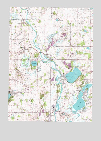
Silver Lake, WI USGS Topographic Map
Click on map above to begin viewing in our Map Viewer.

This topographic map contains these locations and features:
Feature Name Type Latitude Longitude GNIS ID View Map
Anchor Baptist ChurchChurchN42.5314°W88.2454°1850035View Map
Bass PondLakeN42.6236°W88.1306°2764457View Map
BassettPopulated PlaceN42.5406°W88.2279°1561291View Map
Bassett CreekStreamN42.5670°W88.2009°1561292View Map
Bassett Post OfficePost OfficeN42.5399°W88.2261°2712487View Map
Bright Horizons SchoolSchoolN42.5203°W88.1800°2716515View Map
Bullfrog PondLakeN42.6240°W88.1292°2764458View Map
Calvary Congregational ChurchChurchN42.5200°W88.2465°1850052View Map
Camp LakeLakeN42.5206°W88.1443°1562620View Map
Camp LakePopulated PlaceN42.5347°W88.1437°1562628View Map
Camp Lake AirportAirportN42.5297°W88.1561°1581910View Map
Camp Lake Census Designated Place (historical)CensusN42.5279°W88.1437°2393362View Map
Camp Lake Post OfficePost OfficeN42.5358°W88.1440°2712483View Map
Cedar Lawn FarmLocaleN42.5481°W88.2431°1850053View Map
Center LakeReservoirN42.5380°W88.1334°1562886View Map
Cull LakeLakeN42.5808°W88.1325°2764460View Map
Digger Dougs AirportAirportN42.5976°W88.1457°2444199View Map
Flanagan LakeLakeN42.6113°W88.1793°1565054View Map
Fox RiverPopulated PlaceN42.5570°W88.1845°1565230View Map
Fox River ParkParkN42.5375°W88.1737°1565233View Map
Foxewood Airport (historical)AirportN42.5709°W88.2001°1582111View Map
Holy Name CemeteryCemeteryN42.5101°W88.1734°1998790View Map
Holy Name ChurchChurchN42.5120°W88.1743°1850091View Map
Holy Name Elementary SchoolSchoolN42.5117°W88.1748°1850092View Map
Lakewood Elementary SchoolSchoolN42.5227°W88.2454°1850117View Map
Lilly LakeLakeN42.5632°W88.2125°1568037View Map
Lily Lake Census Designated PlaceCensusN42.5613°W88.2137°2586526View Map
Mud Turtle PondLakeN42.6244°W88.1265°2764463View Map
New MunsterPopulated PlaceN42.5795°W88.2279°1570228View Map
New Munster Bog Island State Natural AreaParkN42.5670°W88.2279°1988569View Map
New Munster CreekStreamN42.5875°W88.2145°1570229View Map
Palmer CreekStreamN42.5784°W88.2048°1570998View Map
Peace Evangelical Lutheran ChurchChurchN42.5122°W88.1798°1850138View Map
Peterson CreekStreamN42.5836°W88.2115°1571269View Map
Randall Fire Department Station 2BuildingN42.5354°W88.2159°2697866View Map
Riverview SchoolSchoolN42.5529°W88.1690°1850145View Map
Saint Alphonsus Catholic CemeteryCemeteryN42.5806°W88.2255°1998793View Map
Saint Alphonsus SchoolSchoolN42.5809°W88.2268°2716854View Map
Saint Johns Catholic CemeteryCemeteryN42.5308°W88.2156°1573026View Map
Saint Johns Catholic ChurchChurchN42.5386°W88.2481°1850159View Map
Salem Fire and Rescue Station 3BuildingN42.5118°W88.1758°2698020View Map
Salem Mound CemeteryCemeteryN42.5674°W88.1573°1573628View Map
Silver LakeLakeN42.5508°W88.1538°1574128View Map
Silver LakePopulated PlaceN42.5461°W88.1656°1574150View Map
Silver Lake Bog State Natural AreaParkN42.5517°W88.1340°1988787View Map
Silver Lake Police DepartmentBuildingN42.5491°W88.1674°2759694View Map
Silver Lake Post OfficePost OfficeN42.5433°W88.1675°2712559View Map
Silver Lake Rescue SquadBuildingN42.5494°W88.1691°2698289View Map
Silver Lake Volunteer Fire DepartmentBuildingN42.5491°W88.1677°2697965View Map
Town of RandallCivilN42.5342°W88.2171°1583994View Map
Town of Salem (historical)CivilN42.5358°W88.1297°1584093View Map
Town of WheatlandCivilN42.5820°W88.2469°1584421View Map
Trevor-Wilmot SchoolSchoolN42.5097°W88.1279°1575603View Map
Twin LakesPopulated PlaceN42.5311°W88.2481°1575813View Map
Village of Salem LakesCivilN42.5392°W88.1272°2787905View Map
Village of Silver Lake (historical)CivilN42.5492°W88.1669°1584162View Map
Village of Twin LakesCivilN42.5192°W88.2489°1584304View Map
Westosha AirportAirportN42.5125°W88.2054°1582273View Map
Westosha Emergency Center HeliportAirportN42.5425°W88.1704°1582208View Map
WheatlandPopulated PlaceN42.5939°W88.2084°1576599View Map
Wheatland EstatesPopulated PlaceN42.5986°W88.2006°2508611View Map
Wheatland Presbyterian CemeteryCemeteryN42.5768°W88.2329°1998788View Map
Wheatland Town ConstableBuildingN42.5796°W88.2272°2759880View Map
Wheatland Volunteer Fire DepartmentBuildingN42.5798°W88.2233°2697948View Map
WilmotPopulated PlaceN42.5128°W88.1820°1576805View Map
Wilmot CemeteryCemeteryN42.5118°W88.1885°1998797View Map
Wilmot Census Designated Place (historical)CensusN42.5085°W88.1866°2586573View Map
Wilmot Elementary SchoolSchoolN42.5203°W88.1800°1850202View Map
Wilmot Post OfficePost OfficeN42.5130°W88.1827°2712560View Map
Wilmot Union High SchoolSchoolN42.5152°W88.1829°1850203View Map
Wilmot United Methodist ChurchChurchN42.5106°W88.1829°1850204View Map

Note: Coordinates in the location and feature list above are referenced to NAD83 datum.


Copyright (C) 2008-2024 Ryan Niemi / Sunset Dynamics ... All Rights Reserved