TopoQuest Logo
Do you find TopoQuest useful?
Help keep TopoQuest running and adding new maps/features by donating!
Bitcoin:  19c7KJd3qBynnjoSw5npx9KScwjBe4ifkT
Litecoin:  LXs6TkuXGGXo1vDsWCkWVdjQX94eUKd6ui
Home View Maps Find Maps Find Places Resources & Links


Pinnacle Lake, Missouri Topographic Map

USGS Map Title: Pinnacle Lake, MO
USGS Map MRC: 38091G4
DRG (GeoTIFF) Download: o38091g4.tif


Neighboring USGS Topographic Map Quads:


  Montgomery City, MO  
38091H5
 

  New Florence, MO  
38091H4
 

  Bellflower South, MO  
38091H3
 

  Americus, MO  
38091G5
 

  Pinnacle Lake, MO  
38091G4
 

  Jonesburg, MO  
38091G3
 

  Gasconade, MO  
38091F5
 

  Hermann, MO  
38091F4
 

  Berger, MO  
38091F3


Map MRC Location:

N39°
W92°
N39°
W91°
H8 H7 H6 H5 H4 H3 H2 H1
G8 G7 G6 G5 G4 G3 G2 G1
F8 F7 F6 F5 F4 F3 F2 F1
E8 E7 E6 E5 E4 E3 E2 E1
D8 D7 D6 D5 D4 D3 D2 D1
C8 C7 C6 C5 C4 C3 C2 C1
B8 B7 B6 B5 B4 B3 B2 B1
A8 A7 A6 A5 A4 A3 A2 A1
N38°
W92°
N38°
W91°

Pinnacle Lake, MO USGS 1:24K Topographic Map Preview:
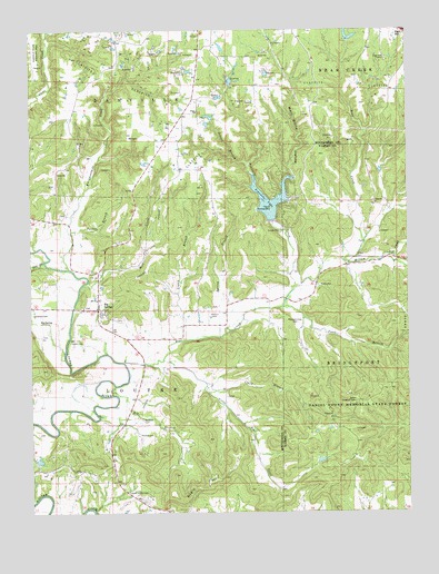
Pinnacle Lake, MO USGS Topographic Map
Click on map above to begin viewing in our Map Viewer.

This topographic map contains these locations and features:
Feature Name Type Latitude Longitude GNIS ID View Map
Abattis (historical)Populated PlaceN38.8170°W91.3918°740069View Map
Abattis Post Office (historical)Post OfficeN38.8167°W91.3917°2091669View Map
Bear CreekStreamN38.7889°W91.4696°729426View Map
Bedford CemeteryCemeteryN38.7742°W91.4635°713849View Map
Big BranchStreamN38.7806°W91.4732°714136View Map
Big SpringPopulated PlaceN38.8025°W91.4777°714213View Map
Big SpringSpringN38.7992°W91.4967°714221View Map
Big Spring Census Designated PlaceCensusN38.8020°W91.4838°2587054View Map
Big Spring Fire Protection District Station 1BuildingN38.8034°W91.4773°2620908View Map
Boone Lookout TowerTowerN38.7800°W91.3940°755005View Map
Borgers Lake DamDamN38.8717°W91.4368°762201View Map
Calhoun HollowValleyN38.8748°W91.4929°715197View Map
Caroll CemeteryCemeteryN38.7942°W91.4871°715413View Map
Charles W Seng LakeReservoirN38.8397°W91.3835°764676View Map
Clark BranchStreamN38.7809°W91.4416°715871View Map
Daniel Boone Memorial State ForestForestN38.7750°W91.3904°716657View Map
Dry ForkStreamN38.8148°W91.4957°717108View Map
Ebenezer School (historical)SchoolN38.7732°W91.4604°744463View Map
Gryder Lake DamDamN38.8717°W91.3952°761563View Map
Haerer Lake DamDamN38.8634°W91.4185°762196View Map
High Hill CampLocaleN38.8667°W91.3815°719523View Map
Hugo ChurchChurchN38.8537°W91.4446°729519View Map
Hugo School (historical)SchoolN38.8534°W91.4440°744460View Map
Johnson Lake DamDamN38.8634°W91.4485°762200View Map
Jones BranchStreamN38.8034°W91.4168°720402View Map
Liberty School (historical)SchoolN38.8109°W91.4774°744461View Map
Little Bear CreekStreamN38.7892°W91.4566°721151View Map
Logan BranchStreamN38.7948°W91.4491°721413View Map
Logan School (historical)SchoolN38.8062°W91.4449°744462View Map
Loutre Island CemeteryCemeteryN38.7548°W91.4688°721616View Map
Mary White HollowValleyN38.8303°W91.4188°721946View Map
McKittrick School (historical)SchoolN38.7582°W91.4419°2651394View Map
Mill CreekStreamN38.8075°W91.4838°722325View Map
Millam CreekStreamN38.8153°W91.3960°722362View Map
Mononame 312 DamDamN38.7634°W91.4068°764328View Map
Negro HillSummitN38.7581°W91.4399°723156View Map
Noble Lake Dam - NorthDamN38.8517°W91.4402°762199View Map
Noble Lake South DamDamN38.8517°W91.4418°762198View Map
Painter Lake DamDamN38.8567°W91.4235°762197View Map
Patton CemeteryCemeteryN38.7700°W91.4643°724097View Map
Pinnacle CreekStreamN38.8081°W91.4124°724415View Map
Pinnacle LakeReservoirN38.8284°W91.4200°758327View Map
Pinnacle Lake DamDamN38.8267°W91.4202°764752View Map
Pleasant View CemeteryCemeteryN38.7986°W91.4129°724639View Map
School BranchStreamN38.8400°W91.4274°726114View Map
Seng Lake DamDamN38.8384°W91.3835°764675View Map
Snethen CemeteryCemeteryN38.8014°W91.4993°726659View Map
Spring BranchStreamN38.7956°W91.4377°726886View Map
The PinnacleIslandN38.8289°W91.4207°727566View Map
Thorney Hill DamDamN38.7634°W91.4985°764757View Map
Thorny Hill LakeReservoirN38.7636°W91.4977°764758View Map
Turkey BranchStreamN38.8228°W91.4874°727839View Map
Uthlaut CemeteryCemeteryN38.8018°W91.4394°728090View Map
Walnut Grove School (historical)SchoolN38.8162°W91.3910°747906View Map
Whippoorwill CreekStreamN38.8131°W91.4874°728702View Map

Note: Coordinates in the location and feature list above are referenced to NAD83 datum.


Copyright (C) 2008-2024 Ryan Niemi / Sunset Dynamics ... All Rights Reserved