TopoQuest Logo
Do you find TopoQuest useful?
Help keep TopoQuest running and adding new maps/features by donating!
Bitcoin:  19c7KJd3qBynnjoSw5npx9KScwjBe4ifkT
Litecoin:  LXs6TkuXGGXo1vDsWCkWVdjQX94eUKd6ui
Home View Maps Find Maps Find Places Resources & Links


Jonesburg, Missouri Topographic Map

USGS Map Title: Jonesburg, MO
USGS Map MRC: 38091G3
DRG (GeoTIFF) Download: o38091g3.tif


Neighboring USGS Topographic Map Quads:


  New Florence, MO  
38091H4
 

  Bellflower South, MO  
38091H3
 

  Hawk Point, MO  
38091H2
 

  Pinnacle Lake, MO  
38091G4
 

  Jonesburg, MO  
38091G3
 

  Warrenton, MO  
38091G2
 

  Hermann, MO  
38091F4
 

  Berger, MO  
38091F3
 

  Treloar, MO  
38091F2


Map MRC Location:

N39°
W92°
N39°
W91°
H8 H7 H6 H5 H4 H3 H2 H1
G8 G7 G6 G5 G4 G3 G2 G1
F8 F7 F6 F5 F4 F3 F2 F1
E8 E7 E6 E5 E4 E3 E2 E1
D8 D7 D6 D5 D4 D3 D2 D1
C8 C7 C6 C5 C4 C3 C2 C1
B8 B7 B6 B5 B4 B3 B2 B1
A8 A7 A6 A5 A4 A3 A2 A1
N38°
W92°
N38°
W91°

Jonesburg, MO USGS 1:24K Topographic Map Preview:
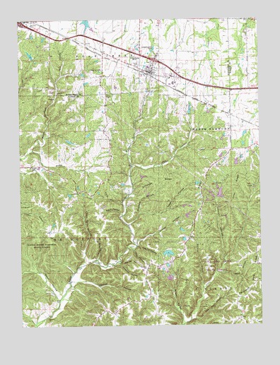
Jonesburg, MO USGS Topographic Map
Click on map above to begin viewing in our Map Viewer.

This topographic map contains these locations and features:
Feature Name Type Latitude Longitude GNIS ID View Map
Abe HollowValleyN38.7812°W91.3165°713122View Map
Adventures Aloft AirportAirportN38.8725°W91.3002°758740View Map
Baker HollowValleyN38.7959°W91.3227°713574View Map
Ball School (historical)SchoolN38.8464°W91.2740°744464View Map
Big Four School (historical)SchoolN38.8025°W91.3454°747908View Map
Bullar Lake DamDamN38.8267°W91.3518°761819View Map
Camp Sandy CreekStreamN38.7742°W91.3454°730323View Map
Camp Sandy HollowValleyN38.7770°W91.3413°715284View Map
Casper Lake DamDamN38.8534°W91.3418°761818View Map
Central School (historical)SchoolN38.7653°W91.3529°747909View Map
City of JonesburgCivilN38.8546°W91.3028°2395481View Map
Coleman CemeteryCemeteryN38.7737°W91.3096°716108View Map
Coleman HollowValleyN38.7753°W91.3243°716112View Map
Cool Valley LakeReservoirN38.8730°W91.3397°761580View Map
Crancers LakeReservoirN38.7795°W91.2983°761410View Map
Crancers Lake DamDamN38.7784°W91.3002°761409View Map
Crancers Lake Section 7 South DamDamN38.7684°W91.2968°762068View Map
Dead HollowValleyN38.7714°W91.2704°716765View Map
Donahue RidgeRidgeN38.8081°W91.3029°716971View Map
Giesel HollowValleyN38.7839°W91.3146°718434View Map
Greyham HollowValleyN38.7917°W91.3179°718867View Map
Hall HollowValleyN38.8156°W91.3163°719007View Map
Hambauch Lake DamDamN38.8150°W91.2635°761821View Map
Henley HollowValleyN38.7770°W91.2699°731580View Map
Hicks Lake Section 20 North DamDamN38.8250°W91.2702°761822View Map
Hicks Lake Section 20 South DamDamN38.8184°W91.2702°762098View Map
Hog Pen HollowValleyN38.7825°W91.3140°719681View Map
Jack HollowValleyN38.8523°W91.3532°720193View Map
John Scofield LakeReservoirN38.8371°W91.2865°761506View Map
JonesburgPopulated PlaceN38.8534°W91.3060°729525View Map
Jonesburg - High Hill Fire Protection DistrictBuildingN38.8545°W91.3085°2621237View Map
Jonesburg Elementary SchoolSchoolN38.8510°W91.2967°2651393View Map
Jonesburg Post OfficePost OfficeN38.8532°W91.3046°2782970View Map
Jordan HollowValleyN38.7687°W91.3452°720439View Map
Kelly HollowValleyN38.8000°W91.3218°720519View Map
Kelly Lake DamDamN38.8584°W91.3685°764020View Map
Kirby RidgeRidgeN38.8062°W91.2643°720642View Map
Lepp HollowValleyN38.7964°W91.3129°720918View Map
Little Camp Sandy HollowValleyN38.7773°W91.3349°721183View Map
Little Lost Creek State ForestForestN38.7764°W91.2718°742891View Map
Longstreet Lake DamDamN38.8084°W91.3202°764677View Map
Low Gap HollowValleyN38.7531°W91.2849°721635View Map
Martin School (historical)SchoolN38.7537°W91.2604°747911View Map
Muddy CreekStreamN38.8217°W91.3682°723031View Map
Oak Grove ChurchChurchN38.8045°W91.3454°723585View Map
Oak Grove School (historical)SchoolN38.8306°W91.3313°747907View Map
Pea RidgeRidgeN38.7973°W91.2815°724122View Map
Progressive School (historical)SchoolN38.7703°W91.3102°747910View Map
Ray CemeteryCemeteryN38.7617°W91.3038°725127View Map
Razor HollowValleyN38.7620°W91.3554°725140View Map
Robertson LakeReservoirN38.8608°W91.3692°764021View Map
Scachse CemeteryCemeteryN38.8143°W91.2735°726083View Map
Scofield Lake Number 3 DamDamN38.8367°W91.2868°761505View Map
Tightsqueeze FieldAirportN38.8703°W91.2602°758739View Map
Township of BridgeportCivilN38.7741°W91.3599°767498View Map
Twin Echoes LakeReservoirN38.8077°W91.3218°764678View Map
Watkins BranchStreamN38.7650°W91.2807°728413View Map
Wilson HollowValleyN38.7528°W91.2910°728976View Map
Wolf Den HollowValleyN38.7750°W91.3215°729055View Map
Wright CemeteryCemeteryN38.8146°W91.3684°729158View Map

Note: Coordinates in the location and feature list above are referenced to NAD83 datum.


Copyright (C) 2008-2024 Ryan Niemi / Sunset Dynamics ... All Rights Reserved