TopoQuest Logo
Do you find TopoQuest useful?
Help keep TopoQuest running and adding new maps/features by donating!
Bitcoin:  19c7KJd3qBynnjoSw5npx9KScwjBe4ifkT
Litecoin:  LXs6TkuXGGXo1vDsWCkWVdjQX94eUKd6ui
Home View Maps Find Maps Find Places Resources & Links


Platte City, Missouri Topographic Map

USGS Map Title: Platte City, MO
USGS Map MRC: 39094C7
DRG (GeoTIFF) Download: o39094c7.tif


Neighboring USGS Topographic Map Quads:


  Weston, MO  
39094D8
 

  Tracy, MO  
39094D7
 

  Camden Point, MO  
39094D6
 

  Leavenworth, KS  
39094C8
 

  Platte City, MO  
39094C7
 

  Ferrelview, MO  
39094C6
 

  Basehor, KS  
39094B8
 

  Wolcott, KS  
39094B7
 

  Parkville, MO  
39094B6


Map MRC Location:

N40°
W95°
N40°
W94°
H8 H7 H6 H5 H4 H3 H2 H1
G8 G7 G6 G5 G4 G3 G2 G1
F8 F7 F6 F5 F4 F3 F2 F1
E8 E7 E6 E5 E4 E3 E2 E1
D8 D7 D6 D5 D4 D3 D2 D1
C8 C7 C6 C5 C4 C3 C2 C1
B8 B7 B6 B5 B4 B3 B2 B1
A8 A7 A6 A5 A4 A3 A2 A1
N39°
W95°
N39°
W94°

Platte City, MO USGS 1:24K Topographic Map Preview:
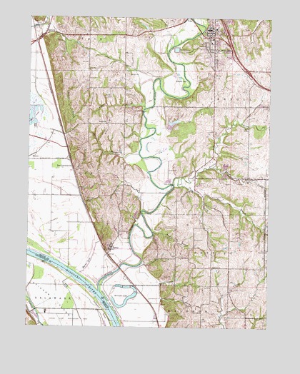
Platte City, MO USGS Topographic Map
Click on map above to begin viewing in our Map Viewer.

This topographic map contains these locations and features:
Feature Name Type Latitude Longitude GNIS ID View Map
Bain CemeteryCemeteryN39.3394°W94.7511°713551View Map
BeverlyPopulated PlaceN39.3681°W94.8672°740676View Map
Beverly LakeLakeN39.3642°W94.8504°739629View Map
Big CreekStreamN39.3097°W94.7575°739518View Map
Brown CemeteryCemeteryN39.3517°W94.8227°714768View Map
Burns LakeSwampN39.2754°W94.8441°715085View Map
BuxtonPopulated PlaceN39.3189°W94.8733°740717View Map
Central Platte Fire Protection DistrictBuildingN39.3701°W94.7820°2621740View Map
City of Platte CityCivilN39.3584°W94.7676°2396226View Map
Delaware BendBendN39.2528°W94.8308°478434View Map
Detner BridgeBridgeN39.3075°W94.8005°755047View Map
Dry Lake (historical)LakeN39.2506°W94.8097°734165View Map
East LeavenworthPopulated PlaceN39.3144°W94.8519°740823View Map
Eldorado SchoolSchoolN39.3322°W94.8352°717437View Map
Elm Grove ChurchChurchN39.2811°W94.7505°717515View Map
Elton FieldAirportN39.3369°W94.8098°758863View Map
FarleyPopulated PlaceN39.2822°W94.8314°717848View Map
Farley Post OfficePost OfficeN39.2815°W94.8315°2783089View Map
Fouts BranchStreamN39.2536°W94.8069°718133View Map
Fox CemeteryCemeteryN39.3083°W94.7666°718139View Map
Fox CreekStreamN39.3150°W94.7791°735620View Map
Gibson BranchStreamN39.3289°W94.8100°739628View Map
Green CemeteryCemeteryN39.3017°W94.8450°718784View Map
Hackberry SchoolSchoolN39.3675°W94.8350°734162View Map
Happy Hollow LakeReservoirN39.2895°W94.8295°761255View Map
Happy Hollow Lake DamDamN39.2883°W94.8286°761254View Map
Heath CemeteryCemeteryN39.2706°W94.8005°719320View Map
Hettich BranchStreamN39.3381°W94.8152°719410View Map
Hickory Grove ChurchChurchN39.3103°W94.7625°719466View Map
Hillsboro ChurchChurchN39.2744°W94.7788°735651View Map
Horseshoe LakeLakeN39.2622°W94.8214°719870View Map
Humphery BridgeBridgeN39.3369°W94.8158°755222View Map
Interchange 18CrossingN39.3536°W94.7620°2477621View Map
Interchange 19CrossingN39.3683°W94.7723°2477622View Map
Interchange 29CrossingN39.3106°W94.7582°2477638View Map
Jewett CemeteryCemeteryN39.2855°W94.7883°720317View Map
Lanter BranchStreamN39.3194°W94.8180°720813View Map
Lanter SchoolSchoolN39.2883°W94.7891°734163View Map
Martin HollowValleyN39.2883°W94.8091°721932View Map
Moore SchoolSchoolN39.2567°W94.7886°734164View Map
Moppin BranchStreamN39.3336°W94.8714°722595View Map
Morton School (historical)SchoolN39.3333°W94.7788°736382View Map
Mud LakeLakeN39.3357°W94.8723°735740View Map
Northland Career CenterSchoolN39.3554°W94.7708°2545258View Map
Odie BranchStreamN39.3129°W94.8514°723699View Map
Paxton SchoolSchoolN39.3580°W94.7707°2545324View Map
Platte CityPopulated PlaceN39.3703°W94.7825°730178View Map
Platte City Middle SchoolSchoolN39.3540°W94.7710°2545310View Map
Platte City Police DepartmentBuildingN39.3701°W94.7798°2752252View Map
Platte City Post OfficePost OfficeN39.3654°W94.7747°2782845View Map
Platte County High SchoolSchoolN39.3592°W94.7712°2545255View Map
Platte County Sheriff's OfficeBuildingN39.3714°W94.7802°2752307View Map
Platte RiverStreamN39.2642°W94.8375°460208View Map
Platte Valley Airport (historical)AirportN39.3674°W94.7558°2679379View Map
Prairie CreekStreamN39.3072°W94.7997°724835View Map
Rising Star Elementary SchoolSchoolN39.3650°W94.7808°2545192View Map
Roberts LakeLakeN39.3506°W94.7973°725403View Map
Sand BranchStreamN39.3081°W94.7975°726002View Map
Siegrist Elementary SchoolSchoolN39.3569°W94.7706°2545233View Map
Southern Platte Fire Protection District Station 2BuildingN39.2815°W94.8320°2620439View Map
Southern Platte Fire Protection District Station 4BuildingN39.2538°W94.7607°2621077View Map
Stigers IslandIslandN39.2528°W94.8502°478381View Map
Todd CemeteryCemeteryN39.3567°W94.8447°727689View Map
Township of KickapooCivilN39.2562°W94.7535°767200View Map
Township of LeeCivilN39.3166°W94.8555°767201View Map
Vandahl AirportAirportN39.3479°W94.8577°758992View Map
Village of FarleyCivilN39.2888°W94.8284°2398861View Map

Note: Coordinates in the location and feature list above are referenced to NAD83 datum.


Copyright (C) 2008-2024 Ryan Niemi / Sunset Dynamics ... All Rights Reserved