TopoQuest Logo
Do you find TopoQuest useful?
Help keep TopoQuest running and adding new maps/features by donating!
Bitcoin:  19c7KJd3qBynnjoSw5npx9KScwjBe4ifkT
Litecoin:  LXs6TkuXGGXo1vDsWCkWVdjQX94eUKd6ui
Home View Maps Find Maps Find Places Resources & Links


Camden Point, Missouri Topographic Map

USGS Map Title: Camden Point, MO
USGS Map MRC: 39094D6
DRG (GeoTIFF) Download: o39094d6.tif


Neighboring USGS Topographic Map Quads:


  Dearborn, MO  
39094E7
 

  Edgerton, MO  
39094E6
 

  Gower, MO  
39094E5
 

  Tracy, MO  
39094D7
 

  Camden Point, MO  
39094D6
 

  Smithville, MO  
39094D5
 

  Platte City, MO  
39094C7
 

  Ferrelview, MO  
39094C6
 

  Nashua, MO  
39094C5


Map MRC Location:

N40°
W95°
N40°
W94°
H8 H7 H6 H5 H4 H3 H2 H1
G8 G7 G6 G5 G4 G3 G2 G1
F8 F7 F6 F5 F4 F3 F2 F1
E8 E7 E6 E5 E4 E3 E2 E1
D8 D7 D6 D5 D4 D3 D2 D1
C8 C7 C6 C5 C4 C3 C2 C1
B8 B7 B6 B5 B4 B3 B2 B1
A8 A7 A6 A5 A4 A3 A2 A1
N39°
W95°
N39°
W94°

Camden Point, MO USGS 1:24K Topographic Map Preview:
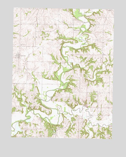
Camden Point, MO USGS Topographic Map
Click on map above to begin viewing in our Map Viewer.

This topographic map contains these locations and features:
Feature Name Type Latitude Longitude GNIS ID View Map
Alger CreekStreamN39.4106°W94.7088°713204View Map
Assembly of God ChurchChurchN39.3761°W94.7136°713457View Map
Bell CreekStreamN39.4708°W94.6680°730055View Map
Buckeye SchoolSchoolN39.4053°W94.7350°746573View Map
Camden PointPopulated PlaceN39.4528°W94.7416°715229View Map
Camden Point CemeteryCemeteryN39.4639°W94.7413°715230View Map
Camden Point Fire DepartmentBuildingN39.4533°W94.7422°2621741View Map
Camden Point Post OfficePost OfficeN39.4539°W94.7429°2779496View Map
Centenary Church (historical)ChurchN39.4131°W94.6572°742363View Map
Chinn CemeteryCemeteryN39.3928°W94.7133°715794View Map
City of Camden PointCivilN39.4542°W94.7485°2393510View Map
Clear BranchStreamN39.3808°W94.7472°715923View Map
Cockerill LakeLakeN39.4360°W94.6667°739627View Map
Cockrell CemeteryCemeteryN39.4336°W94.6758°716061View Map
Collins SchoolSchoolN39.4056°W94.6291°742364View Map
Dicks CreekStreamN39.4456°W94.6788°730086View Map
Edgerton JunctionPopulated PlaceN39.4775°W94.6750°755547View Map
Farmer CemeteryCemeteryN39.3755°W94.7052°717852View Map
Franklin SchoolSchoolN39.4189°W94.6711°742361View Map
Goose NeckCapeN39.4025°W94.6902°718601View Map
Grove CreekStreamN39.4933°W94.6655°718901View Map
Horn SchoolSchoolN39.4189°W94.6300°742362View Map
Hughes LakeLakeN39.3778°W94.6385°719975View Map
Junction Bridge (historical)BridgeN39.4797°W94.6588°746575View Map
Junction Lake (historical)LakeN39.4844°W94.6627°739515View Map
KerrvillePopulated PlaceN39.3783°W94.6952°740983View Map
Little Platte ChurchChurchN39.4200°W94.6477°721298View Map
Little Platte RiverStreamN39.3981°W94.6911°729536View Map
Lutes CemeteryCemeteryN39.4111°W94.6833°721680View Map
Malcolm Lake (historical)LakeN39.4739°W94.6583°739516View Map
McComas CemeteryCemeteryN39.3969°W94.6691°722052View Map
Mellon BridgeBridgeN39.4117°W94.7136°755312View Map
Mount Zion CemeteryCemeteryN39.4853°W94.6438°722937View Map
Mount Zion School (historical)SchoolN39.4844°W94.6388°746574View Map
Muddy BranchStreamN39.3983°W94.6744°723030View Map
Owl CreekStreamN39.4431°W94.6613°723919View Map
Pleasant View SchoolSchoolN39.4850°W94.6891°746571View Map
Ridgeley CemeteryCemeteryN39.4605°W94.6408°742359View Map
RidgelyPopulated PlaceN39.4556°W94.6386°725295View Map
Shanks BranchStreamN39.4389°W94.6861°739513View Map
Sharps StationLocaleN39.4050°W94.7294°730211View Map
Skinner BridgeBridgeN39.4481°W94.6822°742360View Map
Skinner LakeLakeN39.4339°W94.6943°739514View Map
Slash ValleyValleyN39.4769°W94.6644°759632View Map
Smith CemeteryCemeteryN39.4164°W94.6480°726601View Map
Smitty's LandingAirportN39.4452°W94.6640°758892View Map
Standiford CemeteryCemeteryN39.4994°W94.6291°742358View Map
Styne SchoolSchoolN39.4347°W94.7316°746572View Map
Swamp School (historical)SchoolN39.4531°W94.6791°746576View Map
Todd CreekStreamN39.3931°W94.6550°727690View Map
Township of GreenCivilN39.4862°W94.7488°767199View Map
Township of PrestonCivilN39.4562°W94.6403°767206View Map
Turners LakeLakeN39.3958°W94.6582°727909View Map
Village of RidgelyCivilN39.4537°W94.6402°2399072View Map

Note: Coordinates in the location and feature list above are referenced to NAD83 datum.


Copyright (C) 2008-2024 Ryan Niemi / Sunset Dynamics ... All Rights Reserved