TopoQuest Logo
Do you find TopoQuest useful?
Help keep TopoQuest running and adding new maps/features by donating!
Bitcoin:  19c7KJd3qBynnjoSw5npx9KScwjBe4ifkT
Litecoin:  LXs6TkuXGGXo1vDsWCkWVdjQX94eUKd6ui
Home View Maps Find Maps Find Places Resources & Links


Pleasant Hope, Missouri Topographic Map

USGS Map Title: Pleasant Hope, MO
USGS Map MRC: 37093D3
DRG (GeoTIFF) Download: o37093d3.tif


Neighboring USGS Topographic Map Quads:


  Bolivar, MO  
37093E4
 

  Cedar Vista, MO  
37093E3
 

  Halfway, MO  
37093E2
 

  Morrisville, MO  
37093D4
 

  Pleasant Hope, MO  
37093D3
 

  Fair Grove, MO  
37093D2
 

  Willard, MO  
37093C4
 

  Ebenezer, MO  
37093C3
 

  Bassville, MO  
37093C2


Map MRC Location:

N38°
W94°
N38°
W93°
H8 H7 H6 H5 H4 H3 H2 H1
G8 G7 G6 G5 G4 G3 G2 G1
F8 F7 F6 F5 F4 F3 F2 F1
E8 E7 E6 E5 E4 E3 E2 E1
D8 D7 D6 D5 D4 D3 D2 D1
C8 C7 C6 C5 C4 C3 C2 C1
B8 B7 B6 B5 B4 B3 B2 B1
A8 A7 A6 A5 A4 A3 A2 A1
N37°
W94°
N37°
W93°

Pleasant Hope, MO USGS 1:24K Topographic Map Preview:
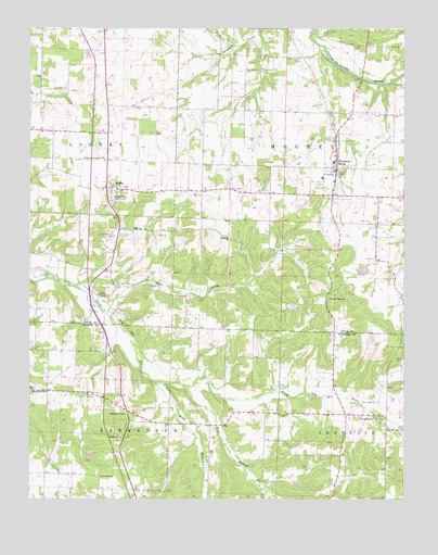
Pleasant Hope, MO USGS Topographic Map
Click on map above to begin viewing in our Map Viewer.

This topographic map contains these locations and features:
Feature Name Type Latitude Longitude GNIS ID View Map
AlsupPopulated PlaceN37.3981°W93.3055°740526View Map
Bear CreekStreamN37.4239°W93.3494°713786View Map
BrightonPopulated PlaceN37.4578°W93.3480°714704View Map
Brighton CemeteryCemeteryN37.4562°W93.3433°2702680View Map
Brighton Post OfficePost OfficeN37.4586°W93.3483°2782622View Map
Brighton School (historical)SchoolN37.4645°W93.3502°732790View Map
Chester Jenkins LakeReservoirN37.4357°W93.2638°763742View Map
Church of ChristChurchN37.3975°W93.3430°715834View Map
City of Pleasant HopeCivilN37.4650°W93.2742°2396232View Map
Good Samaritan RanchLocaleN37.4448°W93.3466°718558View Map
HeadyPopulated PlaceN37.3853°W93.3682°740525View Map
Highway Assembly ChurchChurchN37.4650°W93.3502°719591View Map
Hogue Farm AirportAirportN37.3779°W93.3614°758999View Map
Horse CreekStreamN37.4953°W93.3063°719848View Map
Johnston School (historical)SchoolN37.4295°W93.3527°732791View Map
King BranchStreamN37.4062°W93.3338°754972View Map
Lee School (historical)SchoolN37.4945°W93.3507°732789View Map
Lone Star ChurchChurchN37.3812°W93.3513°721470View Map
McNerney Lake DamDamN37.4367°W93.2619°763741View Map
Morrisville Fire and Rescue Station 4BuildingN37.4725°W93.3505°2621581View Map
Morrisville Fire and Rescue Station 7BuildingN37.4285°W93.3517°2620801View Map
New Hope CemeteryCemeteryN37.4006°W93.2591°723230View Map
New Hope SchoolSchoolN37.3967°W93.2605°723267View Map
Noble Hill ChurchChurchN37.3909°W93.3441°723393View Map
Pender ChapelChurchN37.4292°W93.3521°724194View Map
Pleasant Grove School (historical)SchoolN37.4706°W93.3169°732792View Map
Pleasant HopePopulated PlaceN37.4631°W93.2727°735789View Map
Pleasant Hope CemeteryCemeteryN37.4706°W93.2759°2702685View Map
Pleasant Hope ChurchChurchN37.4281°W93.2755°724564View Map
Pleasant Hope Fire and Rescue AssociationBuildingN37.4659°W93.2732°2620923View Map
Pleasant Hope Police DepartmentBuildingN37.4512°W93.2738°2752360View Map
Pleasant Hope Post OfficePost OfficeN37.4625°W93.2731°2782615View Map
Ralph Brooks ReservoirReservoirN37.4989°W93.3471°762971View Map
Sims BranchStreamN37.4050°W93.3238°726476View Map
Spring Hill ChurchChurchN37.4034°W93.3694°726924View Map
Spring Hill School (historical)SchoolN37.4142°W93.3735°732644View Map
Swadley School (historical)SchoolN37.3950°W93.3155°732645View Map
Tiller CemeteryCemeteryN37.4486°W93.2616°727657View Map
Township of East LooneyCivilN37.4798°W93.3624°767212View Map
Township of MooneyCivilN37.4771°W93.2536°767219View Map
Township of Robberson Number 1 (historical)CivilN37.3856°W93.3257°766692View Map
Township of Robberson Number 1BCivilN37.3955°W93.2899°1990075View Map

Note: Coordinates in the location and feature list above are referenced to NAD83 datum.


Copyright (C) 2008-2024 Ryan Niemi / Sunset Dynamics ... All Rights Reserved