TopoQuest Logo
Do you find TopoQuest useful?
Help keep TopoQuest running and adding new maps/features by donating!
Bitcoin:  19c7KJd3qBynnjoSw5npx9KScwjBe4ifkT
Litecoin:  LXs6TkuXGGXo1vDsWCkWVdjQX94eUKd6ui
Home View Maps Find Maps Find Places Resources & Links


Pleasantville, Tennessee Topographic Map

USGS Map Title: Pleasantville, TN
USGS Map MRC: 35087F6
DRG (GeoTIFF) Download: o35087f6.tif


Neighboring USGS Topographic Map Quads:


  Lobelville, TN  
35087G7
 

  Coble, TN  
35087G6
 

  Whitfield, TN  
35087G5
 

  Chestnut Grove, TN  
35087F7
 

  Pleasantville, TN  
35087F6
 

  Beaverdam Springs, TN  
35087F5
 

  Linden, TN  
35087E7
 

  Graves Spring, TN  
35087E6
 

  Hohenwald, TN  
35087E5


Map MRC Location:

N36°
W88°
N36°
W87°
H8 H7 H6 H5 H4 H3 H2 H1
G8 G7 G6 G5 G4 G3 G2 G1
F8 F7 F6 F5 F4 F3 F2 F1
E8 E7 E6 E5 E4 E3 E2 E1
D8 D7 D6 D5 D4 D3 D2 D1
C8 C7 C6 C5 C4 C3 C2 C1
B8 B7 B6 B5 B4 B3 B2 B1
A8 A7 A6 A5 A4 A3 A2 A1
N35°
W88°
N35°
W87°

Pleasantville, TN USGS 1:24K Topographic Map Preview:
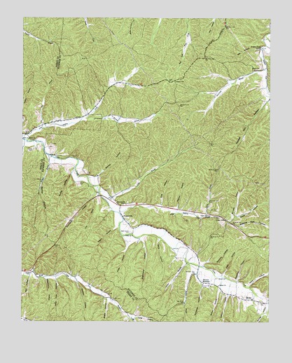
Pleasantville, TN USGS Topographic Map
Click on map above to begin viewing in our Map Viewer.

This topographic map contains these locations and features:
Feature Name Type Latitude Longitude GNIS ID View Map
Ayers CemeteryCemeteryN35.6712°W87.6553°1276023View Map
Barber HollowValleyN35.6907°W87.7354°1276284View Map
Beech Grove CemeteryCemeteryN35.6617°W87.6953°1276821View Map
Berry HollowValleyN35.6596°W87.6806°1277058View Map
Bethel CemeteryCemeteryN35.6428°W87.6508°1277109View Map
Bethel ChurchChurchN35.6398°W87.6503°1277122View Map
Bethel School (historical)SchoolN35.6403°W87.6586°1319048View Map
Brush Creek School (historical)SchoolN35.6401°W87.7181°1308558View Map
Camp Hide HollowValleyN35.6426°W87.7327°1279394View Map
Cave BranchStreamN35.6767°W87.7100°1279914View Map
Chandler HollowValleyN35.6971°W87.7490°1280234View Map
Chessor CemeteryCemeteryN35.7289°W87.6314°1305883View Map
Chessor MineMineN35.7278°W87.6353°1319060View Map
Coble HollowValleyN35.6663°W87.6453°1306009View Map
Coble Lookout TowerTowerN35.7240°W87.6734°1319062View Map
Cotham HollowValleyN35.6367°W87.6455°1281346View Map
Dan HollowValleyN35.6438°W87.7458°1282006View Map
Dickey HollowValleyN35.6388°W87.6492°1282444View Map
Dudley HollowValleyN35.6860°W87.7252°1283066View Map
Duncan CemeteryCemeteryN35.6340°W87.7039°1283150View Map
Edwards CemeteryCemeteryN35.6326°W87.6292°1283546View Map
Elkins CemeteryCemeteryN35.6823°W87.7214°1283651View Map
Enon ChurchChurchN35.7001°W87.7467°1283811View Map
Fairview ChurchChurchN35.6345°W87.6334°1284010View Map
Falls HollowValleyN35.6446°W87.6484°1284112View Map
Farmers ExchangeLocaleN35.6406°W87.6581°1284142View Map
Gladden HollowValleyN35.6417°W87.7223°1285468View Map
Goodman HollowValleyN35.6419°W87.6414°1285644View Map
Hickman County Rescue Squad Station 3BuildingN35.6692°W87.6566°2654228View Map
Hurricane BranchStreamN35.7295°W87.6270°1288783View Map
Jones BranchStreamN35.6784°W87.7114°1289695View Map
Jones HollowValleyN35.6582°W87.6959°1289799View Map
King HollowValleyN35.6727°W87.6796°1290222View Map
Kitchen HollowValleyN35.6723°W87.6715°1290318View Map
Long HollowValleyN35.6270°W87.6927°1291967View Map
Lynch HollowValleyN35.6494°W87.6675°1292340View Map
McClearen HollowValleyN35.6406°W87.6588°1293154View Map
Mill HollowValleyN35.7378°W87.6295°1293872View Map
Morgan BranchStreamN35.7070°W87.7217°1294349View Map
Murray HollowValleyN35.6327°W87.6259°1295144View Map
Negro HollowValleyN35.6641°W87.7021°1295339View Map
Pace HollowValleyN35.6400°W87.6355°1296637View Map
PleasantvillePopulated PlaceN35.6670°W87.6984°1315746View Map
Pleasantville Post OfficePost OfficeN35.6726°W87.6792°1651182View Map
Pleasantville SchoolSchoolN35.6731°W87.6975°1297962View Map
Powder Mill HollowValleyN35.7167°W87.6256°1298384View Map
Quails CemeteryCemeteryN35.6445°W87.7453°1298732View Map
Rickman HollowValleyN35.6498°W87.6559°1299383View Map
Rumsey HollowValleyN35.6684°W87.6420°1300247View Map
Salmon BranchStreamN35.6934°W87.7367°1300584View Map
Sam BranchStreamN35.7045°W87.7395°1300617View Map
Sheep HollowValleyN35.6336°W87.7061°1269960View Map
Shelving Rock HollowValleyN35.6643°W87.6407°1303562View Map
Skelton BranchStreamN35.6478°W87.6606°1270427View Map
Stanley CemeteryCemeteryN35.6956°W87.7447°1271239View Map
Stanley HollowValleyN35.6841°W87.7126°1271245View Map
Sugarcamp HollowValleyN35.6428°W87.7379°1271714View Map
Sugarcamp HollowValleyN35.6590°W87.6898°1271715View Map
Sulphur Creek ChurchChurchN35.7370°W87.6300°1271779View Map
Sulphur Creek School (historical)SchoolN35.7376°W87.6306°1319135View Map
Sulphur Springs (historical)Populated PlaceN35.7367°W87.6303°1311377View Map
Terrell BranchStreamN35.6681°W87.6578°1272328View Map
Thompson HollowValleyN35.6777°W87.7117°1304082View Map
Upper SinkingPopulated PlaceN35.6670°W87.6467°1314445View Map
Upper Sinking ChurchChurchN35.6692°W87.6550°1273308View Map
Upper Sinking CreekStreamN35.6698°W87.7011°1273309View Map
Upper Sinking School (historical)SchoolN35.6673°W87.6470°1319144View Map
Williams CemeteryCemeteryN35.6684°W87.6503°1274647View Map

Note: Coordinates in the location and feature list above are referenced to NAD83 datum.


Copyright (C) 2008-2024 Ryan Niemi / Sunset Dynamics ... All Rights Reserved