TopoQuest Logo
Do you find TopoQuest useful?
Help keep TopoQuest running and adding new maps/features by donating!
Bitcoin:  19c7KJd3qBynnjoSw5npx9KScwjBe4ifkT
Litecoin:  LXs6TkuXGGXo1vDsWCkWVdjQX94eUKd6ui
Home View Maps Find Maps Find Places Resources & Links


Big Lake, Missouri Topographic Map

USGS Map Title: Big Lake, MO
USGS Map MRC: 40095A3
DRG (GeoTIFF) Download: o40095a3.tif


Neighboring USGS Topographic Map Quads:


  Corning, MO  
40095B4
 

  Craig, MO  
40095B3
 

  Mound City, MO  
40095B2
 

  Rulo, NE  
40095A4
 

  Big Lake, MO  
40095A3
 

  Kimsey Creek, MO  
40095A2
 

  Highland NW, KS  
39095H4
 

  White Cloud, KS  
39095H3
 

  Oregon, MO  
39095H2


Map MRC Location:

N41°
W96°
N41°
W95°
H8 H7 H6 H5 H4 H3 H2 H1
G8 G7 G6 G5 G4 G3 G2 G1
F8 F7 F6 F5 F4 F3 F2 F1
E8 E7 E6 E5 E4 E3 E2 E1
D8 D7 D6 D5 D4 D3 D2 D1
C8 C7 C6 C5 C4 C3 C2 C1
B8 B7 B6 B5 B4 B3 B2 B1
A8 A7 A6 A5 A4 A3 A2 A1
N40°
W96°
N40°
W95°

Big Lake, MO USGS 1:24K Topographic Map Preview:
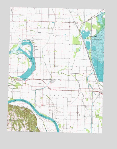
Big Lake, MO USGS Topographic Map
Click on map above to begin viewing in our Map Viewer.

This topographic map contains these locations and features:
Feature Name Type Latitude Longitude GNIS ID View Map
Big LakeLakeN40.0597°W95.3467°737863View Map
Big LakePopulated PlaceN40.0819°W95.3500°1669587View Map
Big Lake State ParkParkN40.0847°W95.3430°737864View Map
BigelowPopulated PlaceN40.1106°W95.2897°730058View Map
Cottonwood School (historical)SchoolN40.1108°W95.3339°730075View Map
Davis Creek DitchStreamN40.0306°W95.2628°736162View Map
Elm Grove School (historical)SchoolN40.0742°W95.3119°717522View Map
Exodus School (historical)SchoolN40.0158°W95.2650°717714View Map
FortescuePopulated PlaceN40.0522°W95.3183°718111View Map
Glendale School (historical)SchoolN40.1033°W95.3730°718510View Map
Idlewild School (historical)SchoolN40.0258°W95.3025°720072View Map
Main PoolReservoirN40.0517°W95.2503°760696View Map
Mallard MarshLakeN40.0992°W95.2760°754154View Map
NapierPopulated PlaceN40.0489°W95.2578°723114View Map
Nemaha BendsBendN40.0314°W95.3546°736107View Map
Nohart (historical)Populated PlaceN40.0107°W95.3697°2740653View Map
Nohart Post Office (historical)Post OfficeN40.0111°W95.3697°1883516View Map
Old Channel Little Tarkio CreekStreamN40.0161°W95.2641°738370View Map
Old Channel Tarkio RiverStreamN40.0217°W95.3150°723738View Map
Pelican PoolLakeN40.0644°W95.2553°754157View Map
Pintail PoolLakeN40.0884°W95.2715°754155View Map
Sixth Principal Meridian Historical MarkerParkN40.0028°W95.3336°1883660View Map
Snow Goose PoolLakeN40.0855°W95.2636°754156View Map
South LeveeDamN40.0517°W95.2503°760695View Map
Squaw BendBendN40.0067°W95.3103°736108View Map
Squaw Creek DitchCanalN40.0844°W95.2678°726977View Map
Town of FortescueCivilN40.0519°W95.3176°2396942View Map
Township of BigelowCivilN40.1006°W95.3229°766762View Map
Township of MintonCivilN40.0445°W95.3220°766770View Map
Village of Big LakeCivilN40.0735°W95.3518°2398117View Map
Village of BigelowCivilN40.1098°W95.2894°2398120View Map
Walnut Grove School (historical)SchoolN40.0431°W95.2764°728317View Map

Note: Coordinates in the location and feature list above are referenced to NAD83 datum.


Copyright (C) 2008-2024 Ryan Niemi / Sunset Dynamics ... All Rights Reserved