TopoQuest Logo
Do you find TopoQuest useful?
Help keep TopoQuest running and adding new maps/features by donating!
Bitcoin:  19c7KJd3qBynnjoSw5npx9KScwjBe4ifkT
Litecoin:  LXs6TkuXGGXo1vDsWCkWVdjQX94eUKd6ui
Home View Maps Find Maps Find Places Resources & Links


White Cloud, Kansas Topographic Map

USGS Map Title: White Cloud, KS
USGS Map MRC: 39095H3
DRG (GeoTIFF) Download: o39095h3.tif


Neighboring USGS Topographic Map Quads:


  Rulo, NE  
40095A4
 

  Big Lake, MO  
40095A3
 

  Kimsey Creek, MO  
40095A2
 

  Highland NW, KS  
39095H4
 

  White Cloud, KS  
39095H3
 

  Oregon, MO  
39095H2
 

  Robinson, KS  
39095G4
 

  Highland, KS  
39095G3
 

  Sparks, KS  
39095G2


Map MRC Location:

N40°
W96°
N40°
W95°
H8 H7 H6 H5 H4 H3 H2 H1
G8 G7 G6 G5 G4 G3 G2 G1
F8 F7 F6 F5 F4 F3 F2 F1
E8 E7 E6 E5 E4 E3 E2 E1
D8 D7 D6 D5 D4 D3 D2 D1
C8 C7 C6 C5 C4 C3 C2 C1
B8 B7 B6 B5 B4 B3 B2 B1
A8 A7 A6 A5 A4 A3 A2 A1
N39°
W96°
N39°
W95°

White Cloud, KS USGS 1:24K Topographic Map Preview:
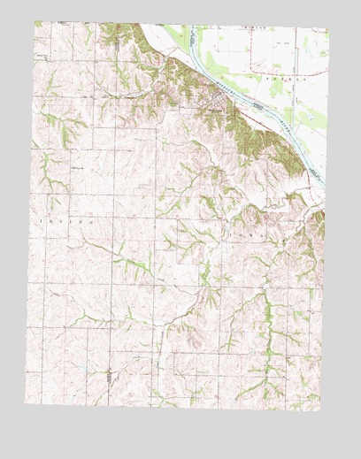
White Cloud, KS USGS Topographic Map
Click on map above to begin viewing in our Map Viewer.

This topographic map contains these locations and features:
Feature Name Type Latitude Longitude GNIS ID View Map
Arnold School (historical)SchoolN39.9367°W95.3125°482886View Map
Burr Oak School (historical)SchoolN39.9850°W95.2747°747052View Map
Cedar CreekStreamN39.9478°W95.2511°472796View Map
Cedar Creek School (historical)SchoolN39.8933°W95.3214°482890View Map
City of White CloudCivilN39.9744°W95.2990°2397301View Map
Fairview School (historical)SchoolN39.9144°W95.2844°482894View Map
Fivemile LaneCanalN39.9819°W95.2644°721333View Map
Fox CreekStreamN39.8908°W95.3191°472797View Map
Frog College School (historical)SchoolN39.8861°W95.2728°482895View Map
Grand View SchoolSchoolN39.9872°W95.3722°472801View Map
Hill Top SchoolSchoolN39.9522°W95.3583°472805View Map
Iowa Tribal Police DepartmentBuildingN39.9888°W95.3688°2504118View Map
Iowa Tribe of Kansas and Nebraska Fire DepartmentBuildingN39.9875°W95.3686°2111445View Map
Nolands CreekStreamN39.9922°W95.3136°472800View Map
Olive Branch CemeteryCemeteryN39.9735°W95.3162°472804View Map
Partlow CemeteryCemeteryN39.9998°W95.3602°472802View Map
Spring CreekStreamN39.9133°W95.3028°472798View Map
Tesson CemeteryCemeteryN39.9766°W95.3413°472803View Map
Township of IowaCivilN39.8943°W95.2612°472806View Map
White CloudPopulated PlaceN39.9764°W95.2969°472799View Map
White Cloud Post OfficePost OfficeN39.9773°W95.2968°2694024View Map
Zion United Methodist ChurchChurchN39.9303°W95.3581°472791View Map

Note: Coordinates in the location and feature list above are referenced to NAD83 datum.


Copyright (C) 2008-2024 Ryan Niemi / Sunset Dynamics ... All Rights Reserved