TopoQuest Logo
Do you find TopoQuest useful?
Help keep TopoQuest running and adding new maps/features by donating!
Bitcoin:  19c7KJd3qBynnjoSw5npx9KScwjBe4ifkT
Litecoin:  LXs6TkuXGGXo1vDsWCkWVdjQX94eUKd6ui
Home View Maps Find Maps Find Places Resources & Links


Reserve, Kansas Topographic Map

USGS Map Title: Reserve, KS
USGS Map MRC: 39095H5
DRG (GeoTIFF) Download: o39095h5.tif


Neighboring USGS Topographic Map Quads:


  Salem, NE  
40095A6
 

  Falls City, NE  
40095A5
 

  Rulo, NE  
40095A4
 

  Morrill, KS  
39095H6
 

  Reserve, KS  
39095H5
 

  Highland NW, KS  
39095H4
 

  Fairview, KS  
39095G6
 

  Hiawatha, KS  
39095G5
 

  Robinson, KS  
39095G4


Map MRC Location:

N40°
W96°
N40°
W95°
H8 H7 H6 H5 H4 H3 H2 H1
G8 G7 G6 G5 G4 G3 G2 G1
F8 F7 F6 F5 F4 F3 F2 F1
E8 E7 E6 E5 E4 E3 E2 E1
D8 D7 D6 D5 D4 D3 D2 D1
C8 C7 C6 C5 C4 C3 C2 C1
B8 B7 B6 B5 B4 B3 B2 B1
A8 A7 A6 A5 A4 A3 A2 A1
N39°
W96°
N39°
W95°

Reserve, KS USGS 1:24K Topographic Map Preview:
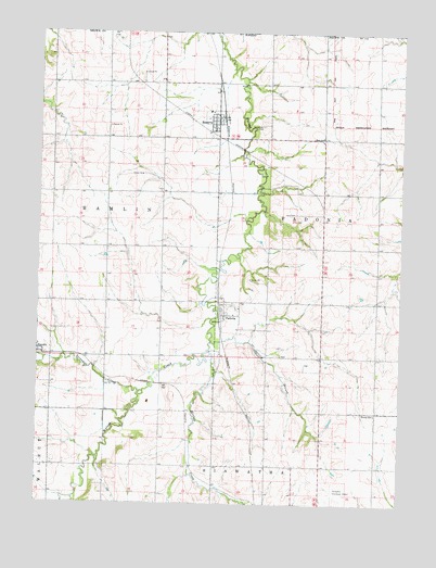
Reserve, KS USGS Topographic Map
Click on map above to begin viewing in our Map Viewer.

This topographic map contains these locations and features:
Feature Name Type Latitude Longitude GNIS ID View Map
Agricultural Partners Co - Operative Grain Elevator Number 4LocaleN39.9242°W95.5624°2695134View Map
Agricultural Partners Co - Operative Grain Elevator Number 6LocaleN39.9770°W95.5623°2695136View Map
City of ReserveCivilN39.9770°W95.5652°2396354View Map
Cornelison CemeteryCemeteryN39.9753°W95.5485°2673208View Map
Euchre CreekStreamN39.9147°W95.5658°472779View Map
Hart CemeteryCemeteryN39.9519°W95.5369°472786View Map
Hart SchoolSchoolN39.9725°W95.5278°472785View Map
Hiawatha Mennonite ChurchChurchN39.8863°W95.5627°2689722View Map
Hiawatha Municipal AirportAirportN39.8792°W95.5253°472781View Map
PadoniaPopulated PlaceN39.9233°W95.5628°472783View Map
ReservePopulated PlaceN39.9772°W95.5619°472784View Map
Reserve Elementary SchoolSchoolN39.9789°W95.5667°480184View Map
Sac and Fox Tribal Police DepartmentBuildingN39.9788°W95.5670°2503924View Map
Spring BranchStreamN39.9178°W95.5658°472780View Map
Terrapin CreekStreamN39.9044°W95.5889°472772View Map
Township of HamlinCivilN39.9496°W95.6193°472776View Map
Township of PadoniaCivilN39.9498°W95.5079°472787View Map
Victory SchoolSchoolN39.8989°W95.5089°472782View Map

Note: Coordinates in the location and feature list above are referenced to NAD83 datum.


Copyright (C) 2008-2024 Ryan Niemi / Sunset Dynamics ... All Rights Reserved