TopoQuest Logo
Do you find TopoQuest useful?
Help keep TopoQuest running and adding new maps/features by donating!
Bitcoin:  19c7KJd3qBynnjoSw5npx9KScwjBe4ifkT
Litecoin:  LXs6TkuXGGXo1vDsWCkWVdjQX94eUKd6ui
Home View Maps Find Maps Find Places Resources & Links


Salisbury, Illinois Topographic Map

USGS Map Title: Salisbury, IL
USGS Map MRC: 39089H7
DRG (GeoTIFF) Download: o39089h7.tif


Neighboring USGS Topographic Map Quads:


  Oakford, IL  
40089A8
 

  Petersburg, IL  
40089A7
 

  Greenview, IL  
40089A6
 

  Tallula, IL  
39089H8
 

  Salisbury, IL  
39089H7
 

  Athens, IL  
39089H6
 

  Pleasant Plains, IL  
39089G8
 

  Farmingdale, IL  
39089G7
 

  Springfield West, IL  
39089G6


Map MRC Location:

N40°
W90°
N40°
W89°
H8 H7 H6 H5 H4 H3 H2 H1
G8 G7 G6 G5 G4 G3 G2 G1
F8 F7 F6 F5 F4 F3 F2 F1
E8 E7 E6 E5 E4 E3 E2 E1
D8 D7 D6 D5 D4 D3 D2 D1
C8 C7 C6 C5 C4 C3 C2 C1
B8 B7 B6 B5 B4 B3 B2 B1
A8 A7 A6 A5 A4 A3 A2 A1
N39°
W90°
N39°
W89°

Salisbury, IL USGS 1:24K Topographic Map Preview:
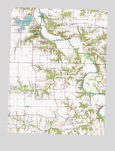
Salisbury, IL USGS Topographic Map
Click on map above to begin viewing in our Map Viewer.

This topographic map contains these locations and features:
Feature Name Type Latitude Longitude GNIS ID View Map
Farmers Point CemeteryCemeteryN39.9431°W89.8448°408282View Map
Halls BranchStreamN39.9603°W89.7876°409671View Map
Harrison CemeteryCemeteryN39.8928°W89.8307°409858View Map
Hickory Grove CemeteryCemeteryN39.9484°W89.8168°410151View Map
Hopwood CemeteryCemeteryN39.9035°W89.7559°410533View Map
Kelso Hollow AmphitheaterLocaleN39.9792°W89.8473°1808805View Map
Lake PetersburgReservoirN39.9856°W89.8571°415579View Map
Lake PetersburgPopulated PlaceN39.9836°W89.8621°2629895View Map
Lake Petersburg Census Designated PlaceCensusN39.9832°W89.8655°2629866View Map
Lake Petersburg DamDamN39.9881°W89.8482°1691604View Map
LewisburgPopulated PlaceN39.9700°W89.8326°411976View Map
Lincolns New Salem State ParkParkN39.9753°W89.8418°412216View Map
LoydPopulated PlaceN39.9148°W89.8543°1748058View Map
New Salem (historical)Populated PlaceN39.9789°W89.8440°1808808View Map
Old Grist MillLocaleN39.9806°W89.8387°415020View Map
Old Salem ChautauquaPopulated PlaceN39.9923°W89.8354°415054View Map
Petersburg East Number 13 Election PrecinctCivilN39.9999°W89.8019°1928589View Map
Prairie CreekStreamN39.8850°W89.7698°416122View Map
Richland Baptist CemeteryCemeteryN39.8909°W89.8745°1821101View Map
Richland ChurchChurchN39.8914°W89.8743°416602View Map
Richland CreekStreamN39.9145°W89.7659°416607View Map
Rock CreekStreamN39.9537°W89.7718°416799View Map
Rock Creek Number 12 Election PrecinctCivilN39.9311°W89.8277°1928634View Map
Rock Creek Presbyterian ChurchChurchN39.9209°W89.8657°416809View Map
Rocky BranchStreamN39.9767°W89.8368°416866View Map
Rutledge-Camron Saw and Grist MillLocaleN39.9806°W89.8382°1808815View Map
SalisburyPopulated PlaceN39.8898°W89.7982°417892View Map
Salisbury CemeteryCemeteryN39.8950°W89.7973°417893View Map
Shambolee Golf ClubLocaleN39.9823°W89.8698°425472View Map
Shamual Manor Nursing HomeBuildingN39.9925°W89.8271°418276View Map
Sunny Acres Nursing HomeBuildingN39.9998°W89.8271°419379View Map
TicePopulated PlaceN39.9853°W89.7948°423240View Map
Town BranchStreamN39.9562°W89.7762°419803View Map
Township of Salisbury (historical)CivilN39.8959°W89.7654°1785072View Map

Note: Coordinates in the location and feature list above are referenced to NAD83 datum.


Copyright (C) 2008-2024 Ryan Niemi / Sunset Dynamics ... All Rights Reserved