TopoQuest Logo
Do you find TopoQuest useful?
Help keep TopoQuest running and adding new maps/features by donating!
Bitcoin:  19c7KJd3qBynnjoSw5npx9KScwjBe4ifkT
Litecoin:  LXs6TkuXGGXo1vDsWCkWVdjQX94eUKd6ui
Home View Maps Find Maps Find Places Resources & Links


Sango, Tennessee Topographic Map

USGS Map Title: Sango, TN
USGS Map MRC: 36087E2
DRG (GeoTIFF) Download: o36087e2.tif


Neighboring USGS Topographic Map Quads:


  Trenton, KY  
36087F3
 

  Guthrie, KY  
36087F2
 

  Allensville, KY  
36087F1
 

  Clarksville, TN  
36087E3
 

  Sango, TN  
36087E2
 

  Adams, TN  
36087E1
 

  Excell, TN  
36087D3
 

  Henrietta, TN  
36087D2
 

  Pleasant View, TN  
36087D1


Map MRC Location:

N37°
W88°
N37°
W87°
H8 H7 H6 H5 H4 H3 H2 H1
G8 G7 G6 G5 G4 G3 G2 G1
F8 F7 F6 F5 F4 F3 F2 F1
E8 E7 E6 E5 E4 E3 E2 E1
D8 D7 D6 D5 D4 D3 D2 D1
C8 C7 C6 C5 C4 C3 C2 C1
B8 B7 B6 B5 B4 B3 B2 B1
A8 A7 A6 A5 A4 A3 A2 A1
N36°
W88°
N36°
W87°

Sango, TN USGS 1:24K Topographic Map Preview:
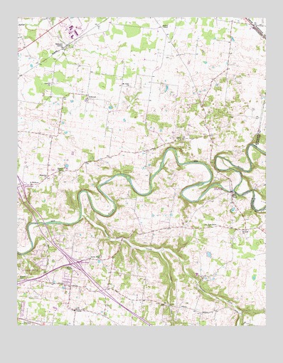
Sango, TN USGS Topographic Map
Click on map above to begin viewing in our Map Viewer.

This topographic map contains these locations and features:
Feature Name Type Latitude Longitude GNIS ID View Map
Blue Ridge FieldAirportN36.5301°W87.1767°2770302View Map
Clarksville Baptist CollegeSchoolN36.5223°W87.2206°1319602View Map
Clarksville Fire Rescue Station 2BuildingN36.5188°W87.2348°2654049View Map
Commissioner District 15CivilN36.5056°W87.2216°2464389View Map
Commissioner District 19CivilN36.6024°W87.2084°2463891View Map
Coon CreekStreamN36.5298°W87.1792°1281168View Map
Corinth ChurchChurchN36.5981°W87.2333°1281307View Map
Countryside EstatesPopulated PlaceN36.5175°W87.2250°1311482View Map
District 1 (historical)CivilN36.6000°W87.1833°1325925View Map
District 5 (historical)CivilN36.5334°W87.1583°1325929View Map
Hampton StationPopulated PlaceN36.6137°W87.2256°1286709View Map
Hollins ChapelChurchN36.6217°W87.1775°1288071View Map
Interchange 11CrossingN36.5253°W87.2211°1311512View Map
Interchange 8CrossingN36.5562°W87.2486°1311511View Map
KirkwoodPopulated PlaceN36.5934°W87.2153°1290310View Map
Kirkwood Baptist ChurchChurchN36.5937°W87.2156°1319656View Map
Kirkwood School (historical)SchoolN36.5934°W87.2144°1319657View Map
Little Hope ChurchChurchN36.5278°W87.2078°1291529View Map
Mount Nebo ChurchChurchN36.5975°W87.1942°1294687View Map
Mount Zion Baptist ChurchChurchN36.5384°W87.1369°1294921View Map
Nevel ChapelChurchN36.5239°W87.2256°1295411View Map
Olive ChurchChurchN36.5756°W87.1675°1296410View Map
Passenger CreekStreamN36.5450°W87.2181°1296909View Map
Paula HeightsPopulated PlaceN36.5303°W87.2375°1311538View Map
Pisgah SchoolSchoolN36.5192°W87.2486°1297729View Map
Port RoyalPopulated PlaceN36.5537°W87.1419°1315767View Map
Port Royal ChurchChurchN36.5403°W87.1544°1298243View Map
Port Royal State ParkParkN36.5556°W87.1442°1647749View Map
Red River EstatesPopulated PlaceN36.5245°W87.2375°1311543View Map
Rest Haven Memorial GardensCemeteryN36.5006°W87.2422°1269283View Map
RossviewPopulated PlaceN36.5606°W87.2350°1315843View Map
Rossview School (historical)SchoolN36.5556°W87.2483°1319700View Map
Royalty AcresPopulated PlaceN36.5070°W87.2472°1311550View Map
Saint Matthews ChurchChurchN36.5567°W87.2436°1300487View Map
SangoPopulated PlaceN36.5064°W87.2208°1300782View Map
Sango School (historical)SchoolN36.5062°W87.2214°1651290View Map
Sulphur Fork Red RiverStreamN36.5548°W87.1411°1648169View Map
Whites ChapelChurchN36.5623°W87.2278°1274453View Map
WindermerePopulated PlaceN36.5350°W87.2289°1311571View Map

Note: Coordinates in the location and feature list above are referenced to NAD83 datum.


Copyright (C) 2008-2024 Ryan Niemi / Sunset Dynamics ... All Rights Reserved