TopoQuest Logo
Do you find TopoQuest useful?
Help keep TopoQuest running and adding new maps/features by donating!
Bitcoin:  19c7KJd3qBynnjoSw5npx9KScwjBe4ifkT
Litecoin:  LXs6TkuXGGXo1vDsWCkWVdjQX94eUKd6ui
Home View Maps Find Maps Find Places Resources & Links


Trenton, Kentucky Topographic Map

USGS Map Title: Trenton, KY
USGS Map MRC: 36087F3
DRG (GeoTIFF) Download: o36087f3.tif


Neighboring USGS Topographic Map Quads:


  Hopkinsville, KY  
36087G4
 

  Pembroke, KY  
36087G3
 

  Elkton, KY  
36087G2
 

  Oak Grove, KY  
36087F4
 

  Trenton, KY  
36087F3
 

  Guthrie, KY  
36087F2
 

  New Providence, TN  
36087E4
 

  Clarksville, TN  
36087E3
 

  Sango, TN  
36087E2


Map MRC Location:

N37°
W88°
N37°
W87°
H8 H7 H6 H5 H4 H3 H2 H1
G8 G7 G6 G5 G4 G3 G2 G1
F8 F7 F6 F5 F4 F3 F2 F1
E8 E7 E6 E5 E4 E3 E2 E1
D8 D7 D6 D5 D4 D3 D2 D1
C8 C7 C6 C5 C4 C3 C2 C1
B8 B7 B6 B5 B4 B3 B2 B1
A8 A7 A6 A5 A4 A3 A2 A1
N36°
W88°
N36°
W87°

Trenton, KY USGS 1:24K Topographic Map Preview:
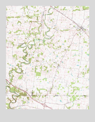
Trenton, KY USGS Topographic Map
Click on map above to begin viewing in our Map Viewer.

This topographic map contains these locations and features:
Feature Name Type Latitude Longitude GNIS ID View Map
Barkers MillPopulated PlaceN36.6681°W87.3478°507453View Map
Big Pond (historical)LakeN36.6907°W87.2517°2743140View Map
Cedar BluffCliffN36.7042°W87.3492°2742881View Map
Cedar Bluff ChurchChurchN36.7042°W87.3497°489164View Map
City of TrentonCivilN36.7225°W87.2629°2405601View Map
CloverlandsBuildingN36.6389°W87.3267°1319611View Map
Commissioner District 18CivilN36.6344°W87.3331°2464410View Map
Dry BranchStreamN36.7250°W87.2522°491156View Map
Edgewood CemeteryCemeteryN36.7250°W87.2697°491563View Map
Interchange 1CrossingN36.6300°W87.3167°1311509View Map
Montgomery CreekStreamN36.7095°W87.3292°498509View Map
Peachers MillLocaleN36.6259°W87.3656°1319690View Map
Pisgah ChurchChurchN36.6817°W87.2992°500763View Map
Reins Lick CreekStreamN36.7456°W87.2686°501721View Map
TrentonPopulated PlaceN36.7239°W87.2628°505487View Map
Trenton DivisionCivilN36.7154°W87.2613°1937294View Map
Trenton Volunteer Fire DepartmentBuildingN36.7230°W87.2627°2636964View Map
Woodward CemeteryCemeteryN36.6911°W87.3392°507128View Map
ZionPopulated PlaceN36.6778°W87.2958°509427View Map

Note: Coordinates in the location and feature list above are referenced to NAD83 datum.


Copyright (C) 2008-2024 Ryan Niemi / Sunset Dynamics ... All Rights Reserved