TopoQuest Logo
Do you find TopoQuest useful?
Help keep TopoQuest running and adding new maps/features by donating!
Bitcoin:  19c7KJd3qBynnjoSw5npx9KScwjBe4ifkT
Litecoin:  LXs6TkuXGGXo1vDsWCkWVdjQX94eUKd6ui
Home View Maps Find Maps Find Places Resources & Links


Smithfield, Illinois Topographic Map

USGS Map Title: Smithfield, IL
USGS Map MRC: 40090D3
DRG (GeoTIFF) Download: o40090d3.tif


Neighboring USGS Topographic Map Quads:


  Bushnell East, IL  
40090E4
 

  Blyton, IL  
40090E3
 

  Fiatt, IL  
40090E2
 

  Adair, IL  
40090D4
 

  Smithfield, IL  
40090D3
 

  Lewistown, IL  
40090D2
 

  Vermont, IL  
40090C4
 

  Ipava, IL  
40090C3
 

  Duncan Mills, IL  
40090C2


Map MRC Location:

N41°
W91°
N41°
W90°
H8 H7 H6 H5 H4 H3 H2 H1
G8 G7 G6 G5 G4 G3 G2 G1
F8 F7 F6 F5 F4 F3 F2 F1
E8 E7 E6 E5 E4 E3 E2 E1
D8 D7 D6 D5 D4 D3 D2 D1
C8 C7 C6 C5 C4 C3 C2 C1
B8 B7 B6 B5 B4 B3 B2 B1
A8 A7 A6 A5 A4 A3 A2 A1
N40°
W91°
N40°
W90°

Smithfield, IL USGS 1:24K Topographic Map Preview:
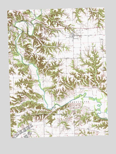
Smithfield, IL USGS Topographic Map
Click on map above to begin viewing in our Map Viewer.

This topographic map contains these locations and features:
Feature Name Type Latitude Longitude GNIS ID View Map
Badger CreekStreamN40.4570°W90.3610°403794View Map
Barker CreekStreamN40.4731°W90.3626°403901View Map
Baughman BranchStreamN40.4756°W90.3435°403970View Map
Baughman CemeteryCemeteryN40.4842°W90.2810°403972View Map
Bernadotte (historical)Populated PlaceN40.4020°W90.3204°1802136View Map
Bernadotte BridgeBridgeN40.4037°W90.3210°424633View Map
Brock School (historical)SchoolN40.4800°W90.2815°1802203View Map
Elrod Bridge (historical)BridgeN40.3914°W90.2546°424873View Map
Elrod School (historical)SchoolN40.3812°W90.2748°407967View Map
Francis CreekStreamN40.4045°W90.3276°408648View Map
Fuller CemeteryCemeteryN40.4873°W90.3385°408794View Map
Harper - Rector Woods Nature PreserveParkN40.4931°W90.3329°1993295View Map
Hawthorne School (historical)SchoolN40.3831°W90.3621°1802222View Map
Hickory Grove School (historical)SchoolN40.4298°W90.3696°1802223View Map
Howard CemeteryCemeteryN40.4523°W90.3201°1773334View Map
Howard ChurchChurchN40.4514°W90.3198°410610View Map
Howerter School (historical)SchoolN40.4798°W90.2729°410628View Map
Hull School (historical)SchoolN40.4514°W90.3012°410671View Map
Humphreys BranchStreamN40.4820°W90.3710°1802139View Map
Jones School (historical)SchoolN40.4398°W90.2537°411225View Map
Little Brick School (historical)SchoolN40.4687°W90.2535°412294View Map
Medley School (historical)SchoolN40.4623°W90.3407°413365View Map
Muddy CreekStreamN40.4114°W90.2643°414207View Map
Poverty RidgePopulated PlaceN40.4620°W90.3410°1802240View Map
Randol CemeteryCemeteryN40.4098°W90.3137°1773363View Map
Reese School (historical)SchoolN40.4217°W90.2846°416505View Map
SevillePopulated PlaceN40.4856°W90.3437°423177View Map
Seville BridgeBridgeN40.4881°W90.3523°1802138View Map
Seville School (historical)SchoolN40.4912°W90.3510°1802242View Map
Shaw CreekStreamN40.4912°W90.3393°418306View Map
SmithfieldPopulated PlaceN40.4734°W90.2918°418653View Map
Smithfield Fire Protection DistrictBuildingN40.4743°W90.2912°2640554View Map
Smithfield Post OfficePost OfficeN40.4724°W90.2914°2788730View Map
Smithfield School (historical)SchoolN40.4753°W90.2935°1802243View Map
Stites CemeteryCemeteryN40.4006°W90.3312°1773368View Map
Tartars Ferry BridgeBridgeN40.4462°W90.3504°1802137View Map
Township of BernadotteCivilN40.4084°W90.2763°428662View Map
Township of CassCivilN40.4917°W90.2795°428775View Map
Turner FarmsLocaleN40.4106°W90.3237°1802246View Map
Village of SmithfieldCivilN40.4744°W90.2949°2399831View Map
Zoll CemeteryCemeteryN40.3814°W90.3693°1984290View Map

Note: Coordinates in the location and feature list above are referenced to NAD83 datum.


Copyright (C) 2008-2024 Ryan Niemi / Sunset Dynamics ... All Rights Reserved