TopoQuest Logo
Do you find TopoQuest useful?
Help keep TopoQuest running and adding new maps/features by donating!
Bitcoin:  19c7KJd3qBynnjoSw5npx9KScwjBe4ifkT
Litecoin:  LXs6TkuXGGXo1vDsWCkWVdjQX94eUKd6ui
Home View Maps Find Maps Find Places Resources & Links


Duncan Mills, Illinois Topographic Map

USGS Map Title: Duncan Mills, IL
USGS Map MRC: 40090C2
DRG (GeoTIFF) Download: o40090c2.tif


Neighboring USGS Topographic Map Quads:


  Smithfield, IL  
40090D3
 

  Lewistown, IL  
40090D2
 

  Saint David, IL  
40090D1
 

  Ipava, IL  
40090C3
 

  Duncan Mills, IL  
40090C2
 

  Havana, IL  
40090C1
 

  Astoria, IL  
40090B3
 

  Bath, IL  
40090B2
 

  Kilbourne, IL  
40090B1


Map MRC Location:

N41°
W91°
N41°
W90°
H8 H7 H6 H5 H4 H3 H2 H1
G8 G7 G6 G5 G4 G3 G2 G1
F8 F7 F6 F5 F4 F3 F2 F1
E8 E7 E6 E5 E4 E3 E2 E1
D8 D7 D6 D5 D4 D3 D2 D1
C8 C7 C6 C5 C4 C3 C2 C1
B8 B7 B6 B5 B4 B3 B2 B1
A8 A7 A6 A5 A4 A3 A2 A1
N40°
W91°
N40°
W90°

Duncan Mills, IL USGS 1:24K Topographic Map Preview:
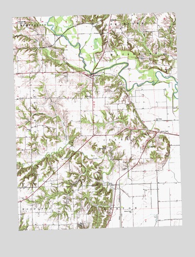
Duncan Mills, IL USGS Topographic Map
Click on map above to begin viewing in our Map Viewer.

This topographic map contains these locations and features:
Feature Name Type Latitude Longitude GNIS ID View Map
Atchley FarmsLocaleN40.3550°W90.1344°2706579View Map
BeatyPopulated PlaceN40.2750°W90.2460°422445View Map
Beaty School (historical)SchoolN40.2748°W90.2476°1802177View Map
Curless AirportAirportN40.2615°W90.2367°427861View Map
Duncan MillsPopulated PlaceN40.3400°W90.1910°407486View Map
Duncan Mills Bridge (historical)BridgeN40.3406°W90.1896°1802121View Map
Duncan Mills School (historical)SchoolN40.3270°W90.1907°407487View Map
East CreekStreamN40.3337°W90.1251°424179View Map
EnionPopulated PlaceN40.2750°W90.1773°422672View Map
Felkel School (historical)SchoolN40.3717°W90.1751°408314View Map
Fish School (historical)SchoolN40.3223°W90.1721°1802176View Map
Foutch CemeteryCemeteryN40.3045°W90.1498°408602View Map
Foutch School (historical)SchoolN40.2973°W90.1490°408604View Map
Freeman CemeteryCemeteryN40.3553°W90.2132°408726View Map
Graham School (historical)SchoolN40.2964°W90.1815°409244View Map
Haines School (historical)SchoolN40.3081°W90.2387°409616View Map
Hickory CemeteryCemeteryN40.2528°W90.2009°1773332View Map
Hickory School (historical)SchoolN40.2531°W90.2018°410188View Map
Isabel ChurchChurchN40.3250°W90.1910°1802175View Map
Kearney CemeteryCemeteryN40.2839°W90.1690°411334View Map
Kerton Valley School (historical)SchoolN40.2587°W90.1632°411432View Map
Mound ChapelChurchN40.3048°W90.1396°413905View Map
North Branch Otter CreekStreamN40.2992°W90.2118°414572View Map
Oak Ridge School (historical)SchoolN40.3717°W90.2443°414856View Map
Otto (historical)Populated PlaceN40.2987°W90.2071°1802122View Map
Otto CemeteryCemeteryN40.3006°W90.2071°415237View Map
Otto School (historical)SchoolN40.2917°W90.2101°415239View Map
Smith CemeteryCemeteryN40.3275°W90.2429°418628View Map
Tater CreekStreamN40.3425°W90.1948°419549View Map
Thomas Lake (historical)LakeN40.2848°W90.1343°1802119View Map
Township of IsabelCivilN40.3069°W90.1602°429175View Map
Turkey BranchStreamN40.2925°W90.1982°419922View Map
Waterford (historical)Populated PlaceN40.3389°W90.1298°1802174View Map
Waterford CemeteryCemeteryN40.3420°W90.1312°418215View Map
West Waterford School (historical)SchoolN40.3484°W90.1501°420945View Map
Wheaton Lake (historical)LakeN40.3503°W90.1612°1802120View Map
Wild Goose School (historical)SchoolN40.3120°W90.1429°421142View Map

Note: Coordinates in the location and feature list above are referenced to NAD83 datum.


Copyright (C) 2008-2024 Ryan Niemi / Sunset Dynamics ... All Rights Reserved