TopoQuest Logo
Do you find TopoQuest useful?
Help keep TopoQuest running and adding new maps/features by donating!
Bitcoin:  19c7KJd3qBynnjoSw5npx9KScwjBe4ifkT
Litecoin:  LXs6TkuXGGXo1vDsWCkWVdjQX94eUKd6ui
Home View Maps Find Maps Find Places Resources & Links


Snipesville, Georgia Topographic Map

USGS Map Title: Snipesville, GA
USGS Map MRC: 31082G7
DRG (GeoTIFF) Download: o31082g7.tif


Neighboring USGS Topographic Map Quads:


  Workmore, GA  
31082H8
 

  Jacksonville NE, GA  
31082H7
 

  Lumber City, GA  
31082H6
 

  Jacksonville, GA  
31082G8
 

  Snipesville, GA  
31082G7
 

  Roper, GA  
31082G6
 

  Broxton North, GA  
31082F8
 

  Broxton NE, GA  
31082F7
 

  Denton, GA  
31082F6


Map MRC Location:

N32°
W83°
N32°
W82°
H8 H7 H6 H5 H4 H3 H2 H1
G8 G7 G6 G5 G4 G3 G2 G1
F8 F7 F6 F5 F4 F3 F2 F1
E8 E7 E6 E5 E4 E3 E2 E1
D8 D7 D6 D5 D4 D3 D2 D1
C8 C7 C6 C5 C4 C3 C2 C1
B8 B7 B6 B5 B4 B3 B2 B1
A8 A7 A6 A5 A4 A3 A2 A1
N31°
W83°
N31°
W82°

Snipesville, GA USGS 1:24K Topographic Map Preview:
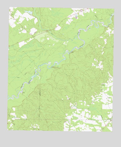
Snipesville, GA USGS Topographic Map
Click on map above to begin viewing in our Map Viewer.

This topographic map contains these locations and features:
Feature Name Type Latitude Longitude GNIS ID View Map
Ashleys Ferry (historical)CrossingN31.8324°W82.7985°335090View Map
Barrel Head Church (historical)ChurchN31.7921°W82.7635°335091View Map
Barrel Head School (historical)SchoolN31.7919°W82.7632°335092View Map
Bingham (historical)Populated PlaceN31.8188°W82.7682°335093View Map
Burket Ferry LandingLocaleN31.8696°W82.7540°331284View Map
Burketts Ferry (historical)CrossingN31.8688°W82.7518°335095View Map
Coffee BranchStreamN31.8113°W82.8424°312797View Map
Dan Bland BaySwampN31.8193°W82.8682°313278View Map
Flat Tub LandingLocaleN31.7877°W82.8576°331727View Map
Haddock LandingLocaleN31.8299°W82.8004°331891View Map
Haddocks LandingLocaleN31.8357°W82.7874°335104View Map
Hall CemeteryCemeteryN31.8507°W82.8279°315033View Map
Horse CreekStreamN31.8471°W82.7926°315688View Map
Jeff Davis County Fire Department Station 5 SnipesvilleBuildingN31.7628°W82.7510°2604485View Map
KirklandPopulated PlaceN31.7985°W82.7626°326355View Map
Montgomery LakeLakeN31.8287°W82.8115°356946View Map
Mount Galilee ChurchChurchN31.8677°W82.8735°318635View Map
Oak Hill Church (historical)ChurchN31.7774°W82.7929°335128View Map
Opossum CreekStreamN31.8696°W82.7521°320082View Map
Paceville (historical)Populated PlaceN31.7816°W82.8274°335131View Map
Piney Grove ChurchChurchN31.7827°W82.8021°320703View Map
Rocky Hammock LandingLocaleN31.8144°W82.8229°332896View Map
Saint Andrews CemeteryCemeteryN31.7516°W82.8440°322044View Map
Snipes School (historical)SchoolN31.7621°W82.7507°335139View Map
SnipesvillePopulated PlaceN31.7619°W82.7510°323192View Map
Snipesville ChurchChurchN31.7552°W82.7507°335140View Map
Union Springs ChurchChurchN31.7927°W82.7640°324583View Map
Varnadoe LakeReservoirN31.8701°W82.8509°342275View Map
Varnadoe Lake DamDamN31.8702°W82.8482°342274View Map

Note: Coordinates in the location and feature list above are referenced to NAD83 datum.


Copyright (C) 2008-2024 Ryan Niemi / Sunset Dynamics ... All Rights Reserved