TopoQuest Logo
Do you find TopoQuest useful?
Help keep TopoQuest running and adding new maps/features by donating!
Bitcoin:  19c7KJd3qBynnjoSw5npx9KScwjBe4ifkT
Litecoin:  LXs6TkuXGGXo1vDsWCkWVdjQX94eUKd6ui
Home View Maps Find Maps Find Places Resources & Links


Roper, Georgia Topographic Map

USGS Map Title: Roper, GA
USGS Map MRC: 31082G6
DRG (GeoTIFF) Download: o31082g6.tif


Neighboring USGS Topographic Map Quads:


  Jacksonville NE, GA  
31082H7
 

  Lumber City, GA  
31082H6
 

  Hazlehurst North, GA  
31082H5
 

  Snipesville, GA  
31082G7
 

  Roper, GA  
31082G6
 

  Hazlehurst South, GA  
31082G5
 

  Broxton NE, GA  
31082F7
 

  Denton, GA  
31082F6
 

  Nicholls NE, GA  
31082F5


Map MRC Location:

N32°
W83°
N32°
W82°
H8 H7 H6 H5 H4 H3 H2 H1
G8 G7 G6 G5 G4 G3 G2 G1
F8 F7 F6 F5 F4 F3 F2 F1
E8 E7 E6 E5 E4 E3 E2 E1
D8 D7 D6 D5 D4 D3 D2 D1
C8 C7 C6 C5 C4 C3 C2 C1
B8 B7 B6 B5 B4 B3 B2 B1
A8 A7 A6 A5 A4 A3 A2 A1
N31°
W83°
N31°
W82°

Roper, GA USGS 1:24K Topographic Map Preview:
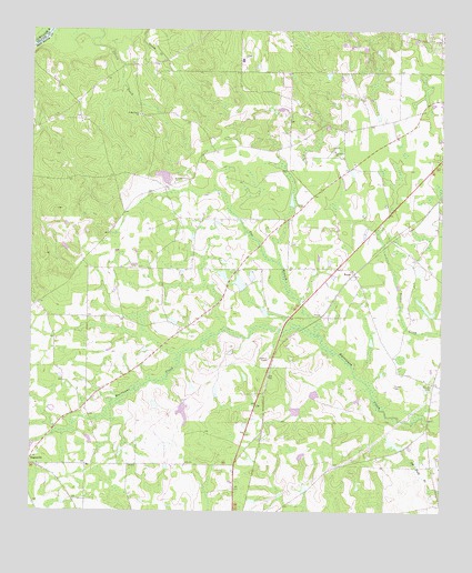
Roper, GA USGS Topographic Map
Click on map above to begin viewing in our Map Viewer.

This topographic map contains these locations and features:
Feature Name Type Latitude Longitude GNIS ID View Map
Denton DivisionCivilN31.7501°W82.7269°1936223View Map
Elbethel ChurchChurchN31.8527°W82.6324°335097View Map
Elizabeth ChurchChurchN31.8127°W82.6521°335099View Map
Elizabeth Church (historical)ChurchN31.7835°W82.6268°335098View Map
Fox BranchStreamN31.7980°W82.6629°355904View Map
Goldsmith (historical)Populated PlaceN31.7835°W82.6790°335102View Map
Harris and McDew CemeteryCemeteryN31.8521°W82.7143°335107View Map
Hearns Chapel (historical)ChurchN31.8205°W82.6999°335109View Map
Hinson CemeteryCemeteryN31.7830°W82.6275°315454View Map
Hinson CemeteryCemeteryN31.7829°W82.6390°315455View Map
Jeff Davis CountyCivilN31.8056°W82.6369°1687999View Map
Kingdom Hall ChurchChurchN31.8749°W82.6376°335117View Map
Kirkland Grove ChurchChurchN31.8352°W82.7060°316476View Map
Oak Grove Baptist ChurchChurchN31.8438°W82.6576°319781View Map
Okuinn LakeReservoirN31.8115°W82.6822°342177View Map
Okuinn LakeReservoirN31.8093°W82.6862°341814View Map
Okuinn Lake DamDamN31.8102°W82.6815°342176View Map
Okuinn Lake DamDamN31.8085°W82.6865°341813View Map
RoperPopulated PlaceN31.8121°W82.6515°326499View Map
Saint Matthews ChurchChurchN31.8532°W82.7171°322218View Map
Sears LakeReservoirN31.8735°W82.6482°341816View Map
Sears Lake DamDamN31.8735°W82.6482°341815View Map

Note: Coordinates in the location and feature list above are referenced to NAD83 datum.


Copyright (C) 2008-2024 Ryan Niemi / Sunset Dynamics ... All Rights Reserved