TopoQuest Logo
Do you find TopoQuest useful?
Help keep TopoQuest running and adding new maps/features by donating!
Bitcoin:  19c7KJd3qBynnjoSw5npx9KScwjBe4ifkT
Litecoin:  LXs6TkuXGGXo1vDsWCkWVdjQX94eUKd6ui
Home View Maps Find Maps Find Places Resources & Links


Spirit Lake, Minnesota Topographic Map

USGS Map Title: Spirit Lake, MN
USGS Map MRC: 46093D6
DRG (GeoTIFF) Download: o46093d6.tif


Neighboring USGS Topographic Map Quads:


  Iron Hub, MN  
46093E7
 

  Aitkin, MN  
46093E6
 

  Hassman, MN  
46093E5
 

  Bay Lake, MN  
46093D7
 

  Spirit Lake, MN  
46093D6
 

  Glen, MN  
46093D5
 

  Garrison, MN  
46093C7
 

  Wealthwood, MN  
46093C6
 

  Malmo, MN  
46093C5


Map MRC Location:

N47°
W94°
N47°
W93°
H8 H7 H6 H5 H4 H3 H2 H1
G8 G7 G6 G5 G4 G3 G2 G1
F8 F7 F6 F5 F4 F3 F2 F1
E8 E7 E6 E5 E4 E3 E2 E1
D8 D7 D6 D5 D4 D3 D2 D1
C8 C7 C6 C5 C4 C3 C2 C1
B8 B7 B6 B5 B4 B3 B2 B1
A8 A7 A6 A5 A4 A3 A2 A1
N46°
W94°
N46°
W93°

Spirit Lake, MN USGS 1:24K Topographic Map Preview:
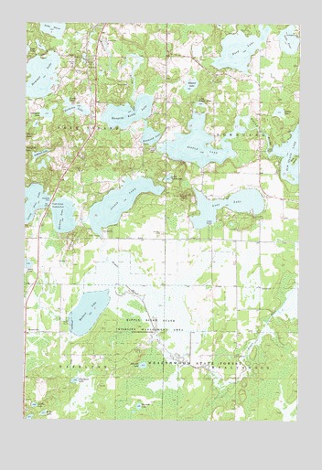
Spirit Lake, MN USGS Topographic Map
Click on map above to begin viewing in our Map Viewer.

This topographic map contains these locations and features:
Feature Name Type Latitude Longitude GNIS ID View Map
Anderson LakeLakeN46.4586°W93.7438°639344View Map
Apple LakeLakeN46.4240°W93.7487°639414View Map
Bachelor LakeLakeN46.4726°W93.7271°639547View Map
BennettvillePopulated PlaceN46.4019°W93.7489°639928View Map
Big K CampgroundLocaleN46.4367°W93.7431°2070747View Map
Constance LakeLakeN46.3878°W93.7260°641449View Map
Diamond LakeLakeN46.4644°W93.6931°642802View Map
Diamond Lake CemeteryCemeteryN46.4608°W93.6917°2070753View Map
Ditch Number ThirtyfourCanalN46.4030°W93.6416°642847View Map
Edquist LakeLakeN46.4806°W93.6747°643187View Map
Elm IslandIslandN46.4577°W93.6269°643300View Map
Elm Island LakeLakeN46.4592°W93.6257°643301View Map
Fire Tower HillSummitN46.4458°W93.6750°643645View Map
Hammal LakeLakeN46.4830°W93.7435°644607View Map
Hanging Kettle LakeLakeN46.4718°W93.7036°644625View Map
Hanging Kettle LakeReservoirN46.4766°W93.7002°1776322View Map
Hanging Kettle Lake DamDamN46.4766°W93.7002°1776321View Map
Hickory HillSummitN46.4325°W93.7266°644930View Map
Hickory LakeLakeN46.4392°W93.7324°644931View Map
Jacobs LakeLakeN46.3798°W93.7451°645570View Map
Johnson LakeLakeN46.3924°W93.6957°645695View Map
Kelly LakeLakeN46.3772°W93.7407°646078View Map
Lake FourLakeN46.4949°W93.6304°643847View Map
Lake ThreeLakeN46.4982°W93.7381°653184View Map
Landgren LakeLakeN46.4712°W93.7406°646466View Map
Little Pine LakeLakeN46.4433°W93.7461°646890View Map
Little Ripple LakeLakeN46.4746°W93.6704°646906View Map
Little Turtle LakeLakeN46.4513°W93.6848°646953View Map
Lone LakeLakeN46.4427°W93.6580°647011View Map
Mallard LakeLakeN46.4096°W93.7207°647404View Map
Maria ChapelChurchN46.4611°W93.6914°647521View Map
Nord LakeLakeN46.4918°W93.6527°648583View Map
Pine LakeReservoirN46.4416°W93.7386°1776318View Map
Pine Lake DamDamN46.4416°W93.7386°1776317View Map
Ripple LakeLakeN46.4618°W93.6718°650095View Map
Ripple Lake DamDamN46.4616°W93.6902°1776319View Map
Ripple River State Wildlife Management AreaParkN46.4052°W93.6919°650097View Map
Sixteen LakeLakeN46.4724°W93.6344°652103View Map
Spirit LakeLakeN46.4434°W93.7071°652399View Map
Sunset LakeLakeN46.4750°W93.7312°652855View Map
Thirteen LakeLakeN46.3795°W93.6974°653139View Map
Township of Farm IslandCivilN46.4610°W93.7486°664148View Map

Note: Coordinates in the location and feature list above are referenced to NAD83 datum.


Copyright (C) 2008-2024 Ryan Niemi / Sunset Dynamics ... All Rights Reserved