TopoQuest Logo
Do you find TopoQuest useful?
Help keep TopoQuest running and adding new maps/features by donating!
Bitcoin:  19c7KJd3qBynnjoSw5npx9KScwjBe4ifkT
Litecoin:  LXs6TkuXGGXo1vDsWCkWVdjQX94eUKd6ui
Home View Maps Find Maps Find Places Resources & Links


Glen, Minnesota Topographic Map

USGS Map Title: Glen, MN
USGS Map MRC: 46093D5
DRG (GeoTIFF) Download: o46093d5.tif


Neighboring USGS Topographic Map Quads:


  Aitkin, MN  
46093E6
 

  Hassman, MN  
46093E5
 

  Kimberly, MN  
46093E4
 

  Spirit Lake, MN  
46093D6
 

  Glen, MN  
46093D5
 

  Thor, MN  
46093D4
 

  Wealthwood, MN  
46093C6
 

  Malmo, MN  
46093C5
 

  Thor SW, MN  
46093C4


Map MRC Location:

N47°
W94°
N47°
W93°
H8 H7 H6 H5 H4 H3 H2 H1
G8 G7 G6 G5 G4 G3 G2 G1
F8 F7 F6 F5 F4 F3 F2 F1
E8 E7 E6 E5 E4 E3 E2 E1
D8 D7 D6 D5 D4 D3 D2 D1
C8 C7 C6 C5 C4 C3 C2 C1
B8 B7 B6 B5 B4 B3 B2 B1
A8 A7 A6 A5 A4 A3 A2 A1
N46°
W94°
N46°
W93°

Glen, MN USGS 1:24K Topographic Map Preview:
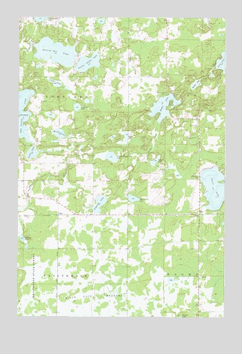
Glen, MN USGS Topographic Map
Click on map above to begin viewing in our Map Viewer.

This topographic map contains these locations and features:
Feature Name Type Latitude Longitude GNIS ID View Map
Bethlehem CemeteryCemeteryN46.4756°W93.6175°2070746View Map
Bethlehem ChurchChurchN46.4761°W93.6166°640058View Map
Calvary Baptist CemeteryCemeteryN46.4189°W93.6006°2070749View Map
Carrol Heft DamDamN46.4800°W93.6169°1776398View Map
Carrol Heft ReservoirReservoirN46.4800°W93.6169°1776399View Map
Clear LakeLakeN46.4293°W93.5039°641301View Map
Clear Lake Parish HouseChurchN46.4330°W93.5158°641305View Map
GlenPopulated PlaceN46.4186°W93.5152°644171View Map
Glen Lookout TowerTowerN46.4633°W93.5125°659840View Map
Glen Post Office (historical)Post OfficeN46.4186°W93.5150°2070765View Map
GloryPopulated PlaceN46.4175°W93.6005°654724View Map
Glory Baptist ChurchChurchN46.4183°W93.6006°2070970View Map
Glory Post Office (historical)Post OfficeN46.4175°W93.6003°2070766View Map
Johnson LakeLakeN46.4404°W93.5424°645698View Map
Killroy LakeLakeN46.4076°W93.6224°646143View Map
Linde LakeLakeN46.4727°W93.6029°646710View Map
Lingroth LakeLakeN46.4221°W93.5760°646723View Map
Mille Lacs MeadowsSwampN46.3838°W93.5766°647860View Map
Monson LakeLakeN46.4515°W93.6004°648040View Map
Rabbit LakeLakeN46.4628°W93.5375°649779View Map
Rabbit Lake CemeteryCemeteryN46.4686°W93.5363°649781View Map
Section Ten LakeLakeN46.4853°W93.6031°651833View Map
Section Twelve LakeLakeN46.4810°W93.5833°651836View Map
Section Twenty-Five LakeLakeN46.4418°W93.5689°651837View Map
Sjodin LakeLakeN46.4432°W93.6168°652106View Map
Spring LakeLakeN46.4724°W93.5174°652466View Map
Sweetman LakeLakeN46.4624°W93.5897°652941View Map
Thirty-One LakeLakeN46.4245°W93.5556°653143View Map
Township of NordlandCivilN46.4611°W93.6221°665134View Map
Turtle LakeLakeN46.4503°W93.5596°653380View Map
Valparaiso Post Office (historical)Post OfficeN46.4833°W93.5903°2071003View Map

Note: Coordinates in the location and feature list above are referenced to NAD83 datum.


Copyright (C) 2008-2024 Ryan Niemi / Sunset Dynamics ... All Rights Reserved