TopoQuest Logo
Do you find TopoQuest useful?
Help keep TopoQuest running and adding new maps/features by donating!
Bitcoin:  19c7KJd3qBynnjoSw5npx9KScwjBe4ifkT
Litecoin:  LXs6TkuXGGXo1vDsWCkWVdjQX94eUKd6ui
Home View Maps Find Maps Find Places Resources & Links


Spring Creek, Tennessee Topographic Map

USGS Map Title: Spring Creek, TN
USGS Map MRC: 35088G6
DRG (GeoTIFF) Download: o35088g6.tif


Neighboring USGS Topographic Map Quads:


  Milan, TN  
35088H7
 

  Atwood, TN  
35088H6
 

  McLemoresville, TN  
35088H5
 

  Medina, TN  
35088G7
 

  Spring Creek, TN  
35088G6
 

  Cedar Grove, TN  
35088G5
 

  Jackson North, TN  
35088F7
 

  Claybrook, TN  
35088F6
 

  Juno, TN  
35088F5


Map MRC Location:

N36°
W89°
N36°
W88°
H8 H7 H6 H5 H4 H3 H2 H1
G8 G7 G6 G5 G4 G3 G2 G1
F8 F7 F6 F5 F4 F3 F2 F1
E8 E7 E6 E5 E4 E3 E2 E1
D8 D7 D6 D5 D4 D3 D2 D1
C8 C7 C6 C5 C4 C3 C2 C1
B8 B7 B6 B5 B4 B3 B2 B1
A8 A7 A6 A5 A4 A3 A2 A1
N35°
W89°
N35°
W88°

Spring Creek, TN USGS 1:24K Topographic Map Preview:
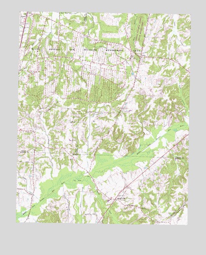
Spring Creek, TN USGS Topographic Map
Click on map above to begin viewing in our Map Viewer.

This topographic map contains these locations and features:
Feature Name Type Latitude Longitude GNIS ID View Map
Bellwood School (historical)SchoolN35.8248°W88.6701°1320306View Map
Birch BranchStreamN35.8087°W88.6287°1277488View Map
Crooked CreekStreamN35.7717°W88.7184°1281671View Map
District 1 (historical)CivilN35.8348°W88.7473°1310191View Map
District 1 (historical)CivilN35.8667°W88.6334°1325874View Map
Dry BranchStreamN35.7648°W88.7289°1282845View Map
Dry CreekStreamN35.7787°W88.7034°1282917View Map
Dry CreekStreamN35.8637°W88.7264°1282918View Map
Duffys CreekStreamN35.7617°W88.7334°1283080View Map
Elam CemeteryCemeteryN35.8678°W88.7145°1283589View Map
Gilmers CreekStreamN35.7748°W88.7020°1285426View Map
GraballPopulated PlaceN35.8726°W88.7448°1285769View Map
Hope Hill CemeteryCemeteryN35.8217°W88.7223°1288281View Map
Hope Hill Church (historical)ChurchN35.8226°W88.7231°1322123View Map
Hope Hill School (historical)SchoolN35.8195°W88.7223°1322124View Map
Hopewell CemeteryCemeteryN35.8037°W88.7406°1288296View Map
Hopewell Church (historical)ChurchN35.8040°W88.7401°1322125View Map
Lake Site Number 86-2ReservoirN35.8567°W88.6517°1302176View Map
Latham ChapelChurchN35.8103°W88.7098°1290669View Map
LaviniaPopulated PlaceN35.8492°W88.6609°1290773View Map
Lavinia Baptist ChurchChurchN35.8495°W88.6551°1326887View Map
Lavinia CemeteryCemeteryN35.8481°W88.6617°1326664View Map
Lavinia Methodist ChurchChurchN35.8478°W88.6617°1326665View Map
Lavinia Post OfficePost OfficeN35.8523°W88.6599°1651413View Map
Madison County Fire Department Station 7BuildingN35.7646°W88.6817°2654026View Map
New Carmel ChurchChurchN35.7595°W88.6587°1295454View Map
OFDBA Number 86-2 DamDamN35.8567°W88.6517°1302177View Map
Old River RunStreamN35.7753°W88.7126°1269841View Map
Spring CreekPopulated PlaceN35.7667°W88.6773°1271065View Map
Spring CreekStreamN35.7756°W88.7012°1271091View Map
Spring Creek Baptist ChurchChurchN35.7648°W88.6817°1321070View Map
Spring Creek Post OfficePost OfficeN35.7641°W88.6788°1651649View Map
Spring Creek School (historical)SchoolN35.7648°W88.6812°1321071View Map
Strayhorn School (historical)SchoolN35.8678°W88.6817°1320372View Map
Sunset View ChurchChurchN35.7670°W88.6759°1271887View Map
West Carroll Primary SchoolSchoolN35.8462°W88.6617°1323600View Map
West Plains ChurchChurchN35.8651°W88.7467°1304483View Map

Note: Coordinates in the location and feature list above are referenced to NAD83 datum.


Copyright (C) 2008-2024 Ryan Niemi / Sunset Dynamics ... All Rights Reserved