TopoQuest Logo
Do you find TopoQuest useful?
Help keep TopoQuest running and adding new maps/features by donating!
Bitcoin:  19c7KJd3qBynnjoSw5npx9KScwjBe4ifkT
Litecoin:  LXs6TkuXGGXo1vDsWCkWVdjQX94eUKd6ui
Home View Maps Find Maps Find Places Resources & Links


Cedar Grove, Tennessee Topographic Map

USGS Map Title: Cedar Grove, TN
USGS Map MRC: 35088G5
DRG (GeoTIFF) Download: o35088g5.tif


Neighboring USGS Topographic Map Quads:


  Atwood, TN  
35088H6
 

  McLemoresville, TN  
35088H5
 

  Palmer Shelter, TN  
35088H4
 

  Spring Creek, TN  
35088G6
 

  Cedar Grove, TN  
35088G5
 

  Clarksburg, TN  
35088G4
 

  Claybrook, TN  
35088F6
 

  Juno, TN  
35088F5
 

  Lexington, TN  
35088F4


Map MRC Location:

N36°
W89°
N36°
W88°
H8 H7 H6 H5 H4 H3 H2 H1
G8 G7 G6 G5 G4 G3 G2 G1
F8 F7 F6 F5 F4 F3 F2 F1
E8 E7 E6 E5 E4 E3 E2 E1
D8 D7 D6 D5 D4 D3 D2 D1
C8 C7 C6 C5 C4 C3 C2 C1
B8 B7 B6 B5 B4 B3 B2 B1
A8 A7 A6 A5 A4 A3 A2 A1
N35°
W89°
N35°
W88°

Cedar Grove, TN USGS 1:24K Topographic Map Preview:
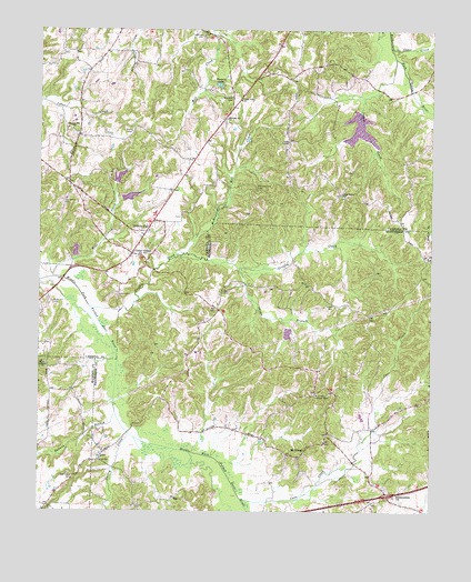
Cedar Grove, TN USGS Topographic Map
Click on map above to begin viewing in our Map Viewer.

This topographic map contains these locations and features:
Feature Name Type Latitude Longitude GNIS ID View Map
Cane CreekStreamN35.7534°W88.5603°1305660View Map
Cane CreekStreamN35.8706°W88.5137°1279517View Map
Carroll County Rural Fire Department District 5 Cedar GroveBuildingN35.8247°W88.5899°2654153View Map
Cedar GrovePopulated PlaceN35.8170°W88.5956°1305763View Map
Cedar Grove ChurchChurchN35.8567°W88.5617°1280045View Map
Cedar Grove Division (historical)CensusN35.8595°W88.5970°1648627View Map
Cedar Grove Post OfficePost OfficeN35.8162°W88.5958°1651404View Map
Cedar Grove School (historical)SchoolN35.8587°W88.5692°1320317View Map
Christ TempleChurchN35.8462°W88.5462°1280517View Map
Clark School (historical)SchoolN35.8637°W88.6103°1320319View Map
District 6 (historical)CivilN35.8501°W88.5751°1325879View Map
Duncans Store (historical)LocaleN35.8576°W88.5637°1320323View Map
Eubank BranchStreamN35.7756°W88.6003°1283875View Map
Furgerson CemeteryCemeteryN35.8734°W88.5739°1285040View Map
Griffin CreekStreamN35.8031°W88.6089°1286269View Map
Gurley CreekStreamN35.7701°W88.5962°1286453View Map
Hickory FlatPopulated PlaceN35.8228°W88.5912°1287573View Map
Hickory Flat ChurchChurchN35.8226°W88.5901°1320327View Map
Hoopers LakeReservoirN35.8606°W88.5681°1288255View Map
Indian CreekStreamN35.8681°W88.5120°1288944View Map
Indian Creek Lake Number 87-1ReservoirN35.8551°W88.5234°1302174View Map
Indian Creek Number 87-1 DamDamN35.8551°W88.5234°1302175View Map
Interchange 101CrossingN35.7545°W88.5137°1310813View Map
LawPopulated PlaceN35.7631°W88.6053°1290774View Map
Lebanon ChurchChurchN35.7881°W88.6231°1306673View Map
McHaney (historical)Populated PlaceN35.8117°W88.5867°1310815View Map
McHayneys Mill (historical)LocaleN35.8128°W88.5884°1320346View Map
McHayneys Mill CreekStreamN35.8173°W88.5784°1306735View Map
Morning Sun CemeteryCemeteryN35.8337°W88.5564°1294397View Map
Morning Sun ChurchChurchN35.8520°W88.5659°1294398View Map
Moss CreekStreamN35.8109°W88.6209°1294500View Map
Moss Creek LakeReservoirN35.8301°W88.6001°1302162View Map
Moss Creek OFDBA 87-4 DamDamN35.8301°W88.6001°1302163View Map
Moss RestLocaleN35.8023°W88.5681°1317495View Map
Mount GileadPopulated PlaceN35.7659°W88.5398°1294612View Map
Mount Gilead Baptist ChurchChurchN35.7706°W88.5328°1317497View Map
Mount Gilead Lookout TowerTowerN35.7803°W88.5367°1647784View Map
Munt Gilead School (historical)SchoolN35.7701°W88.5337°1317498View Map
New Bethel Baptist ChurchChurchN35.8323°W88.5287°1326841View Map
Oak Grove CemeteryCemeteryN35.7581°W88.6139°1296072View Map
OFDBA 87-3 DamDamN35.8351°W88.6001°1302167View Map
OFDBA 87-3 LakeReservoirN35.8368°W88.6000°1302166View Map
Pleasant Hill CemeteryCemeteryN35.8481°W88.6148°1326679View Map
Pleasant Hill CemeteryCemeteryN35.7601°W88.5409°1317507View Map
Pleasant Hill ChurchChurchN35.8492°W88.6148°1326853View Map
Providence CemeteryCemeteryN35.8306°W88.6175°1298600View Map
SharonPopulated PlaceN35.7556°W88.5142°1310827View Map
Sharon Church (historical)ChurchN35.7570°W88.5139°1317531View Map
SmithPopulated PlaceN35.8092°W88.5398°1310828View Map
Spain (historical)Populated PlaceN35.8048°W88.5106°1310831View Map
Spain CemeteryCemeteryN35.8070°W88.5664°1270941View Map
Stanford FarmsLocaleN35.7617°W88.5419°2611166View Map
Susan BranchStreamN35.8134°W88.5617°1271891View Map
Susan Branch 87-7 DamDamN35.7984°W88.5467°1302141View Map
Susan Branch LakeReservoirN35.7984°W88.5467°1307157View Map
Utley (historical)Populated PlaceN35.7692°W88.5537°1310835View Map
Wood Hill CemeteryCemeteryN35.8042°W88.6209°1275020View Map
Woodard CemeteryCemeteryN35.8576°W88.5642°1275027View Map
Woodhill (historical)Populated PlaceN35.8065°W88.6223°1311772View Map

Note: Coordinates in the location and feature list above are referenced to NAD83 datum.


Copyright (C) 2008-2024 Ryan Niemi / Sunset Dynamics ... All Rights Reserved