TopoQuest Logo
Do you find TopoQuest useful?
Help keep TopoQuest running and adding new maps/features by donating!
Bitcoin:  19c7KJd3qBynnjoSw5npx9KScwjBe4ifkT
Litecoin:  LXs6TkuXGGXo1vDsWCkWVdjQX94eUKd6ui
Home View Maps Find Maps Find Places Resources & Links


Superior, Iowa Topographic Map

USGS Map Title: Superior, IA
USGS Map MRC: 43094D8
DRG (GeoTIFF) Download: o43094d8.tif


Neighboring USGS Topographic Map Quads:


  Lakefield SE, MN  
43095E1
 

  Jackson, MN  
43094E8
 

  Dunnell, MN  
43094E7
 

  Spirit Lake, IA  
43095D1
 

  Superior, IA  
43094D8
 

  Estherville, IA  
43094D7
 

  Spirit Lake SE, IA  
43095C1
 

  Terril, IA  
43094C8
 

  Wallingford, IA  
43094C7


Map MRC Location:

N44°
W95°
N44°
W94°
H8 H7 H6 H5 H4 H3 H2 H1
G8 G7 G6 G5 G4 G3 G2 G1
F8 F7 F6 F5 F4 F3 F2 F1
E8 E7 E6 E5 E4 E3 E2 E1
D8 D7 D6 D5 D4 D3 D2 D1
C8 C7 C6 C5 C4 C3 C2 C1
B8 B7 B6 B5 B4 B3 B2 B1
A8 A7 A6 A5 A4 A3 A2 A1
N43°
W95°
N43°
W94°

Superior, IA USGS 1:24K Topographic Map Preview:
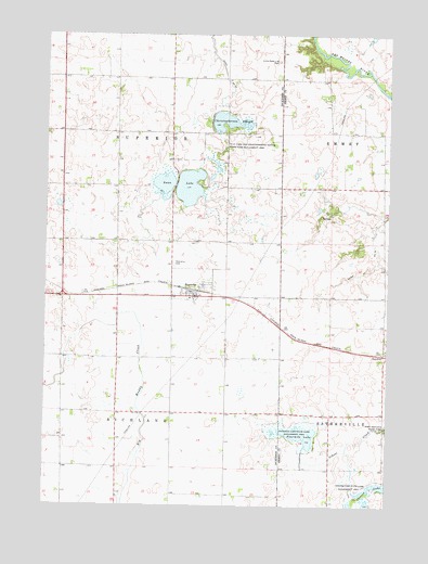
Superior, IA USGS Topographic Map
Click on map above to begin viewing in our Map Viewer.

This topographic map contains these locations and features:
Feature Name Type Latitude Longitude GNIS ID View Map
Carr FarmLocaleN43.4147°W94.8877°2729832View Map
Christopherson SloughGutN43.4772°W94.9364°455409View Map
Christopherson Slough / Little Swan Lake Wildlife Management AreaParkN43.4683°W94.9394°462135View Map
City of SuperiorCivilN43.4337°W94.9467°2396008View Map
Ditch Number 23CanalN43.4886°W94.9355°465700View Map
Ditch Number 79CanalN43.4452°W94.8811°465744View Map
Farmers Elevator Company ElevatorLocaleN43.4302°W94.9464°1907669View Map
Four Mile Lake Wildlife Management AreaParkN43.3944°W94.9086°1907403View Map
Fourmile LakeReservoirN43.3939°W94.9068°456711View Map
Heebner FarmsLocaleN43.4858°W94.9764°2726795View Map
SuperiorPopulated PlaceN43.4302°W94.9464°462121View Map
SuperiorLocaleN43.4319°W94.9475°1907670View Map
Superior Fire DepartmentBuildingN43.4316°W94.9480°2577409View Map
Superior Marsh AreaParkN43.4611°W94.9169°1907742View Map
Superior Post OfficePost OfficeN43.4312°W94.9480°1907668View Map
Superior Public LibraryBuildingN43.4302°W94.9464°1907667View Map
Superior Township CemeteryCemeteryN43.4392°W94.9537°463349View Map
Swan LakeLakeN43.4594°W94.9479°462133View Map
Township of RichlandCivilN43.3862°W94.9732°468603View Map
Township of SuperiorCivilN43.4657°W94.9736°468770View Map
Union State Line CemeteryCemeteryN43.4930°W94.9157°462473View Map

Note: Coordinates in the location and feature list above are referenced to NAD83 datum.


Copyright (C) 2008-2024 Ryan Niemi / Sunset Dynamics ... All Rights Reserved