TopoQuest Logo
Do you find TopoQuest useful?
Help keep TopoQuest running and adding new maps/features by donating!
Bitcoin:  19c7KJd3qBynnjoSw5npx9KScwjBe4ifkT
Litecoin:  LXs6TkuXGGXo1vDsWCkWVdjQX94eUKd6ui
Home View Maps Find Maps Find Places Resources & Links


Theodore Roosevelt Dam, Arizona Topographic Map

USGS Map Title: Theodore Roosevelt Dam, AZ
USGS Map MRC: 33111F2
DRG (GeoTIFF) Download: o33111f2.tif


Neighboring USGS Topographic Map Quads:


  Tonto Basin, AZ  
33111G3
 

  Greenback Creek, AZ  
33111G2
 

  Armer Mountain, AZ  
33111G1
 

  Four Peaks, AZ  
33111F3
 

  Theodore Roosevelt Dam, AZ  
33111F2
 

  Windy Hill, AZ  
33111F1
 

  Horse Mesa Dam, AZ  
33111E3
 

  Pinyon Mountain, AZ  
33111E2
 

  Two Bar Mountain, AZ  
33111E1


Map MRC Location:

N34°
W112°
N34°
W111°
H8 H7 H6 H5 H4 H3 H2 H1
G8 G7 G6 G5 G4 G3 G2 G1
F8 F7 F6 F5 F4 F3 F2 F1
E8 E7 E6 E5 E4 E3 E2 E1
D8 D7 D6 D5 D4 D3 D2 D1
C8 C7 C6 C5 C4 C3 C2 C1
B8 B7 B6 B5 B4 B3 B2 B1
A8 A7 A6 A5 A4 A3 A2 A1
N33°
W112°
N33°
W111°

Theodore Roosevelt Dam, AZ USGS 1:24K Topographic Map Preview:
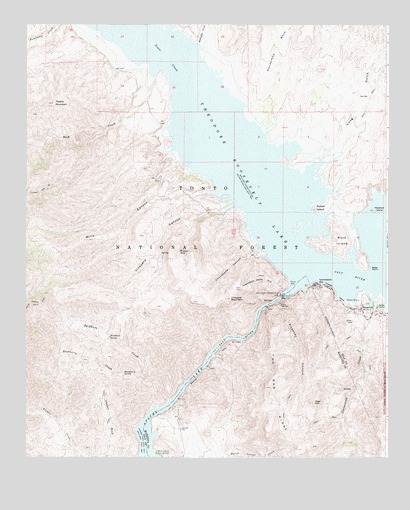
Theodore Roosevelt Dam, AZ USGS Topographic Map
Click on map above to begin viewing in our Map Viewer.

This topographic map contains these locations and features:
Feature Name Type Latitude Longitude GNIS ID View Map
Alchesay CanyonValleyN33.6700°W111.1634°25566View Map
Apache Lake Boat LaunchLocaleN33.6250°W111.2037°2669712View Map
Apacheria (historical)LocaleN33.6764°W111.1507°45648View Map
Bachelor Cove AreaBayN33.7100°W111.1948°39241View Map
Bachelor Cove Recreation SiteLocaleN33.7139°W111.2046°40906View Map
Bass PointCapeN33.6795°W111.1318°26026View Map
Bermuda Flat Recreation SiteLocaleN33.7456°W111.2262°40909View Map
Buckhorn BasinBasinN33.6623°W111.2273°42758View Map
Buckhorn CreekStreamN33.6420°W111.2015°26912View Map
Buckhorn SpringSpringN33.6598°W111.2209°26922View Map
Buckhorn TankReservoirN33.6409°W111.1568°40810View Map
Burnt Corral Recreation SiteLocaleN33.6264°W111.2048°27023View Map
Canyon SpringSpringN33.6778°W111.2123°39322View Map
Cholla Bay AreaBayN33.7189°W111.2001°39348View Map
Cholla Bay Boating SiteLocaleN33.7198°W111.2021°40912View Map
Cholla Bay Recreation SiteLocaleN33.7184°W111.2040°40910View Map
Cholla CampgroundLocaleN33.7294°W111.2048°2670544View Map
Cholla Recreation SiteLocaleN33.7278°W111.2048°2060451View Map
Chuckwalla CanyonValleyN33.6858°W111.1693°27625View Map
Cottonwood Cove Picnic AreaLocaleN33.6685°W111.1290°2669523View Map
Cottonwood CreekStreamN33.6659°W111.1321°28013View Map
Coyote TankReservoirN33.6456°W111.1630°40811View Map
Deer HillSummitN33.6410°W111.1505°28379View Map
Deer Hill TankReservoirN33.6391°W111.1617°40809View Map
Fools PassChannelN33.6948°W111.1371°40907View Map
Fox Gulch Sycamore CreekStreamN33.7300°W111.2079°33700View Map
Gila County Sheriff's Office Roosevelt SubstationBuildingN33.6696°W111.1415°2751679View Map
Goose FlatsFlatN33.7317°W111.1743°40911View Map
Government HillPopulated PlaceN33.6745°W111.1501°29439View Map
Granite Spring TrailTrailN33.6717°W111.2429°29496View Map
Hackberry CreekStreamN33.6470°W111.2096°29663View Map
Hackberry SpringSpringN33.6487°W111.2162°29671View Map
Haystack IslandIslandN33.6964°W111.1298°29813View Map
Hillside SpringSpringN33.6259°W111.1518°40905View Map
Horse Pasture Recreation AreaParkN33.7448°W111.2273°39520View Map
Hotel PointCapeN33.6778°W111.1596°39525View Map
Inspiration PointCliffN33.6756°W111.1696°30395View Map
Lake TankReservoirN33.7356°W111.1412°22347View Map
Lakeview Trailer ParkPopulated PlaceN33.6648°W111.1343°40813View Map
Little Salt River Valley (historical)ValleyN33.6778°W111.1437°42769View Map
Long GulchValleyN33.7104°W111.1477°31239View Map
Long Gulch SpringSpringN33.7294°W111.1315°39575View Map
Methodist CreekStreamN33.7445°W111.1901°31775View Map
Mills CanyonValleyN33.7017°W111.1825°31893View Map
Mills CoveBayN33.6950°W111.1737°2060452View Map
Mills Cove AreaBayN33.6945°W111.1737°39631View Map
Mills Ridge TankReservoirN33.6858°W111.2091°22353View Map
Mills Ridge TrailheadLocaleN33.6717°W111.2423°2060453View Map
Peters MountainSummitN33.7272°W111.2404°32823View Map
Pico Derecho MountainSummitN33.6834°W111.1340°45663View Map
Rabbit IslandIslandN33.6970°W111.1476°33304View Map
Rock CreekStreamN33.7303°W111.2079°41884View Map
Rock IslandIslandN33.6878°W111.1410°33719View Map
RooseveltPopulated PlaceN33.6675°W111.1343°33788View Map
Roosevelt Census Designated PlaceCensusN33.6619°W111.1295°2582854View Map
Roosevelt Dam HeliportAirportN33.6703°W111.1623°45487View Map
Roosevelt Lake Wildlife AreaParkN33.7389°W111.1910°39758View Map
Roosevelt MarinaLocaleN33.6717°W111.1368°40812View Map
Salt River Project HousingLocaleN33.6742°W111.1496°40908View Map
Soltera CoveBayN33.7106°W111.1985°40775View Map
South Cactus TankReservoirN33.7487°W111.1465°22371View Map
Squaw FlatFlatN33.6312°W111.2007°37080View Map
Sweetheart PeakSummitN33.6320°W111.1876°40808View Map
Theodore Roosevelt DamDamN33.6717°W111.1612°42945View Map
Thompson SpringSpringN33.6548°W111.1340°22376View Map
Three Bar Wildlife EnclosureParkN33.7028°W111.2276°40846View Map
Tonto Basin Ranger District OfficeLocaleN33.6703°W111.1329°39759View Map
Tonto CreekStreamN33.6800°W111.1515°35375View Map
Tuakay Hot SpringsSpringN33.6706°W111.1662°45687View Map
Vineyard CanyonValleyN33.6985°W111.1764°35786View Map
Vineyard Canyon Picnic AreaLocaleN33.6960°W111.1791°2669533View Map
Vineyard MountainSummitN33.6709°W111.1793°39864View Map
Vineyard SpringSpringN33.6802°W111.2042°39865View Map
Wildcat SeepSpringN33.6851°W111.1965°36187View Map

Note: Coordinates in the location and feature list above are referenced to NAD83 datum.


Copyright (C) 2008-2024 Ryan Niemi / Sunset Dynamics ... All Rights Reserved