TopoQuest Logo
Do you find TopoQuest useful?
Help keep TopoQuest running and adding new maps/features by donating!
Bitcoin:  19c7KJd3qBynnjoSw5npx9KScwjBe4ifkT
Litecoin:  LXs6TkuXGGXo1vDsWCkWVdjQX94eUKd6ui
Home View Maps Find Maps Find Places Resources & Links


Two Bar Mountain, Arizona Topographic Map

USGS Map Title: Two Bar Mountain, AZ
USGS Map MRC: 33111E1
DRG (GeoTIFF) Download: o33111e1.tif


Neighboring USGS Topographic Map Quads:


  Theodore Roosevelt Dam, AZ  
33111F2
 

  Windy Hill, AZ  
33111F1
 

  Meddler Wash, AZ  
33110F8
 

  Pinyon Mountain, AZ  
33111E2
 

  Two Bar Mountain, AZ  
33111E1
 

  Salt River Peak, AZ  
33110E8
 

  Iron Mountain, AZ  
33111D2
 

  Haunted Canyon, AZ  
33111D1
 

  Inspiration, AZ  
33110D8


Map MRC Location:

N34°
W112°
N34°
W111°
H8 H7 H6 H5 H4 H3 H2 H1
G8 G7 G6 G5 G4 G3 G2 G1
F8 F7 F6 F5 F4 F3 F2 F1
E8 E7 E6 E5 E4 E3 E2 E1
D8 D7 D6 D5 D4 D3 D2 D1
C8 C7 C6 C5 C4 C3 C2 C1
B8 B7 B6 B5 B4 B3 B2 B1
A8 A7 A6 A5 A4 A3 A2 A1
N33°
W112°
N33°
W111°

Two Bar Mountain, AZ USGS 1:24K Topographic Map Preview:
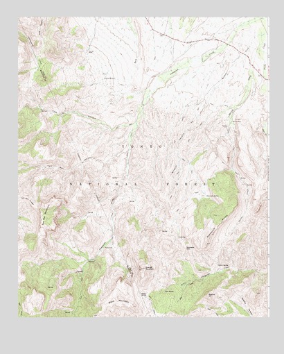
Two Bar Mountain, AZ USGS Topographic Map
Click on map above to begin viewing in our Map Viewer.

This topographic map contains these locations and features:
Feature Name Type Latitude Longitude GNIS ID View Map
Apache HillSummitN33.5095°W111.0304°25701View Map
Black Brush RanchLocaleN33.6103°W111.0904°2057429View Map
Black MountainSummitN33.5048°W111.0679°26418View Map
Blackberry SpringSpringN33.5481°W111.0673°39272View Map
Bobcat Tank Number TwoReservoirN33.5873°W111.0254°39279View Map
Brushy Basin SpringSpringN33.5773°W111.1132°36936View Map
Bull Canyon SpringSpringN33.5435°W111.0903°36939View Map
Campaign CreekStreamN33.6245°W111.0015°27220View Map
Campaign WellWellN33.6087°W111.0301°39318View Map
Cane SpringSpringN33.5442°W111.0561°39319View Map
Cedar SpringSpringN33.5217°W111.0253°27435View Map
Centipede SpringSpringN33.5695°W111.0910°39334View Map
Charlie TankReservoirN33.5676°W111.0259°39340View Map
Cholla TankReservoirN33.6105°W111.0420°39350View Map
Cottonwood SpringSpringN33.6173°W111.1221°36961View Map
Cross P RanchLocaleN33.5906°W111.0637°39391View Map
Double Corral TroughWellN33.5850°W111.1018°39416View Map
East TankReservoirN33.5853°W111.0365°39432View Map
Gans Hole SpringSpringN33.5580°W111.0144°39444View Map
Granite MountainSummitN33.5203°W111.0618°29480View Map
Granite TankReservoirN33.5642°W111.0393°39471View Map
Gunsight GapGapN33.5287°W111.0415°29632View Map
Hackberry SpringSpringN33.5567°W111.0865°39486View Map
Henderson TankReservoirN33.5918°W111.0539°39500View Map
Horrell RanchLocaleN33.5814°W111.0182°30120View Map
Horrell SpringSpringN33.5583°W111.0755°39515View Map
Lily Hole SpringSpringN33.5101°W111.0715°37017View Map
Lower H N TroughReservoirN33.5814°W111.0657°39583View Map
Monkey SpringSpringN33.5139°W111.1187°37039View Map
Mud SpringSpringN33.5112°W111.0521°32103View Map
Nonesuch RocksRidgeN33.5389°W111.0246°32343View Map
Nonesuch SpringSpringN33.5501°W111.0313°32344View Map
Reavis GapGapN33.5209°W111.1243°37064View Map
Roosevelt Lake EstatesPopulated PlaceN33.6223°W111.0035°2045569View Map
Roosevelt Post OfficePost OfficeN33.6011°W111.0060°2783324View Map
Schoolhouse TankReservoirN33.6012°W111.0811°39781View Map
Spring CreekStreamN33.6137°W111.0026°34724View Map
Spring Creek RanchLocaleN33.5817°W111.0187°42670View Map
Substitute TankReservoirN33.6109°W111.0571°39818View Map
Swede SpringSpringN33.5264°W111.0579°39823View Map
Tonto Basin Fire District Station 6BuildingN33.6026°W111.0056°2672704View Map
Top TankReservoirN33.6170°W111.1135°39839View Map
Tule CanyonValleyN33.5812°W111.0660°35501View Map
Tule SpringSpringN33.5861°W111.1099°37104View Map
Tule TankReservoirN33.5956°W111.1207°37105View Map
Two Bar CanyonValleyN33.5703°W111.0696°35637View Map
Two Bar MountainSummitN33.5373°W111.1137°35638View Map
Two Bar RanchLocaleN33.6109°W111.0904°35639View Map
Upper HorrellLocaleN33.5287°W111.0832°42671View Map
Upper Two Bar SpringSpringN33.5612°W111.1248°37111View Map
Wildcat CanyonValleyN33.5959°W111.0251°36175View Map
Willow SpringSpringN33.5087°W111.0610°36243View Map

Note: Coordinates in the location and feature list above are referenced to NAD83 datum.


Copyright (C) 2008-2024 Ryan Niemi / Sunset Dynamics ... All Rights Reserved