TopoQuest Logo
Do you find TopoQuest useful?
Help keep TopoQuest running and adding new maps/features by donating!
Bitcoin:  19c7KJd3qBynnjoSw5npx9KScwjBe4ifkT
Litecoin:  LXs6TkuXGGXo1vDsWCkWVdjQX94eUKd6ui
Home View Maps Find Maps Find Places Resources & Links


Three Lakes, Wisconsin Topographic Map

USGS Map Title: Three Lakes, WI
USGS Map MRC: 45089G2
DRG (GeoTIFF) Download: o45089g2.tif


Neighboring USGS Topographic Map Quads:


  Eagle River West, WI  
45089H3
 

  Eagle River East, WI  
45089H2
 

  Anvil Lake, WI  
45089H1
 

  Sugar Camp, WI  
45089G3
 

  Three Lakes, WI  
45089G2
 

  Julia Lake, WI  
45089G1
 

  Moen Lake, WI  
45089F3
 

  Starks, WI  
45089F2
 

  Monico NE, WI  
45089F1


Map MRC Location:

N46°
W90°
N46°
W89°
H8 H7 H6 H5 H4 H3 H2 H1
G8 G7 G6 G5 G4 G3 G2 G1
F8 F7 F6 F5 F4 F3 F2 F1
E8 E7 E6 E5 E4 E3 E2 E1
D8 D7 D6 D5 D4 D3 D2 D1
C8 C7 C6 C5 C4 C3 C2 C1
B8 B7 B6 B5 B4 B3 B2 B1
A8 A7 A6 A5 A4 A3 A2 A1
N45°
W90°
N45°
W89°

Three Lakes, WI USGS 1:24K Topographic Map Preview:
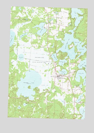
Three Lakes, WI USGS Topographic Map
Click on map above to begin viewing in our Map Viewer.

This topographic map contains these locations and features:
Feature Name Type Latitude Longitude GNIS ID View Map
Briard LakeLakeN45.8318°W89.1799°1562183View Map
Burnham CreekStreamN45.8169°W89.2354°1562434View Map
Clearwater LakeLakeN45.8505°W89.2002°1563170View Map
Clearwater LakePopulated PlaceN45.8536°W89.1882°1563171View Map
Cook LakeLakeN45.7614°W89.2318°1563340View Map
Green Bass LakeLakeN45.8567°W89.1538°1565798View Map
Hutchinson LakeLakeN45.7650°W89.2227°1566837View Map
Island LakeLakeN45.8290°W89.1332°1567014View Map
Korth LakeLakeN45.8610°W89.1839°1567621View Map
Little Moccasin LakeLakeN45.7874°W89.1329°1568322View Map
Long LakeLakeN45.8687°W89.1433°1579745View Map
Maple LakeLakeN45.8028°W89.1622°1568989View Map
Maple Lake 1ReservoirN45.8066°W89.1635°1792199View Map
Maple Lake 2WP487 DamDamN45.8066°W89.1635°1792198View Map
Medicine LakeLakeN45.8141°W89.1268°1579856View Map
Moccasin LakeLakeN45.7923°W89.1261°1579895View Map
Mosquito CreekStreamN45.8586°W89.2182°1569777View Map
Mud LakeLakeN45.7737°W89.1340°1569968View Map
One Stone LakeLakeN45.8423°W89.2290°1570825View Map
Oneida County Ambulance Three Lakes UnitBuildingN45.7991°W89.1791°2698332View Map
Planting Ground LakeLakeN45.8237°W89.1485°1571587View Map
Range Line LakeLakeN45.8190°W89.1767°1572073View Map
Rice CreekStreamN45.8341°W89.2426°1572249View Map
Rice LakeLakeN45.8180°W89.2311°1572265View Map
Rice Lake State Natural AreaParkN45.8186°W89.2317°2095668View Map
Round LakeLakeN45.8368°W89.1415°1572666View Map
Sampson Cranberry MarshLocaleN45.7867°W89.1933°2723765View Map
Seventh Day Adventist ChurchChurchN45.8577°W89.1874°1833726View Map
Spirit LakeLakeN45.7997°W89.1343°1574557View Map
Squash LakeLakeN45.8692°W89.1757°1574750View Map
Three LakesPopulated PlaceN45.7983°W89.1629°1575410View Map
Three Lakes Census Designated PlaceCensusN45.8047°W89.1708°2586558View Map
Three Lakes Elementary SchoolSchoolN45.7947°W89.1671°2713357View Map
Three Lakes High SchoolSchoolN45.7947°W89.1671°1843915View Map
Three Lakes Police DepartmentBuildingN45.7966°W89.1694°2759710View Map
Three Lakes Post OfficePost OfficeN45.7972°W89.1689°2723766View Map
Three Lakes Volunteer Fire DepartmentBuildingN45.7992°W89.1792°2696743View Map
Thunder LakeLakeN45.7878°W89.2168°1575427View Map
Thunder Lake State Wildlife AreaParkN45.8155°W89.2010°1575430View Map
Town of Three LakesCivilN45.8061°W89.1373°1584277View Map
Townline CreekStreamN45.8113°W89.1701°1575545View Map
Townline LakeLakeN45.8134°W89.1639°1575550View Map
WXPR-FM (Rhinelander)TowerN45.7744°W89.2485°1582625View Map

Note: Coordinates in the location and feature list above are referenced to NAD83 datum.


Copyright (C) 2008-2024 Ryan Niemi / Sunset Dynamics ... All Rights Reserved