TopoQuest Logo
Do you find TopoQuest useful?
Help keep TopoQuest running and adding new maps/features by donating!
Bitcoin:  19c7KJd3qBynnjoSw5npx9KScwjBe4ifkT
Litecoin:  LXs6TkuXGGXo1vDsWCkWVdjQX94eUKd6ui
Home View Maps Find Maps Find Places Resources & Links


Trees, Louisiana Topographic Map

USGS Map Title: Trees, LA
USGS Map MRC: 32094G1
DRG (GeoTIFF) Download: o32094g1.tif


Neighboring USGS Topographic Map Quads:


  Kildare, TX  
32094H2
 

  McLeod, TX  
32094H1
 

  Vivian North, LA  
32093H8
 

  Smithland, TX  
32094G2
 

  Trees, LA  
32094G1
 

  Vivian South, LA  
32093G8
 

  Karnack, TX  
32094F2
 

  Potters Point, TX  
32094F1
 

  Mooringsport, LA  
32093F8


Map MRC Location:

N33°
W95°
N33°
W94°
H8 H7 H6 H5 H4 H3 H2 H1
G8 G7 G6 G5 G4 G3 G2 G1
F8 F7 F6 F5 F4 F3 F2 F1
E8 E7 E6 E5 E4 E3 E2 E1
D8 D7 D6 D5 D4 D3 D2 D1
C8 C7 C6 C5 C4 C3 C2 C1
B8 B7 B6 B5 B4 B3 B2 B1
A8 A7 A6 A5 A4 A3 A2 A1
N32°
W95°
N32°
W94°

Trees, LA USGS 1:24K Topographic Map Preview:
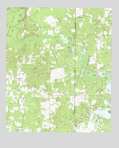
Trees, LA USGS Topographic Map
Click on map above to begin viewing in our Map Viewer.

This topographic map contains these locations and features:
Feature Name Type Latitude Longitude GNIS ID View Map
Bethlehem ChurchChurchN32.8135°W94.0913°1330533View Map
Bonham LandingPopulated PlaceN32.7557°W94.0371°543008View Map
Burks-Hart CemeteryCemeteryN32.8074°W94.0441°1331682View Map
Caddo Station (historical)LocaleN32.7904°W94.0099°552242View Map
Core CemeteryCemeteryN32.7957°W94.0907°1333352View Map
Core CemeteryCemeteryN32.7968°W94.0971°1333353View Map
Dixon PondLakeN32.8402°W94.0493°1334416View Map
Frazier CreekStreamN32.8729°W94.1230°1373771View Map
GethsemanePopulated PlaceN32.8026°W94.1094°1336504View Map
GrayPopulated PlaceN32.7876°W94.0735°1378378View Map
Gray CemeteryCemeteryN32.7801°W94.0694°1336879View Map
Harold CreekStreamN32.8107°W94.0105°554666View Map
Harts Ferry BridgeBridgeN32.8063°W94.0160°535549View Map
Hunts CreekStreamN32.8485°W94.0527°1338315View Map
James BayouStreamN32.7968°W94.0002°1338622View Map
Jim BayouStreamN32.8729°W94.1230°1372166View Map
Mill CreekStreamN32.8463°W94.1191°1341629View Map
Mission ChapelChurchN32.7871°W94.0427°537160View Map
MontereyPopulated PlaceN32.8354°W94.0482°1378697View Map
Monterey CemeteryCemeteryN32.8476°W94.0441°1341822View Map
Monterey LakeLakeN32.8288°W94.0452°1341823View Map
Monterey LakeLakeN32.8310°W94.0427°537184View Map
Potter Oil FieldOilfieldN32.7671°W94.0418°538366View Map
Potter Oil FieldOilfieldN32.7665°W94.0455°1344439View Map
Solley HillPopulated PlaceN32.8674°W94.0363°543679View Map
Stacy LandingPopulated PlaceN32.7732°W94.0213°543696View Map
Stratford LakeLakeN32.8601°W94.1094°1347991View Map
TreesPopulated PlaceN32.7876°W94.0310°539980View Map
Trees Post OfficePost OfficeN32.7849°W94.0313°1631908View Map
Union ChurchChurchN32.7674°W94.0724°1349054View Map
Vivian AirportAirportN32.8619°W94.0081°1633000View Map
Vivian Oil FieldOilfieldN32.8271°W94.0360°1349311View Map
Vivian Oil FieldOilfieldN32.8304°W94.0302°540182View Map

Note: Coordinates in the location and feature list above are referenced to NAD83 datum.


Copyright (C) 2008-2024 Ryan Niemi / Sunset Dynamics ... All Rights Reserved