TopoQuest Logo
Do you find TopoQuest useful?
Help keep TopoQuest running and adding new maps/features by donating!
Bitcoin:  19c7KJd3qBynnjoSw5npx9KScwjBe4ifkT
Litecoin:  LXs6TkuXGGXo1vDsWCkWVdjQX94eUKd6ui
Home View Maps Find Maps Find Places Resources & Links


Warfield, Virginia Topographic Map

USGS Map Title: Warfield, VA
USGS Map MRC: 36077H7
DRG (GeoTIFF) Download: o36077h7.tif


Neighboring USGS Topographic Map Quads:


  Blackstone East, VA  
37077A8
 

  Darvills, VA  
37077A7
 

  DeWitt, VA  
37077A6
 

  Danieltown, VA  
36077H8
 

  Warfield, VA  
36077H7
 

  McKenney, VA  
36077H6
 

  Alberta, VA  
36077G8
 

  Lawrenceville, VA  
36077G7
 

  Smoky Ordinary, VA  
36077G6


Map MRC Location:

N37°
W78°
N37°
W77°
H8 H7 H6 H5 H4 H3 H2 H1
G8 G7 G6 G5 G4 G3 G2 G1
F8 F7 F6 F5 F4 F3 F2 F1
E8 E7 E6 E5 E4 E3 E2 E1
D8 D7 D6 D5 D4 D3 D2 D1
C8 C7 C6 C5 C4 C3 C2 C1
B8 B7 B6 B5 B4 B3 B2 B1
A8 A7 A6 A5 A4 A3 A2 A1
N36°
W78°
N36°
W77°

Warfield, VA USGS 1:24K Topographic Map Preview:
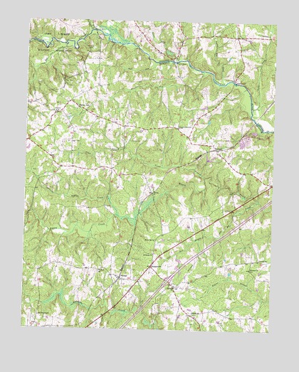
Warfield, VA USGS Topographic Map
Click on map above to begin viewing in our Map Viewer.

This topographic map contains these locations and features:
Feature Name Type Latitude Longitude GNIS ID View Map
Antioch ChurchChurchN36.8924°W77.7983°1462497View Map
Baskerville Airport (historical)AirportN36.9876°W77.7717°1498742View Map
Baskerville MillPopulated PlaceN36.9757°W77.7694°1499095View Map
Beaver Pond CreekStreamN36.9840°W77.7983°1462944View Map
Big BranchStreamN36.9271°W77.7569°1463311View Map
Central School (historical)SchoolN36.8829°W77.7783°1493967View Map
ChampPopulated PlaceN36.9765°W77.7706°1690726View Map
Clifton High School (historical)SchoolN36.9671°W77.8536°1493969View Map
ConcordPopulated PlaceN36.9571°W77.7986°1493970View Map
Concord-Brunswick ChurchChurchN36.9571°W77.7978°1465165View Map
Ebenezer ChurchChurchN36.8996°W77.7605°1466139View Map
Gilliam SchoolSchoolN36.8815°W77.7892°1467092View Map
Gills BridgeBridgeN36.9960°W77.8406°1467095View Map
Graves SchoolSchoolN36.9038°W77.7558°1467403View Map
Great BranchStreamN36.9368°W77.7842°1467421View Map
HarpersPopulated PlaceN36.9935°W77.7894°1690759View Map
Harpers BridgeBridgeN36.9835°W77.8000°1690760View Map
Harpers Mill (historical)LocaleN36.9838°W77.7997°1690761View Map
Hickory RunPopulated PlaceN36.9651°W77.8489°1499551View Map
Hickory RunStreamN36.9801°W77.7861°1467990View Map
Hickory Run School (historical)SchoolN36.9640°W77.8494°1493985View Map
Interchange 34CrossingN36.8949°W77.8019°1493990View Map
Jack Rock BranchStreamN36.9126°W77.7780°1468574View Map
Jones BridgeBridgeN36.9757°W77.7706°1493994View Map
KressPopulated PlaceN36.9304°W77.8103°1477468View Map
Lebanon ChurchChurchN36.9629°W77.8600°1469241View Map
Mercy See ChurchChurchN36.9110°W77.8086°1470365View Map
Miry RunStreamN36.9835°W77.8092°1470627View Map
Mount Zion ChurchChurchN36.8801°W77.8669°1471121View Map
Opossum Quarter CreekStreamN36.9213°W77.8278°1471935View Map
RawlingsPopulated PlaceN36.9485°W77.7789°1477662View Map
Rawlings Post OfficePost OfficeN36.9454°W77.7756°2767247View Map
Red Oak CreekStreamN36.9893°W77.8519°1473059View Map
Reedy CreekStreamN36.9646°W77.7611°1473117View Map
Saint James ChurchChurchN36.9054°W77.8094°1473730View Map
Saint James School (historical)SchoolN36.9051°W77.8097°1494027View Map
SturgeonvillePopulated PlaceN36.9007°W77.8103°1477788View Map
Sunnyside High School (historical)SchoolN36.9979°W77.7706°1690823View Map
Tommeheton CreekStreamN36.9963°W77.8422°1475771View Map
Turkey Egg CreekStreamN36.9749°W77.7750°1475945View Map
WarfieldPopulated PlaceN36.8957°W77.8258°1477858View Map
Warfield Baptist ChurchChurchN36.8965°W77.8269°1738273View Map
Warfield Census Designated PlaceCensusN36.8975°W77.8193°2584934View Map
Warfield Post OfficePost OfficeN36.9008°W77.8107°2767264View Map
Warfield SchoolSchoolN36.8985°W77.8369°1476338View Map

Note: Coordinates in the location and feature list above are referenced to NAD83 datum.


Copyright (C) 2008-2024 Ryan Niemi / Sunset Dynamics ... All Rights Reserved