TopoQuest Logo
Do you find TopoQuest useful?
Help keep TopoQuest running and adding new maps/features by donating!
Bitcoin:  19c7KJd3qBynnjoSw5npx9KScwjBe4ifkT
Litecoin:  LXs6TkuXGGXo1vDsWCkWVdjQX94eUKd6ui
Home View Maps Find Maps Find Places Resources & Links


Danieltown, Virginia Topographic Map

USGS Map Title: Danieltown, VA
USGS Map MRC: 36077H8
DRG (GeoTIFF) Download: o36077h8.tif


Neighboring USGS Topographic Map Quads:


  Blackstone West, VA  
37078A1
 

  Blackstone East, VA  
37077A8
 

  Darvills, VA  
37077A7
 

  Kenbridge East, VA  
36078H1
 

  Danieltown, VA  
36077H8
 

  Warfield, VA  
36077H7
 

  Forksville, VA  
36078G1
 

  Alberta, VA  
36077G8
 

  Lawrenceville, VA  
36077G7


Map MRC Location:

N37°
W78°
N37°
W77°
H8 H7 H6 H5 H4 H3 H2 H1
G8 G7 G6 G5 G4 G3 G2 G1
F8 F7 F6 F5 F4 F3 F2 F1
E8 E7 E6 E5 E4 E3 E2 E1
D8 D7 D6 D5 D4 D3 D2 D1
C8 C7 C6 C5 C4 C3 C2 C1
B8 B7 B6 B5 B4 B3 B2 B1
A8 A7 A6 A5 A4 A3 A2 A1
N36°
W78°
N36°
W77°

Danieltown, VA USGS 1:24K Topographic Map Preview:
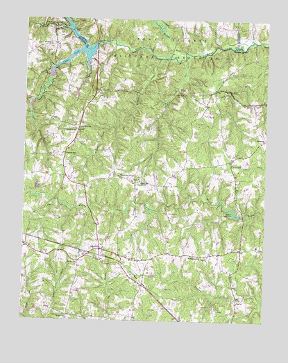
Danieltown, VA USGS Topographic Map
Click on map above to begin viewing in our Map Viewer.

This topographic map contains these locations and features:
Feature Name Type Latitude Longitude GNIS ID View Map
Barrows StorePopulated PlaceN36.9349°W77.9789°1493953View Map
Bennets CrossroadsPopulated PlaceN36.9046°W77.8872°1493954View Map
Bragg CemeteryCemeteryN36.8832°W77.8886°1463747View Map
Camp Pickett Lake 3500ReservoirN36.9815°W77.9815°1490489View Map
Cedar CreekStreamN36.9871°W77.9700°1464599View Map
Crooked CreekStreamN36.9963°W77.9775°1465462View Map
Daniels CemeteryCemeteryN36.9332°W77.9400°1465593View Map
DanieltownPopulated PlaceN36.9046°W77.9597°1492836View Map
Edmunds StorePopulated PlaceN36.8765°W77.9419°1493975View Map
Elmore CemeteryCemeteryN36.8818°W77.9064°1466263View Map
Flinn CemeteryCemeteryN36.8799°W77.8992°1466712View Map
Forest Hill SchoolSchoolN36.9063°W77.9983°1493978View Map
Hurricane BranchStreamN36.9865°W77.9169°1468418View Map
Jones CemeteryCemeteryN36.8882°W77.9511°1468825View Map
Jonesboro (historical)Populated PlaceN36.9799°W77.9603°1493996View Map
Jonesboro BridgeBridgeN36.9954°W77.9756°1468866View Map
Jonesboro ChurchChurchN36.9893°W77.9869°1468867View Map
Jonesboro SchoolSchoolN36.9543°W77.9731°1468868View Map
Kennedy BridgeBridgeN36.9896°W77.9628°1468951View Map
Little Mount ChurchChurchN36.9546°W77.9711°1469600View Map
Masons MillLocaleN36.9196°W77.8875°1494005View Map
Masons Mill DamDamN36.9192°W77.8876°1489257View Map
Masons Mill PondReservoirN36.9192°W77.8900°1502066View Map
Masons Mill School (historical)SchoolN36.9365°W77.8908°1494006View Map
Mount Pleasant Church (historical)ChurchN36.9010°W77.9067°1494010View Map
Mount Pleasant SchoolSchoolN36.9015°W77.9069°1471051View Map
Mount Zion Chuch (historical)ChurchN36.8996°W77.9714°1690072View Map
Mount Zion ChurchChurchN36.8771°W77.9772°1471120View Map
Mount Zion SchoolSchoolN36.8988°W77.9717°1471159View Map
New Horizon Baptist SchoolSchoolN36.9374°W77.9962°2465391View Map
Nottoway ReservoirReservoirN36.9866°W77.9724°1471680View Map
Nottoway River DamDamN36.9885°W77.9647°1490488View Map
OctagonPopulated PlaceN36.9029°W77.8986°1494015View Map
OrdsburgPopulated PlaceN36.9504°W77.8753°1477595View Map
Red Oak - Sturgeon Elementary SchoolSchoolN36.9065°W77.8786°2465122View Map
Red Oak DistrictCivilN36.8894°W77.9270°1927457View Map
Redoak School (historical)SchoolN36.9393°W77.9119°1494022View Map
Rocky RunStreamN36.9857°W77.9142°1473482View Map
Rocky Run ChurchChurchN36.9318°W77.9386°1473493View Map
South Branch Cedar CreekStreamN36.9663°W77.9950°1474835View Map
Stainback CemeteryCemeteryN36.9201°W77.9242°1475056View Map
Stewart CemeteryCemeteryN36.8888°W77.9258°1475130View Map
TobaccoPopulated PlaceN36.8899°W77.9375°1494035View Map
Trinity CemeteryCemeteryN36.9435°W77.8906°1475856View Map
Trinity Church (historical)ChurchN36.9438°W77.8900°1494036View Map
VotePopulated PlaceN36.9329°W77.9400°1494041View Map
Warrens StoreLocaleN36.9438°W77.9789°1476347View Map
WGNJ-FM (Alberta)TowerN36.8943°W77.8931°1502598View Map
Wheeler Mill (historical)LocaleN36.9224°W77.9608°1494044View Map
White Rock ChurchChurchN36.9354°W77.9494°1476635View Map
Wildcat CreekStreamN36.9840°W77.9289°1476714View Map
Winn CemeteryCemeteryN36.8799°W77.9300°1476864View Map

Note: Coordinates in the location and feature list above are referenced to NAD83 datum.


Copyright (C) 2008-2024 Ryan Niemi / Sunset Dynamics ... All Rights Reserved